- Доступность набора данных
- 2006-01-24T00:00:00Z–2011-05-13T00:00:00Z
- Производитель наборов данных
- Партнеры по науке о сохранении природы
- Теги
Описание
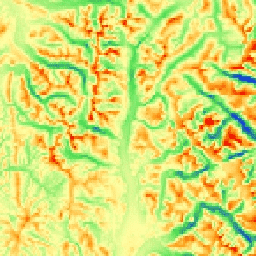
Индекс mTPI различает хребты и долины. Он рассчитывается с использованием данных о высоте для каждого местоположения, из которых вычитается средняя высота в пределах района. В индексе mTPI используются скользящие окна радиусом (км): 115,8, 89,9, 35,5, 13,1, 5,6, 2,8 и 1,2. Он основан на 30-метровой цифровой модели рельефа SRTM (доступна в Европе как USGS/SRTMGL1_003).
Наборы данных по экологически значимой геоморфологии (ERGo) организации Conservation Science Partners (CSP), содержащие подробные многомасштабные данные о формах рельефа и физиографических (или ландшафтных) особенностях ландшафта, содержат подробную информацию о формах рельефа и физиографических (или поверхностных) структурах. Хотя существует множество потенциальных применений этих данных, их первоначальная цель заключалась в разработке экологически значимой классификации и карты форм рельефа и физиографических классов, подходящих для планирования адаптации к изменению климата. Поскольку существует большая неопределенность, связанная с будущими климатическими условиями, и еще большая неопределенность в отношении экологических реакций, предоставление информации о том, что вряд ли изменится, обеспечивает прочную основу для разработки надежных планов адаптации к изменению климата. Количественная оценка этих характеристик ландшафта зависит от разрешения, поэтому мы предоставляем максимально возможное разрешение, учитывая масштабы и характеристики данного индекса.
Группы
Группы
Размер пикселя: 270 метров (все диапазоны)
| Имя | Единицы | Мин | Макс | Размер пикселя | Описание |
|---|---|---|---|---|---|
elevation | м | -8129* | 7905* | 270 метров | Значения mTPI, полученные с помощью SRTM, варьируются от отрицательных (впадины) до положительных (гребни). |
Условия эксплуатации
Условия эксплуатации
Цитаты
Теобальд, Д.М., Харрисон-Атлас, Д., Монахан, В.Б., и Альбано, К.М. (2015). Экологически значимые карты рельефа и физиографического разнообразия для планирования адаптации к изменению климата. PloS one, 10(12), e0143619
Исследуйте мир с помощью Earth Engine.
Редактор кода (JavaScript)
var dataset = ee.Image('CSP/ERGo/1_0/Global/SRTM_mTPI');
var srtmMtpi = dataset.select('elevation');
var srtmMtpiVis = {
  min: -200.0,
  max: 200.0,
  palette: ['0b1eff', '4be450', 'fffca4', 'ffa011', 'ff0000'],
};
Map.setCenter(-105.8636, 40.3439, 11);
Map.addLayer(srtmMtpi, srtmMtpiVis, 'SRTM mTPI');