- ডেটাসেটের উপলভ্যতা
- 2006-01-24T00:00:00Z–2011-05-13T00:00:00Z
- ডেটাসেট প্রযোজক
- সংরক্ষণ বিজ্ঞান অংশীদার
- ট্যাগ
বর্ণনা
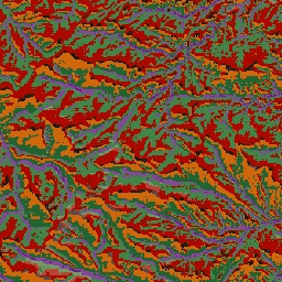
ALOS ল্যান্ডফর্ম ডেটাসেটটি কন্টিনিউয়াস হিট-ইনসোলেশন লোড ইনডেক্স (CHILI) এবং মাল্টি-স্কেল টপোগ্রাফিক পজিশন ইনডেক্স (mTPI) ডেটাসেট দুটিকে একত্রিত করে তৈরি করা ভূমিরূপ শ্রেণি প্রদান করে। এটি USGS-এর 10m NED DEM-এর উপর ভিত্তি করে তৈরি (যা EE-তে USGS/NED হিসেবে উপলব্ধ)।
কনজারভেশন সায়েন্স পার্টনার্স (সিএসপি)-এর ইকোলজিক্যালি রিলেভেন্ট জিওমরফোলজি (ইআরগো) ডেটাসেট, ল্যান্ডফর্মস অ্যান্ড ফিজিওগ্রাফি-তে ভূমিরূপ এবং ভূপ্রাকৃতিক (ভূমির বিভিন্ন দিক বা ফ্যাসেট নামেও পরিচিত) বিন্যাসের উপর বিস্তারিত, বহু-মাত্রিক উপাত্ত রয়েছে। যদিও এই উপাত্তের অনেক সম্ভাব্য ব্যবহার রয়েছে, তবে এর মূল উদ্দেশ্য ছিল জলবায়ু অভিযোজন পরিকল্পনার জন্য উপযুক্ত ভূমিরূপ এবং ভূপ্রাকৃতিক শ্রেণিগুলোর একটি পরিবেশগতভাবে প্রাসঙ্গিক শ্রেণিবিন্যাস ও মানচিত্র তৈরি করা। যেহেতু ভবিষ্যতের জলবায়ু পরিস্থিতি নিয়ে ব্যাপক অনিশ্চয়তা রয়েছে এবং পরিবেশগত প্রতিক্রিয়া নিয়ে আরও বেশি অনিশ্চয়তা বিদ্যমান, তাই কোনটির পরিবর্তন হওয়ার সম্ভাবনা কম সে সম্পর্কে তথ্য প্রদান করা ব্যবস্থাপকদের জন্য একটি শক্তিশালী জলবায়ু অভিযোজন পরিকল্পনা তৈরির মজবুত ভিত্তি প্রদান করে। ভূ-প্রকৃতির এই বৈশিষ্ট্যগুলোর পরিমাণগত পরিমাপ রেজোলিউশনের উপর সংবেদনশীল, তাই আমরা একটি নির্দিষ্ট সূচকের পরিধি এবং বৈশিষ্ট্য বিবেচনা করে সর্বোচ্চ সম্ভাব্য রেজোলিউশন প্রদান করি।
ব্যান্ড
ব্যান্ড
পিক্সেল সাইজ: ১০ মিটার (সকল ব্যান্ড)
| নাম | পিক্সেল আকার | বর্ণনা |
|---|---|---|
constant | ১০ মিটার | NED-উদ্ভূত ভূমিরূপ শ্রেণী |
ধ্রুবক শ্রেণী সারণী
| মূল্য | রঙ | বর্ণনা |
|---|---|---|
| ১১ | #১৪১৪১৪ | চূড়া/শৈলশিরা (উষ্ণ) |
| ১২ | #৩৮৩৮৩৮ | চূড়া/শৈলশিরা |
| ১৩ | #৮০৮০৮০ | চূড়া/শৈলশিরা (শীতল) |
| ১৪ | #ebeb8f | পর্বত/বিভাজন |
| ১৫ | #f7d311 | ক্লিফ |
| ২১ | #aa0000 | উপরের ঢাল (উষ্ণ) |
| ২২ | #d89382 | উপরের ঢাল |
| ২৩ | #ddc9c9 | উপরের ঢাল (ঠান্ডা) |
| ২৪ | #dccdce | উপরের ঢাল (সমতল) |
| ৩১ | #1c6330 | নিম্ন ঢাল (উষ্ণ) |
| ৩২ | #68aa63 | নিম্ন ঢাল |
| ৩৩ | #b5c98e | নিম্ন ঢাল (ঠান্ডা) |
| ৩৪ | #e1f0e5 | নিম্ন ঢাল (সমতল) |
| ৪১ | #a975ba | উপত্যকা |
| ৪২ | #6f198c | উপত্যকা (সংকীর্ণ) |
ব্যবহারের শর্তাবলী
ব্যবহারের শর্তাবলী
উদ্ধৃতি
থিওবল্ড, ডিএম, হ্যারিসন-অ্যাটলাস, ডি., মোনাহান, ডব্লিউবি, এবং আলবানো, সিএম (2015)। জলবায়ু অভিযোজন পরিকল্পনার জন্য ভূমিরূপ এবং ভূ-প্রাকৃতিক বৈচিত্র্যের পরিবেশগতভাবে প্রাসঙ্গিক মানচিত্র। প্লস ওয়ান, 10(12), e0143619
আর্থ ইঞ্জিনের সাহায্যে ঘুরে দেখুন
কোড এডিটর (জাভাস্ক্রিপ্ট)
var dataset = ee.Image('CSP/ERGo/1_0/US/landforms');
var landforms = dataset.select('constant');
var landformsVis = {
  min: 11.0,
  max: 42.0,
  palette: [
    '141414', '383838', '808080', 'ebeb8f', 'f7d311', 'aa0000', 'd89382',
    'ddc9c9', 'dccdce', '1c6330', '68aa63', 'b5c98e', 'e1f0e5', 'a975ba',
    '6f198c'
  ],
};
Map.setCenter(-105.58, 40.5498, 11);
Map.addLayer(landforms, landformsVis, 'Landforms');