- Доступность набора данных
- 2006-01-24T00:00:00Z–2011-05-13T00:00:00Z
- Производитель наборов данных
- Партнеры по науке о сохранении природы
- Теги
Описание
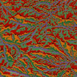
Набор данных ALOS Landform содержит классы форм рельефа, созданные путем объединения данных Continuous Heat-Insolation Load Index (CHILI) и multiscale Topographic Position Index (mTPI). Он основан на цифровой модели рельефа США с разрешением 10 м (доступна в Европе как USGS/NED).
Наборы данных по экологически значимой геоморфологии (ERGo) организации Conservation Science Partners (CSP), содержащие подробные многомасштабные данные о формах рельефа и физиографических (или ландшафтных) особенностях ландшафта, содержат подробную информацию о формах рельефа и физиографических (или поверхностных) структурах. Хотя существует множество потенциальных применений этих данных, их первоначальная цель заключалась в разработке экологически значимой классификации и карты форм рельефа и физиографических классов, подходящих для планирования адаптации к изменению климата. Поскольку существует большая неопределенность, связанная с будущими климатическими условиями, и еще большая неопределенность в отношении экологических реакций, предоставление информации о том, что вряд ли изменится, обеспечивает прочную основу для разработки надежных планов адаптации к изменению климата. Количественная оценка этих характеристик ландшафта зависит от разрешения, поэтому мы предоставляем максимально возможное разрешение, учитывая масштабы и характеристики данного индекса.
Группы
Группы
Размер пикселя: 10 метров (все диапазоны)
| Имя | Размер пикселя | Описание |
|---|---|---|
constant | 10 метров | Классы форм рельефа, полученные с помощью NED |
таблица постоянных классов
| Ценить | Цвет | Описание |
|---|---|---|
| 11 | #141414 | Пик/гребень (теплый) |
| 12 | #383838 | Пик/гребень |
| 13 | #808080 | Пик/гребень (холодный) |
| 14 | #ebeb8f | Гора/водораздел |
| 15 | #f7d311 | Утес |
| 21 | #aa0000 | Верхний склон (теплый) |
| 22 | #d89382 | Верхний склон |
| 23 | #ddc9c9 | Верхний склон (прохладный) |
| 24 | #dccdce | Верхний склон (плоский) |
| 31 | #1c6330 | Нижний склон (теплый) |
| 32 | #68aa63 | Нижний склон |
| 33 | #b5c98e | Нижний склон (прохладный) |
| 34 | #e1f0e5 | Нижний склон (плоский) |
| 41 | #a975ba | Долина |
| 42 | #6f198c | Долина (узкая) |
Условия эксплуатации
Условия эксплуатации
Цитаты
Теобальд, Д.М., Харрисон-Атлас, Д., Монахан, В.Б., и Альбано, К.М. (2015). Экологически значимые карты рельефа и физиографического разнообразия для планирования адаптации к изменению климата. PloS one, 10(12), e0143619
Исследуйте мир с помощью Earth Engine.
Редактор кода (JavaScript)
var dataset = ee.Image('CSP/ERGo/1_0/US/landforms');
var landforms = dataset.select('constant');
var landformsVis = {
  min: 11.0,
  max: 42.0,
  palette: [
    '141414', '383838', '808080', 'ebeb8f', 'f7d311', 'aa0000', 'd89382',
    'ddc9c9', 'dccdce', '1c6330', '68aa63', 'b5c98e', 'e1f0e5', 'a975ba',
    '6f198c'
  ],
};
Map.setCenter(-105.58, 40.5498, 11);
Map.addLayer(landforms, landformsVis, 'Landforms');