Набор данных Physiographic Diversity представляет собой индекс разнообразия физиографических типов. Он был рассчитан с использованием индекса разнообразия Шеннона в различных масштабах (км): 115,8, 89,9, 35,5, 13,1, 5,6, 2,8 и 1,2. Он основан на 10-метровой цифровой модели рельефа (NED) Геологической службы США (USGS) (доступной в Восточной Европе как USGS/NED).
Наборы данных по экологически релевантной геоморфологии (ERGo), формам рельефа и физиографии, разработанные Conservation Science Partners (CSP), содержат подробные многомасштабные данные о формах рельефа и физиографических (т.н. «фасетных» структурах). Несмотря на множество потенциальных применений этих данных, изначальной целью их создания была разработка экологически релевантной классификации и карты форм рельефа и физиографических классов, подходящих для планирования адаптации к изменению климата. В связи с высокой неопределенностью, связанной с будущими климатическими условиями, и еще большей неопределенностью, связанной с экологическими реакциями, предоставление информации о том, что вряд ли изменится, дает руководителям надежную основу для разработки надежных планов адаптации к изменению климата. Количественная оценка этих характеристик ландшафта чувствительна к разрешению, поэтому мы предоставляем максимально возможное разрешение с учетом масштаба и характеристик данного индекса.
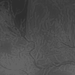
Набор данных «Физиографическое разнообразие» содержит индекс разнообразия физиографических типов. Он был рассчитан с использованием индекса разнообразия Шеннона в различных масштабах (км): 115,8, 89,9, 35,5, 13,1, 5,6, 2,8 и 1,2. Он основан на 10-метровой цифровой модели рельефа (NED) Геологической службы США (USGS) (доступной в Восточной Европе как USGS/NED). Наука о сохранении…
[null,null,[],[[["\u003cp\u003eThe Physiographic Diversity dataset offers an index of landform diversity across the US, calculated using the Shannon diversity index at multiple scales.\u003c/p\u003e\n"],["\u003cp\u003eIt's based on the USGS's 10m NED DEM and is available at a 270-meter resolution.\u003c/p\u003e\n"],["\u003cp\u003eDeveloped by Conservation Science Partners, this dataset is intended for climate adaptation planning and ecological research.\u003c/p\u003e\n"],["\u003cp\u003eThe data is provided under a CC-BY-NC-SA-4.0 license, encouraging non-commercial use with attribution.\u003c/p\u003e\n"],["\u003cp\u003eThe dataset is freely accessible for research, education, and nonprofit purposes through Google Earth Engine.\u003c/p\u003e\n"]]],[],null,["# US NED Physiographic Diversity\n\nDataset Availability\n: 2006-01-24T00:00:00Z--2011-05-13T00:00:00Z\n\nDataset Provider\n:\n\n\n [Conservation Science Partners](https://www.csp-inc.org/)\n\nTags\n:\n[aspect](/earth-engine/datasets/tags/aspect) [csp](/earth-engine/datasets/tags/csp) [elevation](/earth-engine/datasets/tags/elevation) [elevation-topography](/earth-engine/datasets/tags/elevation-topography) [ergo](/earth-engine/datasets/tags/ergo) [geophysical](/earth-engine/datasets/tags/geophysical) [landforms](/earth-engine/datasets/tags/landforms) [slope](/earth-engine/datasets/tags/slope) [topography](/earth-engine/datasets/tags/topography) [us](/earth-engine/datasets/tags/us) \n\n#### Description\n\nThe Physiographic Diversity dataset provides an index of the diversity of\nphysiographic types. It was calculated using the Shannon diversity index at\nmultiple scales (km): 115.8, 89.9, 35.5, 13.1, 5.6, 2.8, and 1.2. It is\nbased on the USGS's 10m NED DEM (available in EE as USGS/NED).\n\nThe Conservation Science Partners (CSP) Ecologically Relevant Geomorphology\n(ERGo) Datasets, Landforms and Physiography contain detailed, multi-scale\ndata on landforms and physiographic (aka land facet) patterns. Although\nthere are many potential uses of these data, the original purpose for these\ndata was to develop an ecologically relevant classification and map of\nlandforms and physiographic classes that are suitable for climate adaptation\nplanning. Because there is large uncertainty associated with future climate\nconditions and even more uncertainty around ecological responses, providing\ninformation about what is unlikely to change offers a strong foundation for\nmanagers to build robust climate adaptation plans. The quantification of\nthese features of the landscape is sensitive to the resolution, so we\nprovide the highest resolution possible given the extent and characteristics\nof a given index.\n\n### Bands\n\n\n**Pixel Size**\n\n270 meters\n\n**Bands**\n\n| Name | Min | Max | Pixel Size | Description |\n|------|-----|-----|------------|-------------------------|\n| `b1` | 0 | 1 | meters | Physiographic diversity |\n\n### Terms of Use\n\n**Terms of Use**\n\n[CC-BY-NC-SA-4.0](https://spdx.org/licenses/CC-BY-NC-SA-4.0.html)\n\n### Citations\n\nCitations:\n\n- Theobald, D. M., Harrison-Atlas, D., Monahan, W. B., \\& Albano, C. M.\n (2015). Ecologically-relevant maps of landforms and physiographic diversity\n for climate adaptation planning. PloS one, 10(12),\n [e0143619](https://journals.plos.org/plosone/article?id=10.1371/journal.pone.0143619)\n\n### Explore with Earth Engine\n\n| **Important:** Earth Engine is a platform for petabyte-scale scientific analysis and visualization of geospatial datasets, both for public benefit and for business and government users. Earth Engine is free to use for research, education, and nonprofit use. To get started, please [register for Earth Engine access.](https://console.cloud.google.com/earth-engine)\n\n### Code Editor (JavaScript)\n\n```javascript\nvar dataset = ee.Image('CSP/ERGo/1_0/US/physioDiversity');\nvar physiographicDiversity = dataset.select('b1');\nvar physiographicDiversityVis = {\n min: 0.0,\n max: 1.0,\n};\nMap.setCenter(-94.625, 39.825, 7);\nMap.addLayer(\n physiographicDiversity, physiographicDiversityVis,\n 'Physiographic Diversity');\n```\n[Open in Code Editor](https://code.earthengine.google.com/?scriptPath=Examples:Datasets/CSP/CSP_ERGo_1_0_US_physioDiversity) \n[US NED Physiographic Diversity](/earth-engine/datasets/catalog/CSP_ERGo_1_0_US_physioDiversity) \nThe Physiographic Diversity dataset provides an index of the diversity of physiographic types. It was calculated using the Shannon diversity index at multiple scales (km): 115.8, 89.9, 35.5, 13.1, 5.6, 2.8, and 1.2. It is based on the USGS's 10m NED DEM (available in EE as USGS/NED). The Conservation Science ... \nCSP/ERGo/1_0/US/physioDiversity, aspect,csp,elevation,elevation-topography,ergo,geophysical,landforms,slope,topography,us \n2006-01-24T00:00:00Z/2011-05-13T00:00:00Z \n12.54 -132.09 56.21 -60.35 \nGoogle Earth Engine \nhttps://developers.google.com/earth-engine/datasets\n\n- [](https://doi.org/https://www.csp-inc.org/)\n- [](https://doi.org/https://developers.google.com/earth-engine/datasets/catalog/CSP_ERGo_1_0_US_physioDiversity)"]]