- Доступность набора данных
- 2016-01-01T00:00:00Z–2016-12-31T00:00:00Z
- Производитель наборов данных
- Партнеры по науке о сохранении природы
- Каденция
- 1 год
- Теги
- tnc
Описание
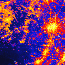
Глобальный набор данных об изменении человеком (gHM) предоставляет кумулятивную оценку антропогенного воздействия на наземные территории по всему миру с разрешением в 1 квадратный километр. Значения gHM варьируются от 0,0 до 1,0 и рассчитываются путем оценки доли данной местности (пикселя), подвергшейся изменению, а также предполагаемой интенсивности изменений, связанных с определенным типом антропогенного воздействия или «стрессовым фактором». Пять основных антропогенных стрессовых факторов примерно 2016 года были нанесены на карту с использованием 13 отдельных наборов данных:
- населенные пункты (плотность населения, застроенные территории)
- сельское хозяйство (пахотные земли, животноводство)
- Транспорт (крупные, второстепенные и двухпутные дороги; железные дороги)
- добыча полезных ископаемых и производство энергии
- электротехническая инфраструктура (линии электропередачи, ночное освещение)
Дополнительные методологические сведения см. в статье. Данный объект был перепроецирован в систему координат WGS84 для использования в Earth Engine.
Группы
Группы
Размер пикселя: 1000 метров (все диапазоны)
| Имя | Единицы | Мин | Макс | Размер пикселя | Описание |
|---|---|---|---|---|---|
gHM | км^2 | 0 | 1 | 1000 метров | глобальная модификация человека |
Условия эксплуатации
Условия эксплуатации
Цитаты
Кеннеди, К.М., Дж.Р. Оуклиф, Д.М. Теобальд, С. Барух-Мурдо и Дж. Кисекер. 2019. Управление «серединой»: изменение приоритетов в области охраны природы на основе глобального градиента антропогенного воздействия. Global Change Biology 00:1-16. doi:10.1111/gcb.14549
Исследуйте мир с помощью Earth Engine.
Редактор кода (JavaScript)
var dataset = ee.ImageCollection('CSP/HM/GlobalHumanModification');

var visualization = {
  bands: ['gHM'],
  min: 0.0,
  max: 1.0,
  palette: ['0c0c0c', '071aff', 'ff0000', 'ffbd03', 'fbff05', 'fffdfd']
};

Map.centerObject(dataset);

Map.addLayer(dataset, visualization, 'Human modification');