- ডেটাসেটের প্রাপ্যতা
- 2022-01-01T00:00:00Z–2022-02-01T00:00:00Z
- ডেটাসেট প্রযোজক
- ওক রিজ জাতীয় পরীক্ষাগার
- ট্যাগ
- ইউক্রেনের
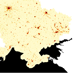
বর্ণনা
ল্যান্ডস্ক্যান হাই ডেফিনিশন (এইচডি) ৩ আর্ক-সেকেন্ড (~১০০ মিটার) রেজোলিউশনে গ্রিডভিত্তিক জনসংখ্যার আনুমানিক হিসাব প্রদান করে। প্রতিটি ল্যান্ডস্ক্যান এইচডি সেলের মান একটি পরিবেষ্টিত (অর্থাৎ ২৪ ঘণ্টার গড়) জনসংখ্যা গণনার আনুমানিক হিসাবকে প্রতিনিধিত্ব করে। এইভাবে, ডেটা শুধুমাত্র একটি আবাসিক এলাকার পরিবর্তে দিন ও রাত জুড়ে মানুষের সম্ভাব্য কার্যকলাপের সম্পূর্ণ পরিসরকে ধারণ করে। ল্যান্ডস্ক্যান এইচডি মডেলটি বিভিন্ন উৎস থেকে বর্তমান ভূমি ব্যবহার এবং অবকাঠামোগত ডেটা অন্তর্ভুক্ত করে, ওআরএনএল-এর পপুলেশন ডেনসিটি টেবিলস (পিডিটি) প্রকল্প থেকে প্রাপ্ত স্থাপনা দখলের আনুমানিক হিসাব প্রয়োগ করে এবং উচ্চ-ক্ষমতাসম্পন্ন কম্পিউটিং পরিবেশ ব্যবহার করে দ্রুত ভবন কাঠামো ও আশেপাশের এলাকাগুলোর মানচিত্র তৈরি করার জন্য ওআরএনএল-এ বিকশিত অভিনব ইমেজ প্রসেসিং অ্যালগরিদমকে কাজে লাগায়।
এই তথ্য প্রণয়নে ব্যবহৃত উপ-জাতীয় জনসংখ্যার গণনার উৎস হলো ইউক্রেনের রাষ্ট্রীয় পরিসংখ্যান পরিষেবা ।
এই উপ-জাতীয় অনুমানগুলি সিআইএ ওয়ার্ল্ড ফ্যাক্টবুক দ্বারা প্রদত্ত দেশের মোট জনসংখ্যার সাথে সামঞ্জস্য করা হয়েছিল।
ব্যান্ড
ব্যান্ড
পিক্সেল সাইজ: ১০০ মিটার (সকল ব্যান্ড)
| নাম | মিনিট | ম্যাক্স | পিক্সেল আকার | বর্ণনা |
|---|---|---|---|---|
population | ০* | ১০২০* | ১০০ মিটার | ২৪ ঘণ্টার গড় জনসংখ্যা গণনার অনুমান |
ব্যবহারের শর্তাবলী
ব্যবহারের শর্তাবলী
এই ডেটাসেটটি CC-BY 4.0 লাইসেন্সের অধীনে রয়েছে।
আর্থ ইঞ্জিন দিয়ে অন্বেষণ করুন
কোড এডিটর (জাভাস্ক্রিপ্ট)
var dataset = ee.Image('DOE/ORNL/LandScan_HD/Ukraine_202201');
var vis = {
  min: 0.0,
  max: 10.0,
  palette: ['lemonchiffon', 'khaki', 'orange', 'orangered', 'red', 'maroon'],
};
Map.centerObject(dataset);
Map.addLayer(dataset, vis, 'Population Count');