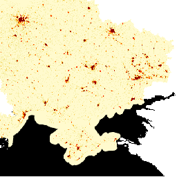
LandScan High Definition (HD)
zawiera oszacowania liczby ludności w siatce o rozdzielczości 3 sekund łuku (~100 m). Wartości w każdej komórce LandScan HD to szacunkowa liczba ludności w otoczeniu (czyli średnia z 24 godzin). W ten sposób dane obejmują pełny potencjalny obszar aktywności osób w ciągu dnia i nocy, a nie tylko miejsce zamieszkania. Model LandScan HD wykorzystuje aktualne dane o użytkowaniu gruntów i infrastrukturze z różnych źródeł, stosuje szacunki dotyczące zajętości obiektów z projektu ORNL Population Density Tables (PDT) i wykorzystuje opracowane w ORNL nowe algorytmy przetwarzania obrazów do szybkiego mapowania struktur budynków i obszarów sąsiedzkich przy użyciu środowisk obliczeniowych o wysokiej wydajności.
Źródłem danych o liczbie ludności na poziomie podkrajowym, które zostały wykorzystane do opracowania tych danych, jest Państwowa Służba Statystyczna Ukrainy.
Te szacunki na poziomie podkrajowym zostały dostosowane do łącznej populacji kraju podanej w CIA World Factbook.
LandScan High Definition (HD) to oszacowania liczby ludności w siatce o rozdzielczości 3 sekund łuku (~100 m). Wartości w każdej komórce LandScan HD reprezentują szacunkową liczbę ludności w otoczeniu (czyli średnią z 24 godzin). W ten sposób dane obejmują pełny potencjał aktywności ludzi w ciągu dnia i nocy…
[null,null,[],[[["\u003cp\u003eThis dataset provides gridded population estimates for Ukraine at ~100m resolution for January 2022.\u003c/p\u003e\n"],["\u003cp\u003ePopulation estimates represent a 24-hour average, reflecting potential activity space rather than just residential locations.\u003c/p\u003e\n"],["\u003cp\u003eLandScan HD utilizes land use, infrastructure data, and novel image processing algorithms to generate these estimates.\u003c/p\u003e\n"],["\u003cp\u003eThe dataset is licensed under CC-BY 4.0 and is available for exploration within Google Earth Engine.\u003c/p\u003e\n"],["\u003cp\u003ePopulation counts were derived from the State Statistics Service of Ukraine and the CIA World Factbook.\u003c/p\u003e\n"]]],["The LandScan High Definition (HD) dataset from Oak Ridge National Laboratory offers gridded population estimates for Ukraine, captured in January 2022. This data provides a 24-hour average population count at a 100-meter resolution. The dataset, available through Google Earth Engine, uses subnational population data from Ukraine's State Statistics Service, adjusted to match the CIA World Factbook's total population count. Users can access and visualize this dataset, which is licensed under CC-BY 4.0, using Earth Engine's code editor.\n"],null,["# LandScan High Definition Data for Ukraine, January 2022\n\nDataset Availability\n: 2022-01-01T00:00:00Z--2022-02-01T00:00:00Z\n\nDataset Provider\n:\n\n\n [Oak Ridge National Laboratory](https://landscan.ornl.gov/ukraine-landscan-hd-data)\n\nTags\n:\n [landscan](/earth-engine/datasets/tags/landscan) [population](/earth-engine/datasets/tags/population) \nukraine \n\n#### Description\n\n[LandScan High Definition (HD)](https://landscan.ornl.gov)\nprovides gridded population estimates at 3\narc-second (\\~100m) resolution. Values for each LandScan HD cell represent an\nambient (i.e. 24 hour average) population count estimate. In this way, the\ndata capture the full potential activity space of people throughout the\ncourse of the day and night rather than just a residential location. The\nLandScan HD model incorporates current land use and infrastructure data from\na variety of sources, applies facility occupancy estimates from ORNL's\nPopulation Density Tables (PDT) project, and leverages novel image\nprocessing algorithms developed at ORNL to rapidly map building\nstructures and neighborhood areas using high-performance computing\nenvironments.\n\nThe source for subnational population counts used in the development of this\ndata comes from\n[State Statistics Service of Ukraine](https://ukrstat.org/en/operativ/operativ2021/ds/kn/arh_kn2021_e.html).\n\nThese subnational estimates were adjusted to the country total population\nprovided by the\n[CIA World Factbook](https://www.cia.gov/the-world-factbook/countries/ukraine/#people-and-society).\n\n### Bands\n\n\n**Pixel Size**\n\n100 meters\n\n**Bands**\n\n| Name | Min | Max | Pixel Size | Description |\n|--------------|-----|--------|------------|-------------------------------------------|\n| `population` | 0\\* | 1020\\* | meters | 24 hour average population count estimate |\n\n\\* estimated min or max value\n\n### Terms of Use\n\n**Terms of Use**\n\nThis dataset is licensed under\n[CC-BY 4.0](https://creativecommons.org/licenses/by/4.0/).'\n\n### Explore with Earth Engine\n\n| **Important:** Earth Engine is a platform for petabyte-scale scientific analysis and visualization of geospatial datasets, both for public benefit and for business and government users. Earth Engine is free to use for research, education, and nonprofit use. To get started, please [register for Earth Engine access.](https://console.cloud.google.com/earth-engine)\n\n### Code Editor (JavaScript)\n\n```javascript\nvar dataset = ee.Image('DOE/ORNL/LandScan_HD/Ukraine_202201');\nvar vis = {\n min: 0.0,\n max: 10.0,\n palette: ['lemonchiffon', 'khaki', 'orange', 'orangered', 'red', 'maroon'],\n};\nMap.centerObject(dataset);\nMap.addLayer(dataset, vis, 'Population Count');\n```\n[Open in Code Editor](https://code.earthengine.google.com/?scriptPath=Examples:Datasets/DOE/DOE_ORNL_LandScan_HD_Ukraine_202201) \n[LandScan High Definition Data for Ukraine, January 2022](/earth-engine/datasets/catalog/DOE_ORNL_LandScan_HD_Ukraine_202201) \nLandScan High Definition (HD) provides gridded population estimates at 3 arc-second (\\~100m) resolution. Values for each LandScan HD cell represent an ambient (i.e. 24 hour average) population count estimate. In this way, the data capture the full potential activity space of people throughout the course of the day and night ... \nDOE/ORNL/LandScan_HD/Ukraine_202201, landscan,population \n2022-01-01T00:00:00Z/2022-02-01T00:00:00Z \n44.175 22.125 52.4 40.225 \nGoogle Earth Engine \nhttps://developers.google.com/earth-engine/datasets\n\n- [](https://doi.org/https://landscan.ornl.gov/ukraine-landscan-hd-data)\n- [](https://doi.org/https://developers.google.com/earth-engine/datasets/catalog/DOE_ORNL_LandScan_HD_Ukraine_202201)"]]