- Доступность набора данных
- 2022-01-01T00:00:00Z–2022-02-01T00:00:00Z
- Производитель наборов данных
- Национальная лаборатория Ок-Ридж
- Теги
- Украина
Описание
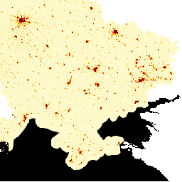
LandScan High Definition (HD) предоставляет оценки численности населения в виде сетки с разрешением 3 угловые секунды (~100 м). Значения для каждой ячейки LandScan HD представляют собой оценку численности населения в течение суток (т.е. среднесуточное значение). Таким образом, данные охватывают все потенциальное пространство активности людей в течение дня и ночи, а не только жилой район. Модель LandScan HD включает в себя текущие данные о землепользовании и инфраструктуре из различных источников, применяет оценки заполняемости объектов из проекта ORNL Population Density Tables (PDT) и использует новые алгоритмы обработки изображений, разработанные в ORNL, для быстрого картирования зданий и районов с использованием высокопроизводительных вычислительных сред.
Источником данных о численности населения на субнациональном уровне, использованных при составлении этих данных, является Государственная статистическая служба Украины .
Эти оценки на субнациональном уровне были скорректированы с учетом общей численности населения страны, предоставленной справочником CIA World Factbook .
Группы
Группы
Размер пикселя: 100 метров (все диапазоны)
| Имя | Мин | Макс | Размер пикселя | Описание |
|---|---|---|---|---|
population | 0* | 1020* | 100 метров | Оценка среднесуточной численности населения |
Условия эксплуатации
Условия эксплуатации
Данный набор данных распространяется под лицензией CC-BY 4.0 .
Исследуйте мир с помощью Earth Engine.
Редактор кода (JavaScript)
var dataset = ee.Image('DOE/ORNL/LandScan_HD/Ukraine_202201');
var vis = {
  min: 0.0,
  max: 10.0,
  palette: ['lemonchiffon', 'khaki', 'orange', 'orangered', 'red', 'maroon'],
};
Map.centerObject(dataset);
Map.addLayer(dataset, vis, 'Population Count');