Ten zbiór danych zawiera 6-dniowe prognozy pól modelu fal generowane przez system ECMWF Integrated Forecasting System (IFS) w rozdzielczości 0,25 stopnia.
Nazywamy je danymi w czasie zbliżonym do rzeczywistego (Near-Realtime, NRT), ponieważ nowe produkty są udostępniane 2 razy dziennie po udostępnieniu danych prognozy ECMWF w czasie rzeczywistym, których są podzbiorem. Jest to strumień „Short-Cutoff”, co oznacza, że prognozy
mają krótszy zakres niż standardowe prognozy IFS WAVE. Dane mogą być rozpowszechniane i wykorzystywane komercyjnie z odpowiednim podaniem źródła.
Produkty są dostępne w Earth Engine od wdrożenia cyklu 49r1 12 listopada 2024 r. Wcześniejsze produkty nie są uwzględnione. Ogólne informacje o korzystaniu ze zbiorów danych ECMWF NRT znajdziesz w dokumentacji dla użytkowników.
Pliki źródłowe są dostępne w Google Cloud Marketplace.
Pasma
Rozmiar piksela 28000 metrów
Pasma
Nazwa
Jednostki
Min.
Maks.
Rozmiar piksela
Opis
mean_zero_crossing_wave_period_sfc
s
0,889602*
17,573*
metry
Średnia długość czasu między momentami, w których powierzchnia morza lub oceanu przekracza średni poziom morza.
Średnia wysokość najwyższej trzeciej części fal na powierzchni oceanu lub morza
generowanych przez wiatr i falowanie. Jest to odległość pionowa między grzbietem a doliną fali.
mean_wave_direction_sfc
deg
0
360
metry
Średni kierunek fal na powierzchni oceanu lub morza względem położenia geograficznego bieguna północnego (np. 0 oznacza „z północy”, a 90 – „ze wschodu”).
peak_wave_period_sfc
s
1,03074*
23,7889*
metry
Okres najbardziej energetycznych fal oceanicznych generowanych przez lokalne wiatry i związanych z falą przyboju. Okres fali to średni czas, jaki upływa między przejściem przez stały punkt dwóch kolejnych grzbietów fal na powierzchni oceanu lub morza.
mean_wave_period_sfc
s
1,04148*
18,3643*
metry
Średni czas, jaki upływa między przejściem przez stały punkt dwóch kolejnych grzbietów fal na powierzchni oceanu lub morza.
* szacunkowa wartość minimalna lub maksymalna
Właściwości obrazu
Właściwości obrazu
Nazwa
Typ
Opis
creation_day
PRZ
Dzień miesiąca, w którym utworzono prognozę.
creation_doy
PRZ
Dzień roku, w którym utworzono prognozę.
creation_hour
PRZ
Godzina, o której utworzono prognozę.
creation_month
PRZ
Miesiąc roku, w którym utworzono prognozę.
creation_time
PRZ
Czas utworzenia prognozy w milisekundach od początku epoki systemu Unix.
creation_year
PRZ
Rok utworzenia prognozy.
forecast_hours
PRZ
Liczba godzin w przyszłości w stosunku do creation_time, na które jest tworzona prognoza.
forecast_time
PRZ
Czas prognozy w milisekundach od początku epoki uniksowej.
model
CIĄG ZNAKÓW
Model prognozowania ECMWF:
ifs: Integrated Forecasting System
aifs: Artificial Intelligence/Integrated Forecasting System
strumień
CIĄG ZNAKÓW
Strumień, z którego pobrano zmienne. Pełną listę znajdziesz tutaj.
Ten zbiór danych zawiera 6-dniowe prognozy pól modelu fal generowane przez system ECMWF Integrated Forecasting System (IFS) w rozdzielczości 0,25 stopnia. Określamy je jako dane w czasie zbliżonym do rzeczywistego (NRT), ponieważ nowe produkty są udostępniane 2 razy dziennie po udostępnieniu danych prognozy w czasie rzeczywistym ECMWF, z których pochodzą te dane.
[null,null,[],[],[],null,["Dataset Availability\n: 2024-11-12T18:00:00Z--2025-09-01T06:00:00Z\n\nDataset Provider\n:\n\n\n [ECMWF](https://www.ecmwf.int/en/forecasts/datasets/open-data)\n\nCadence\n: 12 Hours\n\nTags\n:\n[climate](/earth-engine/datasets/tags/climate) [ecmwf](/earth-engine/datasets/tags/ecmwf) [forecast](/earth-engine/datasets/tags/forecast) [global](/earth-engine/datasets/tags/global) [ocean](/earth-engine/datasets/tags/ocean) \n\nDescription \nThis dataset contains 6-day forecasts of the wave model fields generated by\nthe ECMWF Integrated Forecasting System (IFS) at 0.25 degree resolution.\nWe refer to these as Near-Realtime (NRT) because new products are released\ntwice a day after the release of the ECMWF realtime forecast data, of which\nthis is a subset. This is a \"Short-Cutoff\" stream, meaning the forecasts\nhave a shorter range than the standard IFS WAVE forecasts. Data may be\ndistributed and used commercially with\n[proper attribution](https://apps.ecmwf.int/datasets/licences/general/).\n\nProducts are available in Earth Engine starting with the implementation of\n[Cycle 49r1](https://confluence.ecmwf.int/display/FCST/Implementation+of+IFS+Cycle+49r1)\non 2024-11-12; earlier products are not included. For general information\nabout how to use ECMWF NRT datasets, see their\n[user documentation](https://confluence.ecmwf.int/display/DAC/ECMWF+open+data%3A+real-time+forecasts+from+IFS+and+AIFS).\nSources files are available in the\n[Google Cloud marketplace](https://console.cloud.google.com/marketplace/product/bigquery-public-data/open-data-ecmwf).\n\nBands\n\n\n**Pixel Size**\n\n28000 meters\n\n**Bands**\n\n| Name | Units | Min | Max | Pixel Size | Description |\n|-----------------------------------------------------------|---------|-------------|-----------|------------|------------------------------------------------------------------------------------------------------------------------------------------------------------------------------------------------------------------------------------------------|\n| `mean_zero_crossing_wave_period_sfc` | seconds | 0.889602\\* | 17.573\\* | meters | The mean length of time between occasions where the sea/ocean surface crosses mean sea level. |\n| `significant_height_of_combined_wind_waves_and_swell_sfc` | m | 0.0172079\\* | 15.5856\\* | meters | The average height of the highest third of surface ocean/sea waves generated by wind and swell. It represents the vertical distance between the wave crest and the wave trough. |\n| `mean_wave_direction_sfc` | deg | 0 | 360 | meters | The mean direction of ocean/sea surface waves relative to the geographic location of the north pole (e.g., 0 means \"coming from the north\" and 90 \"coming from the east\"). |\n| `peak_wave_period_sfc` | seconds | 1.03074\\* | 23.7889\\* | meters | The period of the most energetic ocean waves generated by local winds and associated with swell. The wave period is the average time it takes for two consecutive wave crests, on the surface of the ocean/sea, to pass through a fixed point. |\n| `mean_wave_period_sfc` | seconds | 1.04148\\* | 18.3643\\* | meters | The average time it takes for two consecutive wave crests, on the surface of the ocean/sea, to pass through a fixed point. |\n\n\\* estimated min or max value\n\nImage Properties\n\n**Image Properties**\n\n| Name | Type | Description |\n|----------------|--------|---------------------------------------------------------------------------------------------------------------------------------|\n| creation_day | INT | Day of the month when the forecast was created. |\n| creation_doy | INT | Day of the year when the forecast was created. |\n| creation_hour | INT | Hour of the day when the forecast was created. |\n| creation_month | INT | Month of the year when the forecast was created. |\n| creation_time | INT | Time, in unix epoch milliseconds, when forecast was created. |\n| creation_year | INT | Year when the forecast was created. |\n| forecast_hours | INT | Hours into the future, relative to `creation_time`, of the forecast. |\n| forecast_time | INT | Time, in unix epoch milliseconds, of the forecast. |\n| model | STRING | The ECMWF forecasting model: - ifs: Integrated Forecasting System - aifs: Artificial Intelligence/Integrated Forecasting System |\n| stream | STRING | The stream from which the variables were fetched. See the full list [here](https://codes.ecmwf.int/grib/format/mars/stream/). |\n\nTerms of Use\n\n**Terms of Use**\n\n[CC-BY-4.0](https://spdx.org/licenses/CC-BY-4.0.html)\n\nDOIs\n\n- \u003chttps://doi.org/10.21957/open-data\u003e\n\nExplore with Earth Engine **Important:** Earth Engine is a platform for petabyte-scale scientific analysis and visualization of geospatial datasets, both for public benefit and for business and government users. Earth Engine is free to use for research, education, and nonprofit use. To get started, please [register for Earth Engine access.](https://console.cloud.google.com/earth-engine)\n\nCode Editor (JavaScript) \n\n```javascript\n
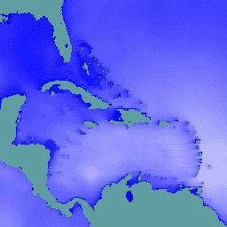
// Observe the ocean in the vicinity of the Caribbean islands and\n// Gulf coast.\nvar aoi = ee.Geometry.Polygon(\n [[\n [-100.6052734375, 31.751243295508836],\n [-100.6052734375, 6.080143483787566],\n [-57.18730468750001, 6.080143483787566],\n [-57.18730468750001, 31.751243295508836]\n ]],\n null, false);\n\n// Extract significant wave height forecasts made at noon on 2025/6/11.\nvar wave =\n ee.ImageCollection('ECMWF/NRT_FORECAST/IFS/WAVE')\n .filter(ee.Filter.eq('creation_doy', 162))\n .filter(ee.Filter.eq('creation_hour', 12))\n .sort('forecast_hours')\n .select('significant_height_of_combined_wind_waves_and_swell_sfc');\n\n// Display the observations at forecast hour 0 on the map.\nvar hour0 = wave.first().clip(aoi);\nMap.centerObject(hour0);\nMap.addLayer(hour0, {min: 0, max: 5}, 'sig height fc=0');\n\n// Animate the wave height forecasts over time.\nvar videoArgs = {\n dimensions: 540,\n region: aoi,\n framesPerSecond: 7,\n crs: 'EPSG:3857',\n min: 0,\n max: 5,\n};\nprint(ui.Thumbnail(wave, videoArgs));\n```\n[Open in Code Editor](https://code.earthengine.google.com/?scriptPath=Examples:Datasets/ECMWF/ECMWF_NRT_FORECAST_IFS_SCWV) \n[ECMWF Near-Realtime IFS Wave (Short-Cutoff) Forecasts](/earth-engine/datasets/catalog/ECMWF_NRT_FORECAST_IFS_SCWV) \nThis dataset contains 6-day forecasts of the wave model fields generated by the ECMWF Integrated Forecasting System (IFS) at 0.25 degree resolution. We refer to these as Near-Realtime (NRT) because new products are released twice a day after the release of the ECMWF realtime forecast data, of which this is ... \nECMWF/NRT_FORECAST/IFS/SCWV, climate,ecmwf,forecast,global,ocean \n2024-11-12T18:00:00Z/2025-09-01T06:00:00Z \n-90 -180 90 180 \nGoogle Earth Engine \nhttps://developers.google.com/earth-engine/datasets\n\n- [https://doi.org/10.21957/open-data](https://doi.org/https://www.ecmwf.int/en/forecasts/datasets/open-data)\n- [https://doi.org/10.21957/open-data](https://doi.org/https://developers.google.com/earth-engine/datasets/catalog/ECMWF_NRT_FORECAST_IFS_SCWV)"]]