Set data ini berisi perkiraan 15 hari untuk kolom model gelombang
yang dihasilkan oleh Sistem Perkiraan Terintegrasi (IFS) ECMWF pada resolusi
0,25 derajat. Kami menyebutnya Near-Realtime (NRT) karena produk baru dirilis dua kali sehari setelah rilis data perkiraan real-time ECMWF, yang merupakan subset dari produk ini. Data dapat didistribusikan dan digunakan secara komersial dengan atribusi yang tepat.
Produk tersedia di Earth Engine mulai dengan penerapan
Cycle 49r1
pada 12-11-2024; produk sebelumnya tidak disertakan. Untuk informasi umum
tentang cara menggunakan set data NRT ECMWF, lihat
dokumentasi pengguna mereka.
File sumber tersedia di
Google Cloud Marketplace.
Band
Ukuran Piksel 28.000 meter
Band
Nama
Unit
Min
Maks
Ukuran Piksel
Deskripsi
mean_zero_crossing_wave_period_sfc
detik
0.889358*
17,0074*
meter
Rata-rata durasi waktu antara saat permukaan laut/samudra melintasi permukaan laut rata-rata.
Tinggi rata-rata sepertiga gelombang laut/samudra permukaan tertinggi yang dihasilkan oleh angin dan gelombang. Nilai ini mewakili jarak vertikal
antara puncak gelombang dan palung gelombang.
mean_wave_direction_sfc
deg
0
360
meter
Arah rata-rata gelombang permukaan laut/samudra relatif terhadap
lokasi geografis kutub utara (misalnya, 0 berarti "datang dari
utara" dan 90 "datang dari timur").
peak_wave_period_sfc
detik
1.03074*
23,9353*
meter
Periode gelombang laut paling kuat yang dihasilkan oleh angin lokal
dan terkait dengan gelombang laut. Periode gelombang adalah waktu rata-rata yang diperlukan oleh dua puncak gelombang berturut-turut di permukaan samudra/laut untuk melewati titik tetap.
mean_wave_period_sfc
detik
1.04071*
19,5239*
meter
Waktu rata-rata yang diperlukan dua puncak gelombang berturut-turut, di permukaan samudra/laut, untuk melewati titik tetap.
* perkiraan nilai min atau maks
Properti Gambar
Properti Gambar
Nama
Jenis
Deskripsi
creation_day
INT
Hari dalam bulan saat perkiraan dibuat.
creation_doy
INT
Hari dalam setahun saat perkiraan dibuat.
creation_hour
INT
Jam dalam sehari saat perkiraan dibuat.
creation_month
INT
Bulan dalam tahun saat perkiraan dibuat.
creation_time
INT
Waktu, dalam milidetik epoch unix, saat perkiraan dibuat.
creation_year
INT
Tahun saat perkiraan dibuat.
forecast_hours
INT
Jam ke depan, relatif terhadap creation_time, dari perkiraan.
forecast_time
INT
Waktu, dalam milidetik epoch unix, perkiraan.
model
STRING
Model prakiraan ECMWF:
ifs: Integrated Forecasting System
aifs: Artificial Intelligence/Integrated Forecasting System
feed
STRING
Aliran data tempat variabel diambil. Lihat daftar lengkapnya
di sini.
Set data ini berisi perkiraan 15 hari untuk kolom model gelombang yang dihasilkan oleh Sistem Perkiraan Terintegrasi (IFS) ECMWF pada resolusi 0,25 derajat. Kami menyebutnya Near-Realtime (NRT) karena produk baru dirilis dua kali sehari setelah rilis data perkiraan real-time ECMWF, yang …
[null,null,[],[],[],null,["Dataset Availability\n: 2024-11-12T12:00:00Z--2025-08-31T12:00:00Z\n\nDataset Provider\n:\n\n\n [ECMWF](https://www.ecmwf.int/en/forecasts/datasets/open-data)\n\nCadence\n: 12 Hours\n\nTags\n:\n[climate](/earth-engine/datasets/tags/climate) [ecmwf](/earth-engine/datasets/tags/ecmwf) [forecast](/earth-engine/datasets/tags/forecast) [global](/earth-engine/datasets/tags/global) [ocean](/earth-engine/datasets/tags/ocean) \n\nDescription \nThis dataset contains 15-day forecasts of the wave model fields\ngenerated by the ECMWF Integrated Forecasting System (IFS) at 0.25 degree\nresolution. We refer to these as Near-Realtime (NRT) because new products\nare released twice a day after the release of the ECMWF realtime forecast\ndata, of which this is a subset. Data may be distributed and used\ncommercially with\n[proper attribution](https://apps.ecmwf.int/datasets/licences/general/).\n\nProducts are available in Earth Engine starting with the implementation of\n[Cycle 49r1](https://confluence.ecmwf.int/display/FCST/Implementation+of+IFS+Cycle+49r1)\non 2024-11-12; earlier products are not included. For general information\nabout how to use ECMWF NRT datasets, see their\n[user documentation](https://confluence.ecmwf.int/display/DAC/ECMWF+open+data%3A+real-time+forecasts+from+IFS+and+AIFS).\nSources files are available in the\n[Google Cloud marketplace](https://console.cloud.google.com/marketplace/product/bigquery-public-data/open-data-ecmwf).\n\nBands\n\n\n**Pixel Size**\n\n28000 meters\n\n**Bands**\n\n| Name | Units | Min | Max | Pixel Size | Description |\n|-----------------------------------------------------------|---------|-------------|-----------|------------|------------------------------------------------------------------------------------------------------------------------------------------------------------------------------------------------------------------------------------------------|\n| `mean_zero_crossing_wave_period_sfc` | seconds | 0.889358\\* | 17.0074\\* | meters | The mean length of time between occasions where the sea/ocean surface crosses mean sea level. |\n| `significant_height_of_combined_wind_waves_and_swell_sfc` | m | 0.0172079\\* | 15.7469\\* | meters | The average height of the highest third of surface ocean/sea waves generated by wind and swell. It represents the vertical distance between the wave crest and the wave trough. |\n| `mean_wave_direction_sfc` | deg | 0 | 360 | meters | The mean direction of ocean/sea surface waves relative to the geographic location of the north pole (e.g., 0 means \"coming from the north\" and 90 \"coming from the east\"). |\n| `peak_wave_period_sfc` | seconds | 1.03074\\* | 23.9353\\* | meters | The period of the most energetic ocean waves generated by local winds and associated with swell. The wave period is the average time it takes for two consecutive wave crests, on the surface of the ocean/sea, to pass through a fixed point. |\n| `mean_wave_period_sfc` | seconds | 1.04071\\* | 19.5239\\* | meters | The average time it takes for two consecutive wave crests, on the surface of the ocean/sea, to pass through a fixed point. |\n\n\\* estimated min or max value\n\nImage Properties\n\n**Image Properties**\n\n| Name | Type | Description |\n|----------------|--------|---------------------------------------------------------------------------------------------------------------------------------|\n| creation_day | INT | Day of the month when the forecast was created. |\n| creation_doy | INT | Day of the year when the forecast was created. |\n| creation_hour | INT | Hour of the day when the forecast was created. |\n| creation_month | INT | Month of the year when the forecast was created. |\n| creation_time | INT | Time, in unix epoch milliseconds, when forecast was created. |\n| creation_year | INT | Year when the forecast was created. |\n| forecast_hours | INT | Hours into the future, relative to `creation_time`, of the forecast. |\n| forecast_time | INT | Time, in unix epoch milliseconds, of the forecast. |\n| model | STRING | The ECMWF forecasting model: - ifs: Integrated Forecasting System - aifs: Artificial Intelligence/Integrated Forecasting System |\n| stream | STRING | The stream from which the variables were fetched. See the full list [here](https://codes.ecmwf.int/grib/format/mars/stream/). |\n\nTerms of Use\n\n**Terms of Use**\n\n[CC-BY-4.0](https://spdx.org/licenses/CC-BY-4.0.html)\n\nDOIs\n\n- \u003chttps://doi.org/10.21957/open-data\u003e\n\nExplore with Earth Engine **Important:** Earth Engine is a platform for petabyte-scale scientific analysis and visualization of geospatial datasets, both for public benefit and for business and government users. Earth Engine is free to use for research, education, and nonprofit use. To get started, please [register for Earth Engine access.](https://console.cloud.google.com/earth-engine)\n\nCode Editor (JavaScript) \n\n```javascript\n
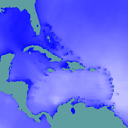
// Observe the ocean in the vicinity of the Caribbean islands and\n// Gulf coast.\nvar aoi = ee.Geometry.Polygon(\n [[\n [-100.6052734375, 31.751243295508836],\n [-100.6052734375, 6.080143483787566],\n [-57.18730468750001, 6.080143483787566],\n [-57.18730468750001, 31.751243295508836]\n ]],\n null, false);\n\n// Extract significant wave height forecasts made at noon on 2025/6/11.\nvar wave =\n ee.ImageCollection('ECMWF/NRT_FORECAST/IFS/WAVE')\n .filter(ee.Filter.eq('creation_doy', 162))\n .filter(ee.Filter.eq('creation_hour', 12))\n .sort('forecast_hours')\n .select('significant_height_of_combined_wind_waves_and_swell_sfc');\n\n// Display the observations at forecast hour 0 on the map.\nvar hour0 = wave.first().clip(aoi);\nMap.centerObject(hour0);\nMap.addLayer(hour0, {min: 0, max: 5}, 'sig height fc=0');\n\n// Animate the wave height forecasts over time.\nvar videoArgs = {\n dimensions: 540,\n region: aoi,\n framesPerSecond: 7,\n crs: 'EPSG:3857',\n min: 0,\n max: 5,\n};\nprint(ui.Thumbnail(wave, videoArgs));\n```\n[Open in Code Editor](https://code.earthengine.google.com/?scriptPath=Examples:Datasets/ECMWF/ECMWF_NRT_FORECAST_IFS_WAVE) \n[ECMWF Near-Realtime IFS Wave Forecasts](/earth-engine/datasets/catalog/ECMWF_NRT_FORECAST_IFS_WAVE) \nThis dataset contains 15-day forecasts of the wave model fields generated by the ECMWF Integrated Forecasting System (IFS) at 0.25 degree resolution. We refer to these as Near-Realtime (NRT) because new products are released twice a day after the release of the ECMWF realtime forecast data, of which this is ... \nECMWF/NRT_FORECAST/IFS/WAVE, climate,ecmwf,forecast,global,ocean \n2024-11-12T12:00:00Z/2025-08-31T12:00:00Z \n-90 -180 90 180 \nGoogle Earth Engine \nhttps://developers.google.com/earth-engine/datasets\n\n- [https://doi.org/10.21957/open-data](https://doi.org/https://www.ecmwf.int/en/forecasts/datasets/open-data)\n- [https://doi.org/10.21957/open-data](https://doi.org/https://developers.google.com/earth-engine/datasets/catalog/ECMWF_NRT_FORECAST_IFS_WAVE)"]]