Этот набор данных содержит 15-дневные прогнозы полей волновых моделей, созданные Интегрированной системой прогнозирования (IFS) ЕЦСПП с разрешением 0,25 градуса. Мы называем их прогнозами в режиме, близком к реальному времени (NRT), поскольку новые продукты выпускаются дважды в день после публикации данных прогнозов ЕЦСПП в реальном времени, подмножеством которых является этот набор. Данные могут распространяться и использоваться в коммерческих целях с указанием авторства .
Продукты доступны в Earth Engine, начиная с реализации Cycle 49r1 12 ноября 2024 г.; более ранние продукты не включены. Общую информацию об использовании наборов данных ECMWF NRT см. в пользовательской документации . Исходные файлы доступны в Google Cloud Marketplace .
Группы
Размер пикселя 28000 метров
Группы
Имя
Единицы
Мин.
Макс
Размер пикселя
Описание
mean_zero_crossing_wave_period_sfc
секунды
0,889358*
17.0074*
метров
Средний промежуток времени между моментами пересечения поверхностью моря/океана среднего уровня моря.
Средняя высота самой высокой трети поверхностных океанских/морских волн, создаваемых ветром и зыбью. Она представляет собой вертикальное расстояние между гребнем и подошвой волны.
mean_wave_direction_sfc
град
0
360
метров
Среднее направление поверхностных волн океана/моря относительно географического положения Северного полюса (например, 0 означает «приходящий с севера», а 90 — «приходящий с востока»).
peak_wave_period_sfc
секунды
1.03074*
23.9353*
метров
Период наиболее энергичных океанских волн, создаваемых местными ветрами и связанных с зыбью. Период волны — это среднее время, необходимое двум последовательным гребням волны на поверхности океана/моря для прохождения через фиксированную точку.
mean_wave_period_sfc
секунды
1.04071*
19.5239*
метров
Среднее время, необходимое двум последовательным гребням волн на поверхности океана/моря для прохождения через фиксированную точку.
* расчетное минимальное или максимальное значение
Свойства изображения
Имя
Тип
Описание
день_сотворения
ИНТ
День месяца, когда был создан прогноз.
creation_doy
ИНТ
День года, когда был создан прогноз.
время_создания
ИНТ
Час дня, когда был создан прогноз.
месяц_создания
ИНТ
Месяц года, когда был создан прогноз.
время_создания
ИНТ
Время создания прогноза (в миллисекундах эпохи Unix).
год_сотворения
ИНТ
Год создания прогноза.
прогноз_часов
ИНТ
Часы в будущем относительно creation_time прогноза.
прогноз_времени
ИНТ
Время прогноза в миллисекундах эпохи Unix.
модель
НИТЬ
Модель прогнозирования ЕЦСПП:
ifs: Интегрированная система прогнозирования
aifs: Искусственный интеллект/Интегрированная система прогнозирования
транслировать
НИТЬ
Поток, из которого были извлечены переменные. Полный список см. здесь .
Этот набор данных содержит 15-дневные прогнозы полей волновых моделей, созданные Интегрированной системой прогнозирования (IFS) ЕЦСПП с разрешением 0,25 градуса. Мы называем их прогнозами в режиме, близком к реальному времени (NRT), поскольку новые продукты выпускаются дважды в день после публикации данных ECMWF о прогнозах в реальном времени, из которых…
[null,null,[],[],[],null,["Dataset Availability\n: 2024-11-12T12:00:00Z--2025-08-31T12:00:00Z\n\nDataset Provider\n:\n\n\n [ECMWF](https://www.ecmwf.int/en/forecasts/datasets/open-data)\n\nCadence\n: 12 Hours\n\nTags\n:\n[climate](/earth-engine/datasets/tags/climate) [ecmwf](/earth-engine/datasets/tags/ecmwf) [forecast](/earth-engine/datasets/tags/forecast) [global](/earth-engine/datasets/tags/global) [ocean](/earth-engine/datasets/tags/ocean) \n\nDescription \nThis dataset contains 15-day forecasts of the wave model fields\ngenerated by the ECMWF Integrated Forecasting System (IFS) at 0.25 degree\nresolution. We refer to these as Near-Realtime (NRT) because new products\nare released twice a day after the release of the ECMWF realtime forecast\ndata, of which this is a subset. Data may be distributed and used\ncommercially with\n[proper attribution](https://apps.ecmwf.int/datasets/licences/general/).\n\nProducts are available in Earth Engine starting with the implementation of\n[Cycle 49r1](https://confluence.ecmwf.int/display/FCST/Implementation+of+IFS+Cycle+49r1)\non 2024-11-12; earlier products are not included. For general information\nabout how to use ECMWF NRT datasets, see their\n[user documentation](https://confluence.ecmwf.int/display/DAC/ECMWF+open+data%3A+real-time+forecasts+from+IFS+and+AIFS).\nSources files are available in the\n[Google Cloud marketplace](https://console.cloud.google.com/marketplace/product/bigquery-public-data/open-data-ecmwf).\n\nBands\n\n\n**Pixel Size**\n\n28000 meters\n\n**Bands**\n\n| Name | Units | Min | Max | Pixel Size | Description |\n|-----------------------------------------------------------|---------|-------------|-----------|------------|------------------------------------------------------------------------------------------------------------------------------------------------------------------------------------------------------------------------------------------------|\n| `mean_zero_crossing_wave_period_sfc` | seconds | 0.889358\\* | 17.0074\\* | meters | The mean length of time between occasions where the sea/ocean surface crosses mean sea level. |\n| `significant_height_of_combined_wind_waves_and_swell_sfc` | m | 0.0172079\\* | 15.7469\\* | meters | The average height of the highest third of surface ocean/sea waves generated by wind and swell. It represents the vertical distance between the wave crest and the wave trough. |\n| `mean_wave_direction_sfc` | deg | 0 | 360 | meters | The mean direction of ocean/sea surface waves relative to the geographic location of the north pole (e.g., 0 means \"coming from the north\" and 90 \"coming from the east\"). |\n| `peak_wave_period_sfc` | seconds | 1.03074\\* | 23.9353\\* | meters | The period of the most energetic ocean waves generated by local winds and associated with swell. The wave period is the average time it takes for two consecutive wave crests, on the surface of the ocean/sea, to pass through a fixed point. |\n| `mean_wave_period_sfc` | seconds | 1.04071\\* | 19.5239\\* | meters | The average time it takes for two consecutive wave crests, on the surface of the ocean/sea, to pass through a fixed point. |\n\n\\* estimated min or max value\n\nImage Properties\n\n**Image Properties**\n\n| Name | Type | Description |\n|----------------|--------|---------------------------------------------------------------------------------------------------------------------------------|\n| creation_day | INT | Day of the month when the forecast was created. |\n| creation_doy | INT | Day of the year when the forecast was created. |\n| creation_hour | INT | Hour of the day when the forecast was created. |\n| creation_month | INT | Month of the year when the forecast was created. |\n| creation_time | INT | Time, in unix epoch milliseconds, when forecast was created. |\n| creation_year | INT | Year when the forecast was created. |\n| forecast_hours | INT | Hours into the future, relative to `creation_time`, of the forecast. |\n| forecast_time | INT | Time, in unix epoch milliseconds, of the forecast. |\n| model | STRING | The ECMWF forecasting model: - ifs: Integrated Forecasting System - aifs: Artificial Intelligence/Integrated Forecasting System |\n| stream | STRING | The stream from which the variables were fetched. See the full list [here](https://codes.ecmwf.int/grib/format/mars/stream/). |\n\nTerms of Use\n\n**Terms of Use**\n\n[CC-BY-4.0](https://spdx.org/licenses/CC-BY-4.0.html)\n\nDOIs\n\n- \u003chttps://doi.org/10.21957/open-data\u003e\n\nExplore with Earth Engine **Important:** Earth Engine is a platform for petabyte-scale scientific analysis and visualization of geospatial datasets, both for public benefit and for business and government users. Earth Engine is free to use for research, education, and nonprofit use. To get started, please [register for Earth Engine access.](https://console.cloud.google.com/earth-engine)\n\nCode Editor (JavaScript) \n\n```javascript\n
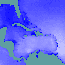
// Observe the ocean in the vicinity of the Caribbean islands and\n// Gulf coast.\nvar aoi = ee.Geometry.Polygon(\n [[\n [-100.6052734375, 31.751243295508836],\n [-100.6052734375, 6.080143483787566],\n [-57.18730468750001, 6.080143483787566],\n [-57.18730468750001, 31.751243295508836]\n ]],\n null, false);\n\n// Extract significant wave height forecasts made at noon on 2025/6/11.\nvar wave =\n ee.ImageCollection('ECMWF/NRT_FORECAST/IFS/WAVE')\n .filter(ee.Filter.eq('creation_doy', 162))\n .filter(ee.Filter.eq('creation_hour', 12))\n .sort('forecast_hours')\n .select('significant_height_of_combined_wind_waves_and_swell_sfc');\n\n// Display the observations at forecast hour 0 on the map.\nvar hour0 = wave.first().clip(aoi);\nMap.centerObject(hour0);\nMap.addLayer(hour0, {min: 0, max: 5}, 'sig height fc=0');\n\n// Animate the wave height forecasts over time.\nvar videoArgs = {\n dimensions: 540,\n region: aoi,\n framesPerSecond: 7,\n crs: 'EPSG:3857',\n min: 0,\n max: 5,\n};\nprint(ui.Thumbnail(wave, videoArgs));\n```\n[Open in Code Editor](https://code.earthengine.google.com/?scriptPath=Examples:Datasets/ECMWF/ECMWF_NRT_FORECAST_IFS_WAVE) \n[ECMWF Near-Realtime IFS Wave Forecasts](/earth-engine/datasets/catalog/ECMWF_NRT_FORECAST_IFS_WAVE) \nThis dataset contains 15-day forecasts of the wave model fields generated by the ECMWF Integrated Forecasting System (IFS) at 0.25 degree resolution. We refer to these as Near-Realtime (NRT) because new products are released twice a day after the release of the ECMWF realtime forecast data, of which this is ... \nECMWF/NRT_FORECAST/IFS/WAVE, climate,ecmwf,forecast,global,ocean \n2024-11-12T12:00:00Z/2025-08-31T12:00:00Z \n-90 -180 90 180 \nGoogle Earth Engine \nhttps://developers.google.com/earth-engine/datasets\n\n- [https://doi.org/10.21957/open-data](https://doi.org/https://www.ecmwf.int/en/forecasts/datasets/open-data)\n- [https://doi.org/10.21957/open-data](https://doi.org/https://developers.google.com/earth-engine/datasets/catalog/ECMWF_NRT_FORECAST_IFS_WAVE)"]]