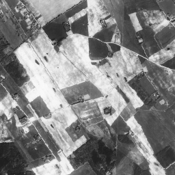
Ортофотоснимки — это набор данных аэрофотоснимков, охватывающих территорию Эстонии.
Ортофотоснимок — это обработанный аэрофотоснимок, из которого удалены искажения, вызванные рельефом местности, наклоном камеры относительно земли в момент съёмки и центральной проекцией камеры. Цифровой ортофотоснимок имеет определённый размер пикселя или разрешение, которое показывает наименьшую неделимую экспонированную область на земной поверхности (Ground Sampling Distance, GSD).
Ортофотоснимки имеют общенациональное покрытие и соответствуют масштабу 1:5000–1:10000 (размер пикселя 20–40 см). Ортофотоснимки густонаселённых территорий производятся с размером пикселя 10–16 см.
Мононабор данных имеет одну полосу оттенков серого с охватом всей страны.
Данные можно свободно использовать в коммерческих и некоммерческих целях в течение неопределенного срока при условии указания лицензиара (например, Земельного департамента Эстонии) с указанием названия и возраста данных.
Ортофотоснимки — это набор данных аэрофотоснимков, охватывающих Эстонию. Ортофотоснимок — это обработанный аэрофотоснимок, из которого удалены искажения, вызванные рельефом местности, наклоном камеры относительно земли в момент съёмки и центральной проекцией камеры. Цифровой ортофотоснимок имеет определённый размер пикселя или разрешение, которое…
[null,null,[],[[["\u003cp\u003eThe Estonia Maamet orthos/mono dataset provides orthophotos covering Estonia from 1993 to 2021.\u003c/p\u003e\n"],["\u003cp\u003eOrthophotos are aerial photos corrected for distortions, offering a detailed view of the terrain.\u003c/p\u003e\n"],["\u003cp\u003eThe dataset has a nationwide coverage with a resolution of 0.4 meters and a single grayscale band.\u003c/p\u003e\n"],["\u003cp\u003eThis data is free for commercial and non-commercial use with proper attribution to the Estonian Land Board.\u003c/p\u003e\n"],["\u003cp\u003eThe dataset can be accessed and analyzed using Google Earth Engine.\u003c/p\u003e\n"]]],[],null,["# Estonia mono orthophotos\n\nDataset Availability\n: 1993-01-01T00:00:00Z--2021-06-16T00:00:00Z\n\nDataset Provider\n:\n\n\n [Estonia orthophotos](https://geoportaal.maaamet.ee/eng/Spatial-Data/Orthophotos-p309.html)\n\nTags\n:\n[estonia](/earth-engine/datasets/tags/estonia) [orthophotos](/earth-engine/datasets/tags/orthophotos) \n\n#### Description\n\nOrthophotos are an aerial photo dataset covering Estonia.\n\nAn orthophoto is a processed aerial photo from which distortions caused\nby terrain relief, camera tilt relative to the ground at the moment of\nexposure and camera central projection are removed. A digital orthophoto\nhas a certain pixel size or resolution which shows the smallest\nindivisible exposed area on the ground (Ground Sampling Distance, GSD).\n\nOrthophotos have a nationwide coverage and correspond to the scale of\n1:5000-1:10000 (pixel size 20-40 cm). Orthophotos for densely-populated\nareas are produced with the pixel size of 10-16 cm.\n\nThe mono dataset has a single grayscale band with nationwide coverage.\n\nFor more information, please see the\n[Estonia orthophotos documentation](https://geoportaal.maaamet.ee/eng/Spatial-Data/Orthophotos-p309.html)\n\n### Bands\n\n\n**Pixel Size**\n\n0.4 meters\n\n**Bands**\n\n| Name | Min | Max | Pixel Size | Description |\n|--------|-----|-----|------------|-------------|\n| `mono` | 0 | 255 | meters | Grayscale |\n\n### Terms of Use\n\n**Terms of Use**\n\nThe data is free to use for commercial and non-commercial purposes for a\nnon-specified term, provided that proper attribution is given to the\nlicensor (e.g. Estonian Land Board) along with the title and age of the\ndata.\n\nFor more details please see the\n[Terms of use](https://geoportaal.maaamet.ee/docs/Avaandmed/Licence-of-open-data-of-Estonian-Land-Board.pdf)\n\n### Citations\n\nCitations:\n\n- Map data: Estonian Land Board\n\n### Explore with Earth Engine\n\n| **Important:** Earth Engine is a platform for petabyte-scale scientific analysis and visualization of geospatial datasets, both for public benefit and for business and government users. Earth Engine is free to use for research, education, and nonprofit use. To get started, please [register for Earth Engine access.](https://console.cloud.google.com/earth-engine)\n\n### Code Editor (JavaScript)\n\n```javascript\nvar dataset = ee.ImageCollection('Estonia/Maamet/orthos/mono');\nMap.setCenter(26.61312, 58.5879, 15);\nMap.addLayer(dataset, null, 'Estonia Maamet mono');\n```\n[Open in Code Editor](https://code.earthengine.google.com/?scriptPath=Examples:Datasets/Estonia/Estonia_Maamet_orthos_mono) \n[Estonia mono orthophotos](/earth-engine/datasets/catalog/Estonia_Maamet_orthos_mono) \nOrthophotos are an aerial photo dataset covering Estonia. An orthophoto is a processed aerial photo from which distortions caused by terrain relief, camera tilt relative to the ground at the moment of exposure and camera central projection are removed. A digital orthophoto has a certain pixel size or resolution which ... \nEstonia/Maamet/orthos/mono, estonia,orthophotos \n1993-01-01T00:00:00Z/2021-06-16T00:00:00Z \n57.3 21.5 59.5 28.1 \nGoogle Earth Engine \nhttps://developers.google.com/earth-engine/datasets\n\n- [](https://doi.org/https://geoportaal.maaamet.ee/eng/Spatial-Data/Orthophotos-p309.html)\n- [](https://doi.org/https://developers.google.com/earth-engine/datasets/catalog/Estonia_Maamet_orthos_mono)"]]