Глобальные слои административных единиц (GAUL) собирают и распространяют наилучшую доступную информацию об административных единицах для всех стран мира, внося вклад в стандартизацию набора пространственных данных, представляющего административные единицы. GAUL всегда поддерживает глобальные слои с единой системой кодирования на уровне страны, первого (например, департаменты) и второго административного уровня (например, районы). При наличии данных он предоставляет слои по странам вплоть до третьего, четвертого и более низких уровней. Общая методология состоит в a) сборе наилучших доступных данных из наиболее надежных источников, b) установлении периодов проверки географических объектов (когда это возможно), c) добавлении выбранных данных в глобальный слой на основе последней карты границ стран, предоставленной Картографическим подразделением ООН (UNCS), d) генерации кодов с использованием Системы кодирования GAUL и e) распространении данных среди пользователей (см. Технические аспекты набора распределения GAUL ). Обратите внимание, что некоторые административные единицы являются многополигональными объектами.
Схема таблицы
Схема таблицы
Имя
Тип
Описание
ADM0_CODE
ИНТ
код страны ГАЛИЯ
ADM0_NAME
НИТЬ
Название страны ООН
DISP_AREA
НИТЬ
Незаселенная территория: «Да» или «Нет»
СТАТУС
НИТЬ
Статус страны
Shape_Area
ДВОЙНОЙ
Площадь формы
Shape_Leng
ДВОЙНОЙ
Длина формы
ADM1_CODE
ИНТ
ГАЛЛИЯ код административных единиц первого уровня
ADM1_NAME
НИТЬ
Наименование административных единиц первого уровня
EXP1_YEAR
ИНТ
Год истечения срока действия административной единицы
STR1_YEAR
ИНТ
Год создания административной единицы
Условия эксплуатации
Набор данных GAUL распространяется среди Организации Объединенных Наций и других уполномоченных международных и национальных организаций/агентств. ФАО предоставляет лицензию на использование, скачивание и печать материалов, содержащихся в наборе данных GAUL, исключительно в некоммерческих целях и в соответствии с условиями, указанными в лицензии на данные. Полный документ о лицензии на данные GAUL доступен для скачивания. См. также отказ от ответственности .
Эта версия набора данных GAUL упрощена до 500 м. Глобальные слои административных единиц (GAUL) собирают и распространяют наилучшую доступную информацию об административных единицах всех стран мира, внося вклад в стандартизацию набора пространственных данных, представляющих административные единицы. GAUL постоянно поддерживает глобальный…
FAO/GAUL_SIMPLIFIED_500m/2015/level1, границы, департаменты, ФАО, Галлия, инфраструктура-границы, провинции, штаты, таблица, ООН
[null,null,[],[[["\u003cp\u003eThe FAO GAUL dataset provides global administrative unit boundaries at country, first (e.g., departments), and second administrative levels (e.g., districts).\u003c/p\u003e\n"],["\u003cp\u003eThis specific dataset is a simplified 500m resolution version of the 2015 GAUL data.\u003c/p\u003e\n"],["\u003cp\u003eIt includes attributes like administrative unit codes, names, status, and creation/expiry years.\u003c/p\u003e\n"],["\u003cp\u003eThe data is intended for non-commercial use and is subject to the GAUL Data License.\u003c/p\u003e\n"],["\u003cp\u003eEarth Engine provides tools to explore and analyze this dataset for research and educational purposes.\u003c/p\u003e\n"]]],["The Global Administrative Unit Layers (GAUL) dataset, simplified to 500m resolution, provides administrative unit data for all countries. It's sourced from FAO UN and accessible via Google Earth Engine. The dataset maintains unified coding and includes country, first-level (e.g., departments), and second-level (e.g., districts) administrative units. Users can access and download it for non-commercial purposes, in accordance with the GAUL Data License. Key data includes administrative codes, names, and temporal information like creation and expiry years.\n"],null,["# FAO GAUL 500m Simplified: Global Administrative Unit Layers 2015, First-Level Administrative Units\n\nDataset Availability\n: 2014-12-19T16:45:00Z--2014-12-19T16:45:00Z\n\nDataset Provider\n:\n\n\n [FAO UN](http://www.fao.org/geonetwork/srv/en/metadata.show?id=12691)\n\nTags\n:\n[borders](/earth-engine/datasets/tags/borders) [departments](/earth-engine/datasets/tags/departments) [fao](/earth-engine/datasets/tags/fao) [gaul](/earth-engine/datasets/tags/gaul) [infrastructure-boundaries](/earth-engine/datasets/tags/infrastructure-boundaries) [provinces](/earth-engine/datasets/tags/provinces) [states](/earth-engine/datasets/tags/states) [table](/earth-engine/datasets/tags/table) [un](/earth-engine/datasets/tags/un) \n\n#### Description\n\nThis version of GAUL dataset is simplified at 500m.\n\nThe Global Administrative Unit Layers (GAUL) compiles and disseminates the\nbest available information on administrative units for all the countries in\nthe world, providing a contribution to the standardization of the spatial\ndataset representing administrative units. The GAUL always maintains global\nlayers with a unified coding system at country, first (e.g. departments),\nand second administrative levels (e.g. districts). Where data is available,\nit provides layers on a country by country basis down to third, fourth, and\nlowers levels. The overall methodology consists in a) collecting the best\navailable data from most reliable sources, b) establishing validation\nperiods of the geographic features (when possible), c) adding selected data\nto the global layer based on the last country boundaries map provided by\nthe UN Cartographic Unit (UNCS), d) generating codes using GAUL Coding\nSystem, and e) distribute data to the users\n(see [Technical Aspects of the GAUL Distribution Set](https://sgst.wr.usgs.gov/gfsad30/FAO_GUAL/TechnicalAspectsGAUL2015_Doc1.pdf)).\nNote that some administrative units are multipolygon features.\n\n### Table Schema\n\n**Table Schema**\n\n| Name | Type | Description |\n|------------|--------|--------------------------------------------------|\n| ADM0_CODE | INT | GAUL country code |\n| ADM0_NAME | STRING | UN country name |\n| DISP_AREA | STRING | Unsettled territory: 'Yes' or 'No' |\n| STATUS | STRING | Status of the country |\n| Shape_Area | DOUBLE | Shape area |\n| Shape_Leng | DOUBLE | Shape length |\n| ADM1_CODE | INT | GAUL code of administrative units at first level |\n| ADM1_NAME | STRING | Name of administrative units at first level |\n| EXP1_YEAR | INT | Expiry year of the administrative unit |\n| STR1_YEAR | INT | Creation year of the administrative unit |\n\n### Terms of Use\n\n**Terms of Use**\n\nThe GAUL dataset is distributed to the United Nations and other authorized\ninternational and national institutions/agencies. FAO grants a license to\nuse, download and print the materials contained in the GAUL dataset solely\nfor non-commercial purposes and in accordance with the conditions specified\nin the data license.\n[The full GAUL Data License document](https://developers.google.com/earth-engine/datasets/catalog/DataLicenseGAUL2015.pdf)\nis available for downloading. See also\n[the disclaimer](https://developers.google.com/earth-engine/datasets/catalog/DisclaimerGAUL2015.pdf).\n\n### Explore with Earth Engine\n\n| **Important:** Earth Engine is a platform for petabyte-scale scientific analysis and visualization of geospatial datasets, both for public benefit and for business and government users. Earth Engine is free to use for research, education, and nonprofit use. To get started, please [register for Earth Engine access.](https://console.cloud.google.com/earth-engine)\n\n### Code Editor (JavaScript)\n\n```javascript\n
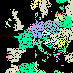
var dataset = ee.FeatureCollection('FAO/GAUL_SIMPLIFIED_500m/2015/level1');\n\nMap.setCenter(7.82, 49.1, 4);\n\nvar styleParams = {\n fillColor: 'b5ffb4',\n color: '00909F',\n width: 1.0,\n};\n\ndataset = dataset.style(styleParams);\n\nMap.addLayer(dataset, {}, 'First Level Administrative Units');\n```\n[Open in Code Editor](https://code.earthengine.google.com/?scriptPath=Examples:Datasets/FAO/FAO_GAUL_SIMPLIFIED_500m_2015_level1) \n[FAO GAUL 500m Simplified: Global Administrative Unit Layers 2015, First-Level Administrative Units](/earth-engine/datasets/catalog/FAO_GAUL_SIMPLIFIED_500m_2015_level1) \nThis version of GAUL dataset is simplified at 500m. The Global Administrative Unit Layers (GAUL) compiles and disseminates the best available information on administrative units for all the countries in the world, providing a contribution to the standardization of the spatial dataset representing administrative units. The GAUL always maintains global ... \nFAO/GAUL_SIMPLIFIED_500m/2015/level1, borders,departments,fao,gaul,infrastructure-boundaries,provinces,states,table,un \n2014-12-19T16:45:00Z/2014-12-19T16:45:00Z \n-90 -180 90 180 \nGoogle Earth Engine \nhttps://developers.google.com/earth-engine/datasets\n\n- [](https://doi.org/http://www.fao.org/geonetwork/srv/en/metadata.show?id=12691)\n- [](https://doi.org/https://developers.google.com/earth-engine/datasets/catalog/FAO_GAUL_SIMPLIFIED_500m_2015_level1)"]]