- Dostępność zbioru danych
- 1992-01-01T00:00:00Z–2018-01-01T00:00:00Z
- Dostawca zbioru danych
- FAO UN
- Cykl
- 1 rok
- Tagi
Opis
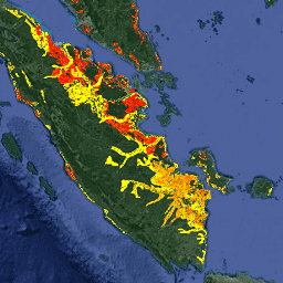
Dwa powiązane zbiory danych FAO dotyczące osuszonych gleb organicznych zawierają szacunki:
DROSA-A: obszar gleb organicznych (w hektarach) osuszonych na potrzeby działalności rolniczej (grunty orne i pastwiska).
DROSE-A: szacunki dotyczące węgla (C) i podtlenku azotu (N2O) (w gigagramach) pochodzące z odpływu wody z gleb organicznych na obszarach rolniczych o tym przeznaczeniu.
Dane roczne są dostępne w rozdzielczości 0,0083333 × 0,0083333 (ok. 1 km na równiku) i obejmują cały świat w latach 1992–2018.
Szacunki FAOSTAT są zgodne z wytycznymi Międzyrządowego Zespołu ds. Zmian Klimatu (IPCC) i wykorzystują histosole jako przybliżone dane dotyczące występowania gleb organicznych oraz roczne mapy pokrycia terenu jako komponent zależny od czasu. Dodatkowo w analizie uwzględniane są charakterystyka gleb, wykorzystanie gruntów i informacje o klimacie. Emisję dwutlenku węgla można przeliczyć na CO2, mnożąc wartości pikseli przez stosunek masy cząsteczkowej dwutlenku węgla (CO2) do masy cząsteczkowej C (44/12).
Gleby organiczne powstają w ekosystemach gleb podmokłych. Obejmują one tropikalne i borealne torfowiska, bagna na wysokich szerokościach geograficznych, paprocie i mokradła. Gleby organiczne pokrywają zaledwie 3% powierzchni lądowej na świecie, ale stanowią do 30% całkowitej ilości węgla w glebie, dlatego odgrywają ważną rolę w utrzymaniu równowagi węglowej na Ziemi. Rolnictwo jest główną przyczyną odwadniania gleb organicznych na całym świecie. Drenaż wystawia materię organiczną gleb organicznych na działanie warunków tlenowych, co powoduje jej utlenianie i uwalnianie do atmosfery dużych ilości szkodliwych gazów cieplarnianych.
DROSA-A i DROSE-A stanowią podstawę statystyk krajowych i regionalnych dotyczących osuszonych gleb organicznych, które są rozpowszechniane w 3 zbiorach danych FAOSTAT (Uprawa gleb organicznych, Grunty orne i Użytki zielone).
Pasma
Rozmiar piksela
927,67 m
Pasma
| Nazwa | Jednostki | Rozmiar piksela | Opis |
|---|---|---|---|
croplandc |
Gg | metry | Emisja C z gleb organicznych na gruntach ornych |
croplandn2o |
Gg | metry | Emisja N2O z gleb organicznych na gruntach ornych |
grasslandc |
Gg | metry | Emisja C z gleb organicznych na użytkach zielonych |
grasslandn2o |
Gg | metry | Emisja N2O z gleb organicznych na użytkach zielonych |
Warunki korzystania z usługi
Warunki korzystania z usługi
Organizacja Narodów Zjednoczonych do spraw Wyżywienia i Rolnictwa (FAO) ma za zadanie zbierać, analizować, interpretować i rozpowszechniać informacje związane z odżywianiem, żywnością i rolnictwem. W tym celu publikuje szereg baz danych dotyczących tematów związanych z mandatem FAO i zachęca do ich wykorzystywania w celach naukowych i badawczych. Zgodnie z zasadami otwartości i udostępniania przewidzianymi w ramach licencji Open Data Licensing For Statistical Databases oraz zgodnie z mandatem FAO dane dotyczące emisji gazów cieplarnianych z działalności rolniczej na glebach organicznych w ramach FAOSTAT – bazy danych FAO dotyczącej danych o żywności i rolnictwie – są dostępne bezpłatnie dla społeczności użytkowników.
Cytaty
FAO 2020. Osuszone gleby organiczne w latach 1990–2019. trendy globalne, regionalne i krajowe; FAOSTAT Analytical Brief Series No 4, FAO, Rzym. http://www.fao.org/3/cb0489en/cb0489en.pdf
Conchedda, G. i Tubiello, F. N.: Drainage of organic soils and GHG emissions: Validation with country data, Earth Syst. Sci. Data Discuss. doi:10.5194/essd-12-3113-2020, 2020
DOI
Odkrywanie za pomocą Earth Engine
Edytor kodu (JavaScript)
var dataset = ee.ImageCollection('FAO/GHG/1/DROSE_A');

var visualization = {
  bands: ['croplandc'],
  min: 0,
  max: 1,
  palette: ['yellow', 'red']
};

Map.setCenter(108.0, -0.4, 6);

Map.addLayer(dataset, visualization, 'Cropland C emissions (Annual)');