- Dostępność zbioru danych
- 2009-01-01T00:00:00Z–2023-03-01T00:00:00Z
- Dostawca zbioru danych
- FAO UN
- Cykl
- 10 dni
- Tagi
Opis
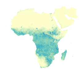
Rzeczywiste parowanie i intercepcja (ETIa) (dekadowe, w mm/dzień) to suma parowania z gleby (E), transpiracji z korony drzew (T) i parowania z opadów deszczu przechwyconych przez liście (I). Wartość każdego piksela reprezentuje średnią dzienną wartość ETIa w danym dekalce.
Pasma
Rozmiar piksela
248,2 m
Pasma
| Nazwa | Jednostki | Skaluj | Rozmiar piksela | Opis |
|---|---|---|---|---|
L1_AETI_D |
mm | 0,1 | metry | Rzeczywiste parowanie i intercepcja (dekada) [mm] |
Warunki korzystania z usługi
Warunki korzystania z usługi
Organizacja Narodów Zjednoczonych do spraw Wyżywienia i Rolnictwa (FAO) ma za zadanie zbierać, analizować, interpretować i rozpowszechniać informacje związane z odżywianiem, żywnością i rolnictwem. W tym celu publikuje szereg baz danych dotyczących tematów związanych z mandatem FAO i zachęca do ich wykorzystywania w celach naukowych i badawczych. Zgodnie z zasadami otwartości i udostępniania, które są podstawą licencji na otwarte dane w przypadku statystycznych baz danych, oraz zgodnie z mandatem FAO dane z portalu Water Productivity Open Access Portal (WaPOR), który jest częścią AQUASTAT – globalnego systemu informacji FAO o wodzie i rolnictwie, są dostępne bezpłatnie dla społeczności użytkowników.
Cytaty
FAO 2018. Metodologia bazy danych WaPOR: poziom 1. Remote Sensing for Water Productivity Technical Report: Methodology Series. Rzym, FAO. 72 strony.
FAO 2020. WaPOR V2 Database Methodology. Remote Sensing for Water Productivity Technical Report: Methodology Series. Rzym, FAO. https://www.fao.org/3/ca9894en/CA9894EN.pdf
Odkrywanie za pomocą Earth Engine
Edytor kodu (JavaScript)
var coll = ee.ImageCollection('FAO/WAPOR/2/L1_AETI_D');
var image = coll.first();
Map.setCenter(17.5, 20, 3);
Map.addLayer(image, {min: 0, max: 50});