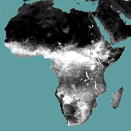
Komponent danych dotyczących parowania (E) (dekadowy, w mm/dzień) to rzeczywiste parowanie z powierzchni gleby. Wartość każdego piksela reprezentuje średnie dzienne rzeczywiste parowanie w danym dekalce.
Pasma
Rozmiar piksela 248,2 m
Pasma
Nazwa
Jednostki
Skaluj
Rozmiar piksela
Opis
L1-E-D
mm
0,1
metry
Parowanie (dekadowe) [mm]
Warunki korzystania z usługi
Organizacja Narodów Zjednoczonych do spraw Wyżywienia i Rolnictwa (FAO) ma za zadanie zbierać, analizować, interpretować i rozpowszechniać informacje związane z odżywianiem, żywnością i rolnictwem. W tym celu publikuje szereg baz danych dotyczących tematów związanych z mandatem FAO i zachęca do ich wykorzystywania w celach naukowych i badawczych. Zgodnie z zasadami otwartości i udostępniania, które są podstawą licencji na otwarte dane w przypadku baz danych statystycznych, oraz zgodnie z mandatem FAO dane z portalu Water Productivity Open Access Portal (WaPOR), który jest częścią AQUASTAT – globalnego systemu informacji FAO o wodzie i rolnictwie, są dostępne bezpłatnie dla społeczności użytkowników.
Cytaty
Cytowania:
FAO 2018. Metodologia bazy danych WaPOR: poziom 1. Remote Sensing for Water
Productivity Technical Report: Methodology Series. Rzym, FAO. 72 strony.
Składnik danych dotyczący parowania (E) (dekadowy, w mm/dzień) to rzeczywiste parowanie z powierzchni gleby. Wartość każdego piksela reprezentuje średnie dzienne rzeczywiste parowanie w danym dekalce.
[null,null,[],[],[],null,["Dataset Availability\n: 2018-01-01T00:00:00Z--2025-08-11T00:00:00Z\n\nDataset Provider\n:\n\n\n [FAO UN](https://www.fao.org/in-action/remote-sensing-for-water-productivity/wapor-data-access/en)\n\nCadence\n: 10 Days\n\nTags\n:\n[agriculture](/earth-engine/datasets/tags/agriculture) [fao](/earth-engine/datasets/tags/fao) [wapor](/earth-engine/datasets/tags/wapor) [water](/earth-engine/datasets/tags/water) [water-vapor](/earth-engine/datasets/tags/water-vapor) \n\nDescription \nThe evaporation (E) data component (dekadal, in mm/day) is the actual\nevaporation of the soil surface. The value of each pixel represents the\naverage daily actual evaporation for that specific dekad.\n\nBands\n\n\n**Pixel Size**\n\n248.2 meters\n\n**Bands**\n\n| Name | Units | Scale | Pixel Size | Description |\n|----------|-------|-------|------------|------------------------------|\n| `L1-E-D` | mm | 0.1 | meters | Evaporation (Dekadal) \\[mm\\] |\n\nTerms of Use\n\n**Terms of Use**\n\nThe Food and Agriculture Organization of the United Nations (FAO) is\nmandated to collect, analyze, interpret, and disseminate information related\nto nutrition, food, and agriculture. In this regard, it publishes a number\nof databases on topics related to FAO's mandate, and encourages the use of\nthem for scientific and research purposes. Consistent with the principles\nof openness and sharing envisioned under the [Open Data Licensing For\nStatistical Databases](http://www.fao.org/3/ca7570en/ca7570en.pdf), and\nconsistent with the mandate of FAO, data from the [Water Productivity Open\nAccess Portal (WaPOR)](https://www.fao.org/in-action/remote-sensing-for-water-productivity/wapor-data-access/en), as part\nof [AQUASTAT](http://www.fao.org/aquastat/en/) - FAO's Global Information\nSystem on Water and Agriculture, is available free to the user community.\n\nCitations \nCitations:\n\n- FAO 2018. WaPOR Database Methodology: Level 1. Remote Sensing for Water\n Productivity Technical Report: Methodology Series. Rome, FAO. 72 pages.\n- FAO 2020. WaPOR V2 Database Methodology. Remote Sensing for Water\n Productivity Technical Report: Methodology Series. Rome, FAO.\n \u003chttps://www.fao.org/3/ca9894en/CA9894EN.pdf\u003e\n\nExplore with Earth Engine **Important:** Earth Engine is a platform for petabyte-scale scientific analysis and visualization of geospatial datasets, both for public benefit and for business and government users. Earth Engine is free to use for research, education, and nonprofit use. To get started, please [register for Earth Engine access.](https://console.cloud.google.com/earth-engine)\n\nCode Editor (JavaScript) \n\n```javascript\nvar coll = ee.ImageCollection('FAO/WAPOR/3/L1_E_D');\nvar image = coll.first();\nMap.setCenter(17.5, 20, 3);\nMap.addLayer(image, {min: 0, max: 10});\n```\n[Open in Code Editor](https://code.earthengine.google.com/?scriptPath=Examples:Datasets/FAO/FAO_WAPOR_3_L1_E_D) \n[WAPOR Dekadal Evaporation 3.0](/earth-engine/datasets/catalog/FAO_WAPOR_3_L1_E_D) \nThe evaporation (E) data component (dekadal, in mm/day) is the actual evaporation of the soil surface. The value of each pixel represents the average daily actual evaporation for that specific dekad. \nFAO/WAPOR/3/L1_E_D, agriculture,fao,wapor,water,water-vapor \n2018-01-01T00:00:00Z/2025-08-11T00:00:00Z \n-90 -180 90 180 \nGoogle Earth Engine \nhttps://developers.google.com/earth-engine/datasets\n\n- [](https://doi.org/https://www.fao.org/in-action/remote-sensing-for-water-productivity/wapor-data-access/en)\n- [](https://doi.org/https://developers.google.com/earth-engine/datasets/catalog/FAO_WAPOR_3_L1_E_D)"]]