Referans bitki buharlaşması (RET), varsayımsal bir referans bitkiden buharlaşma olarak tanımlanır ve iyi sulanmış bir çim yüzeyinin davranışını simüle eder. Her pikselin değeri, söz konusu dekad için günlük referans evapotranspirasyonunun ortalamasını gösterir.
Bantlar
Piksel Boyutu 18.924 metre
Bantlar
Ad
Birimler
Ölçek
Piksel Boyutu
Açıklama
L1-RET-D
mm
0,1
metre
Referans Evapotranspirasyon (Dekadal) [mm]
Kullanım Şartları
Kullanım Şartları
Birleşmiş Milletler Gıda ve Tarım Örgütü (FAO), beslenme, gıda ve tarımla ilgili bilgileri toplamak, analiz etmek, yorumlamak ve yaymakla görevlidir. Bu bağlamda, FAO'nun yetki alanıyla ilgili konularda bir dizi veritabanı yayınlar ve bunların bilimsel ve araştırma amaçlı kullanımını teşvik eder. Open Data Licensing For Statistical Databases (İstatistik Veritabanları İçin Açık Veri Lisanslama) kapsamında öngörülen açıklık ve paylaşım ilkeleriyle tutarlı olarak ve FAO'nun yetkisiyle uyumlu şekilde, AQUASTAT'ın (FAO'nun Su ve Tarım Konusundaki Küresel Bilgi Sistemi) bir parçası olan Water Productivity Open Access Portal (WaPOR)'daki (Su Verimliliği Açık Erişim Portalı) veriler, kullanıcı topluluğuna ücretsiz olarak sunulur.
Alıntılar
Alıntılar:
FAO 2018. WaPOR Database Methodology: Level 1. Remote Sensing for Water
Productivity Technical Report: Methodology Series. Roma, FAO. 72 sayfa.
FAO 2020. WaPOR V2 Veritabanı Metodolojisi. Remote Sensing for Water
Productivity Technical Report: Methodology Series. Rome, FAO.https://www.fao.org/3/ca9894en/CA9894EN.pdf
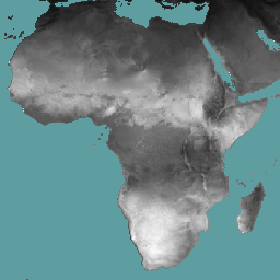
Referans evapotranspirasyon (RET), varsayımsal bir referans mahsulün evapotranspirasyonu olarak tanımlanır ve iyi sulanmış bir çim yüzeyinin davranışını simüle eder. Her pikselin değeri, söz konusu dekad için günlük referans buharlaşmasının ortalamasını gösterir.
[null,null,[],[],[],null,["# WAPOR Dekadal Reference Evapotranspiration 3.0\n\nDataset Availability\n: 2018-01-01T00:00:00Z--2025-08-11T00:00:00Z\n\nDataset Provider\n:\n\n\n [FAO UN](https://www.fao.org/in-action/remote-sensing-for-water-productivity/wapor-data-access/en)\n\nCadence\n: 10 Days\n\nTags\n:\n[agriculture](/earth-engine/datasets/tags/agriculture) [fao](/earth-engine/datasets/tags/fao) [wapor](/earth-engine/datasets/tags/wapor) [water](/earth-engine/datasets/tags/water) [water-vapor](/earth-engine/datasets/tags/water-vapor) \n\n#### Description\n\nReference evapotranspiration (RET) is defined as the evapotranspiration from a\nhypothetical reference crop and it simulates the behaviour of a well-watered\ngrass surface. The value of each pixel represents the average of the daily\nreference evapotranspiration for that specific dekad.\n\n### Bands\n\n\n**Pixel Size**\n\n18924 meters\n\n**Bands**\n\n| Name | Units | Scale | Pixel Size | Description |\n|------------|-------|-------|------------|-----------------------------------------------|\n| `L1-RET-D` | mm | 0.1 | meters | Reference Evapotranspiration (Dekadal) \\[mm\\] |\n\n### Terms of Use\n\n**Terms of Use**\n\nThe Food and Agriculture Organization of the United Nations (FAO) is\nmandated to collect, analyze, interpret, and disseminate information related\nto nutrition, food, and agriculture. In this regard, it publishes a number\nof databases on topics related to FAO's mandate, and encourages the use of\nthem for scientific and research purposes. Consistent with the principles\nof openness and sharing envisioned under the [Open Data Licensing For\nStatistical Databases](http://www.fao.org/3/ca7570en/ca7570en.pdf), and\nconsistent with the mandate of FAO, data from the [Water Productivity Open\nAccess Portal (WaPOR)](https://www.fao.org/in-action/remote-sensing-for-water-productivity/wapor-data-access/en), as part\nof [AQUASTAT](http://www.fao.org/aquastat/en/) - FAO's Global Information\nSystem on Water and Agriculture, is available free to the user community.\n\n### Citations\n\nCitations:\n\n- FAO 2018. WaPOR Database Methodology: Level 1. Remote Sensing for Water \n\n Productivity Technical Report: Methodology Series. Rome, FAO. 72 pages.\n- FAO 2020. WaPOR V2 Database Methodology. Remote Sensing for Water\n Productivity Technical Report: Methodology Series. Rome, FAO.\u003chttps://www.fao.org/3/ca9894en/CA9894EN.pdf\u003e\n\n### Explore with Earth Engine\n\n| **Important:** Earth Engine is a platform for petabyte-scale scientific analysis and visualization of geospatial datasets, both for public benefit and for business and government users. Earth Engine is free to use for research, education, and nonprofit use. To get started, please [register for Earth Engine access.](https://console.cloud.google.com/earth-engine)\n\n### Code Editor (JavaScript)\n\n```javascript\nvar coll = ee.ImageCollection('FAO/WAPOR/3/L1_RET_D');\nvar image = coll.first();\nMap.setCenter(17.5, 20, 3);\nMap.addLayer(image, {min: 0, max: 100});\n```\n[Open in Code Editor](https://code.earthengine.google.com/?scriptPath=Examples:Datasets/FAO/FAO_WAPOR_3_L1_RET_D) \n[WAPOR Dekadal Reference Evapotranspiration 3.0](/earth-engine/datasets/catalog/FAO_WAPOR_3_L1_RET_D) \nReference evapotranspiration (RET) is defined as the evapotranspiration from a hypothetical reference crop and it simulates the behaviour of a well-watered grass surface. The value of each pixel represents the average of the daily reference evapotranspiration for that specific dekad. \nFAO/WAPOR/3/L1_RET_D, agriculture,fao,wapor,water,water-vapor \n2018-01-01T00:00:00Z/2025-08-11T00:00:00Z \n-90 -180 90 180 \nGoogle Earth Engine \nhttps://developers.google.com/earth-engine/datasets\n\n- [](https://doi.org/https://www.fao.org/in-action/remote-sensing-for-water-productivity/wapor-data-access/en)\n- [](https://doi.org/https://developers.google.com/earth-engine/datasets/catalog/FAO_WAPOR_3_L1_RET_D)"]]