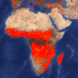
Set data Fire Information for Resource Management System (FIRMS) versi Earth Engine berisi produk deteksi kebakaran LANCE dalam bentuk raster. Lokasi kebakaran aktif yang mendekati real-time (NRT) diproses oleh LANCE menggunakan produk Anomali Termal dan Kebakaran MODIS MOD14/MYD14 standar. Setiap lokasi kebakaran aktif mewakili centroid piksel 1 km yang ditandai oleh algoritma sebagai berisi satu atau beberapa kebakaran dalam piksel tersebut. Data dirasterisasi sebagai berikut: untuk setiap titik kebakaran aktif FIRMS, ditentukan kotak pembatas (BB) 1 km; piksel dalam proyeksi sinusoidal MODIS yang berpotongan dengan BB FIRMS diidentifikasi; jika beberapa BB FIRMS berpotongan dengan piksel yang sama, BB dengan keyakinan yang lebih tinggi akan dipertahankan; jika terjadi kesamaan, BB yang lebih terang akan dipertahankan.
Data dalam set data hampir real-time tidak dianggap memiliki kualitas ilmiah.
Suhu kecerahan piksel api menggunakan saluran MODIS 21/22.
confidence
%
0
100
meter
Keyakinan deteksi yang dimaksudkan untuk membantu pengguna mengukur kualitas piksel api aktif individual. Estimasi keyakinan berkisar antara 0% dan 100% untuk semua piksel kebakaran dalam masker kebakaran. Kolom
keyakinan harus digunakan dengan hati-hati; kemungkinan artinya akan
berbeda di berbagai belahan dunia.
line_number
1*
35302*
meter
Nomor baris dalam file CSV FIRMS tempat piksel berasal.
* perkiraan nilai min atau maks
Persyaratan Penggunaan
NASA mempromosikan pembagian semua data secara penuh dan terbuka dengan komunitas riset dan aplikasi, industri swasta, akademisi, dan masyarakat umum. Baca Kebijakan Data dan Informasi NASA.
Dataset Fire Information for Resource Management System (FIRMS) versi Earth Engine berisi produk deteksi kebakaran LANCE dalam bentuk raster. Lokasi kebakaran aktif yang mendekati real-time (NRT) diproses oleh LANCE menggunakan produk Anomali Kebakaran dan Termal MODIS MOD14/MYD14 standar. Setiap lokasi kebakaran aktif mewakili …
[null,null,[],[[["\u003cp\u003eFIRMS provides near real-time (NRT) active fire data, derived from the MODIS MOD14/MYD14 Fire and Thermal Anomalies product and presented in rasterized form.\u003c/p\u003e\n"],["\u003cp\u003eEach active fire location in the dataset represents the centroid of a 1km pixel flagged by the algorithm as containing one or more fires.\u003c/p\u003e\n"],["\u003cp\u003eThe data are considered to be near real-time and not of science quality, with a confidence estimate provided for each fire pixel.\u003c/p\u003e\n"],["\u003cp\u003eThe dataset covers the period from 2000-11-01 to 2024-12-11 and is provided by NASA/LANCE/EOSDIS.\u003c/p\u003e\n"],["\u003cp\u003eVIIRS FIRMS datasets from NOAA20 and SUOMI are also available as separate datasets within the Earth Engine catalog.\u003c/p\u003e\n"]]],["The Fire Information for Resource Management System (FIRMS) dataset, provided by NASA/LANCE/EOSDIS, contains near real-time active fire locations from 2000-11-01 to 2025-02-22. These fire locations, detected using MODIS data, are rasterized as 1km pixels, with higher confidence and brighter pixels prioritized when multiple fire points overlap. The dataset, accessible via Earth Engine using `ee.ImageCollection(\"FIRMS\")`, includes bands like `T21` (temperature), `confidence` (detection quality), and `line_number` (origin in the data file). The data is not considered science-quality.\n"],null,["Dataset Availability\n: 2000-11-01T00:00:00Z--2025-08-31T00:00:00Z\n\nDataset Provider\n:\n\n\n [NASA / LANCE / EOSDIS](https://earthdata.nasa.gov/earth-observation-data/near-real-time/firms)\n\nCadence\n: 1 Day\n\nTags\n:\n[eosdis](/earth-engine/datasets/tags/eosdis) [fire](/earth-engine/datasets/tags/fire) [firms](/earth-engine/datasets/tags/firms) [geophysical](/earth-engine/datasets/tags/geophysical) [hotspot](/earth-engine/datasets/tags/hotspot) [lance](/earth-engine/datasets/tags/lance) [modis](/earth-engine/datasets/tags/modis) [nasa](/earth-engine/datasets/tags/nasa) [thermal](/earth-engine/datasets/tags/thermal) \n\nDescription \nThe Earth Engine version of the Fire Information for Resource Management\nSystem (FIRMS) dataset contains the LANCE fire detection product in\nrasterized form. The near real-time (NRT) active fire locations are\nprocessed by LANCE using the standard MODIS MOD14/MYD14 Fire and Thermal\nAnomalies product. Each active fire location represents the centroid of a\n1km pixel that is flagged by the algorithm as containing one or more fires\nwithin the pixel. The data are rasterized as follows: for each FIRMS active\nfire point, a 1km bounding box (BB) is defined; pixels in the MODIS\nsinusoidal projection that intersect the FIRMS BB are identified; if\nmultiple FIRMS BBs intersect the same pixel, the one with higher confidence\nis retained; in case of a tie, the brighter one is retained.\n\nThe data in the near-real-time dataset are not considered to be of science\nquality.\n\nAdditional information can be found [here](https://firms.modaps.eosdis.nasa.gov/).\n\nNOTE: VIIRS FIRMS datasets from NOAA20 and SUOMI are also available:\n\n- [NASA/LANCE/NOAA20_VIIRS/C2](/earth-engine/datasets/catalog/NASA_LANCE_NOAA20_VIIRS_C2)\n- [NASA/LANCE/SNPP_VIIRS/C2](/earth-engine/datasets/catalog/NASA_LANCE_SNPP_VIIRS_C2)\n\nBands\n\n\n**Pixel Size**\n\n1000 meters\n\n**Bands**\n\n| Name | Units | Min | Max | Pixel Size | Description |\n|---------------|-------|-------|----------|------------|-----------------------------------------------------------------------------------------------------------------------------------------------------------------------------------------------------------------------------------------------------------------------------------------------------------------------------|\n| `T21` | K | 300\\* | 509.29\\* | meters | The brightness temperature of a fire pixel using MODIS channels 21/22. |\n| `confidence` | % | 0 | 100 | meters | A detection confidence intended to help users gauge the quality of individual active fire pixels. The confidence estimate ranges between 0% and 100% for all fire pixels within the fire mask. The confidence field should be used with caution; it is likely that it will vary in meaning in different parts of the world. |\n| `line_number` | | 1\\* | 35302\\* | meters | Line number in the FIRMS CSV file that the pixel came from. |\n\n\\* estimated min or max value\n\nTerms of Use\n\n**Terms of Use**\n\nNASA promotes the full and open sharing of all data with the research and\napplications communities, private industry, academia, and the general\npublic. Read the [NASA Data and Information Policy](https://www.earthdata.nasa.gov/learn/use-data/data-use-policy).\n\nIf you provide the\n[Land, Atmosphere Near real-time Capability for EOS (LANCE) / Fire Information for Resource Management System (FIRMS)](https://earthdata.nasa.gov/earth-observation-data/near-real-time)\ndata to a third party, follow the guidelines in the\n[LANCE Citation, Acknowledgements, and Disclaimer](https://earthdata.nasa.gov/earth-observation-data/near-real-time/citation#ed-lance-disclaimer)\nsite and replicate or provide a link to the\n[disclaimer](https://earthdata.nasa.gov/earth-observation-data/near-real-time/citation#ed-lance-disclaimer).\n\nCitations \nCitations:\n\n- MODIS Collection 6 NRT Hotspot / Active Fire Detections MCD14DL.\n Available on-line \u003chttps://earthdata.nasa.gov/firms\u003e.\n [doi:10.5067/FIRMS/MODIS/MCD14DL.NRT.006](https://doi.org/10.5067/FIRMS/MODIS/MCD14DL.NRT.006)\n\nExplore with Earth Engine **Important:** Earth Engine is a platform for petabyte-scale scientific analysis and visualization of geospatial datasets, both for public benefit and for business and government users. Earth Engine is free to use for research, education, and nonprofit use. To get started, please [register for Earth Engine access.](https://console.cloud.google.com/earth-engine)\n\nCode Editor (JavaScript) \n\n```javascript\nvar dataset = ee.ImageCollection('FIRMS').filter(\n ee.Filter.date('2018-08-01', '2018-08-10'));\nvar fires = dataset.select('T21');\nvar firesVis = {\n min: 325.0,\n max: 400.0,\n palette: ['red', 'orange', 'yellow'],\n};\nMap.setCenter(-119.086, 47.295, 6);\nMap.addLayer(fires, firesVis, 'Fires');\n```\n[Open in Code Editor](https://code.earthengine.google.com/?scriptPath=Examples:Datasets/FIRMS/FIRMS) \n[FIRMS: Fire Information for Resource Management System](/earth-engine/datasets/catalog/FIRMS) \nThe Earth Engine version of the Fire Information for Resource Management System (FIRMS) dataset contains the LANCE fire detection product in rasterized form. The near real-time (NRT) active fire locations are processed by LANCE using the standard MODIS MOD14/MYD14 Fire and Thermal Anomalies product. Each active fire location represents the ... \nFIRMS, eosdis,fire,firms,geophysical,hotspot,lance,modis,nasa,thermal \n2000-11-01T00:00:00Z/2025-08-31T00:00:00Z \n-90 -180 90 180 \nGoogle Earth Engine \nhttps://developers.google.com/earth-engine/datasets\n\n- [](https://doi.org/https://earthdata.nasa.gov/earth-observation-data/near-real-time/firms)\n- [](https://doi.org/https://developers.google.com/earth-engine/datasets/catalog/FIRMS)"]]