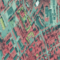
Ортофотоснимки NLS — это набор данных аэрофотоснимков, охватывающий всю территорию Финляндии. Эти данные предоставлены Mavi (Агентством по делам сельской местности) . Ортофотоснимок представляет собой комбинацию нескольких отдельных аэрофотоснимков. Набор данных аэрофотоснимков в формате ортофотоснимков доступен как самый последний набор данных, состоящий из последних доступных аэрофотоснимков. Срок действия последних данных обычно составляет от 1 до 3 лет. Ортофотоснимки NLS обновляются каждые 3 года (в Северной Лапландии — каждые 12 лет).
На этих изображениях полосы представляют собой ближний инфракрасный, красный и зеленый диапазоны.
(В идентификаторе набора данных VV означает «vääräväri», ложный цвет) Для получения дополнительной информации см. документацию по ортофотоснимкам NLS.
Группы
Размер пикселя 0,5 метра
Группы
Имя
Мин.
Макс
Размер пикселя
Описание
N
0
255
метров
Ближний инфракрасный
R
0
255
метров
Красный
G
0
255
метров
Зеленый
Условия эксплуатации
Укажите название Лицензиара (Национальное управление по земельным ресурсам Финляндии), название набора(ов) данных и время, когда Национальное управление по земельным ресурсам Финляндии предоставило набор(ы) данных (например: содержит данные из топографической базы данных Национального управления по земельным ресурсам Финляндии 06/2014). См. Условия использования.
Ортофотоснимки NLS — это набор данных аэрофотоснимков, охватывающих всю территорию Финляндии. Эти данные предоставлены Mavi (Агентством по делам села). Ортофотоснимок представляет собой комбинацию нескольких отдельных аэрофотоснимков. Набор данных аэрофотоснимков в формате ортофотоснимков доступен в виде актуального набора данных, состоящего из самых последних…
[null,null,[],[[["\u003cp\u003eNLS Orthophotos is an aerial photo dataset covering all of Finland, provided by Mavi (Agency for Rural Affairs), and updated every 3 years (12 years in Northern Lapland).\u003c/p\u003e\n"],["\u003cp\u003eThe dataset consists of orthophotos, which are combinations of individual aerial photos, with the most recent data typically being 1-3 years old.\u003c/p\u003e\n"],["\u003cp\u003eImages have a 0.5-meter resolution and include near-infrared, red, and green bands, presented in false color.\u003c/p\u003e\n"],["\u003cp\u003eUsers must acknowledge the National Land Survey of Finland and the dataset name when using the data, adhering to the specified terms of use.\u003c/p\u003e\n"],["\u003cp\u003eThe dataset is available in Google Earth Engine and can be explored for research, education, and nonprofit purposes.\u003c/p\u003e\n"]]],["The NLS Orthophotos dataset, provided by Mavi, covers Finland with aerial photos from 2015 to 2018. It's accessible via Google Earth Engine, using the `ee.ImageCollection(\"Finland/MAVI/VV/50cm\")` snippet. The dataset, updated every 1-12 years, features near-infrared, red, and green bands with a 0.5-meter pixel size. Data users should credit the National Land Survey of Finland and the dataset's name, respecting the provided terms of use.\n"],null,["# Finland NRG NLS orthophotos 50 cm by Mavi\n\nDataset Availability\n: 2015-01-01T00:00:00Z--2018-01-01T00:00:00Z\n\nDataset Provider\n:\n\n\n [NLS orthophotos](https://www.maanmittauslaitos.fi/en/maps-and-spatial-data/expert-users/product-descriptions/orthophotos)\n\nTags\n:\n [falsecolor](/earth-engine/datasets/tags/falsecolor) [finland](/earth-engine/datasets/tags/finland) [nrg](/earth-engine/datasets/tags/nrg) [orthophotos](/earth-engine/datasets/tags/orthophotos) \nmavi \n\n#### Description\n\nNLS Orthophotos are an aerial photo dataset covering the whole of Finland.\nThis data is provided by [Mavi(Agency for Rural Affairs)](https://maaseutuverkosto.fi/en/).\nAn orthophoto is a combination of several individual aerial photos. The\naerial photo dataset in orthophoto format is available as the most recent\ndataset consisting of the most recent aerial photos available. The most\nrecent data is usually 1-3 years old. NLS Orthophotos are updated every\n3 years (in Northern Lapland 12 years).\n\nIn these images, the bands are near-infrared, red, and green.\n\n(In Dataset id, VV stands for \"vääräväri\", false color)\nFor more information, please see the\n[NLS orthophotos documentation](https://www.maanmittauslaitos.fi/en/maps-and-spatial-data/expert-users/product-descriptions/orthophotos)\n\n### Bands\n\n\n**Pixel Size**\n\n0.5 meters\n\n**Bands**\n\n| Name | Min | Max | Pixel Size | Description |\n|------|-----|-----|------------|---------------|\n| `N` | 0 | 255 | meters | Near-Infrared |\n| `R` | 0 | 255 | meters | Red |\n| `G` | 0 | 255 | meters | Green |\n\n### Terms of Use\n\n**Terms of Use**\n\nMention the name of the Licensor (the National Land Survey of Finland),\nthe name of the dataset(s) and the time when the National Land Survey has\ndelivered the dataset(s) (e.g.: contains data from the National Land Survey\nof Finland Topographic Database 06/2014).\nplease see the [Terms of use](https://creativecommons.org/licenses/by/4.0/)\n\n### Citations\n\nCitations:\n\n- The National Land Survey of Finland\n\n### Explore with Earth Engine\n\n| **Important:** Earth Engine is a platform for petabyte-scale scientific analysis and visualization of geospatial datasets, both for public benefit and for business and government users. Earth Engine is free to use for research, education, and nonprofit use. To get started, please [register for Earth Engine access.](https://console.cloud.google.com/earth-engine)\n\n### Code Editor (JavaScript)\n\n```javascript\nvar dataset = ee.ImageCollection('Finland/MAVI/VV/50cm');\n\nMap.setCenter(25.7416, 62.2446, 16);\nMap.addLayer(dataset, null, 'Finland 50 cm(false color)');\n```\n[Open in Code Editor](https://code.earthengine.google.com/?scriptPath=Examples:Datasets/Finland/Finland_MAVI_VV_50cm) \n[Finland NRG NLS orthophotos 50 cm by Mavi](/earth-engine/datasets/catalog/Finland_MAVI_VV_50cm) \nNLS Orthophotos are an aerial photo dataset covering the whole of Finland. This data is provided by Mavi(Agency for Rural Affairs). An orthophoto is a combination of several individual aerial photos. The aerial photo dataset in orthophoto format is available as the most recent dataset consisting of the most recent ... \nFinland/MAVI/VV/50cm, falsecolor,finland,nrg,orthophotos \n2015-01-01T00:00:00Z/2018-01-01T00:00:00Z \n59 18 69.4 29.2 \nGoogle Earth Engine \nhttps://developers.google.com/earth-engine/datasets\n\n- [](https://doi.org/https://www.maanmittauslaitos.fi/en/maps-and-spatial-data/expert-users/product-descriptions/orthophotos)\n- [](https://doi.org/https://developers.google.com/earth-engine/datasets/catalog/Finland_MAVI_VV_50cm)"]]