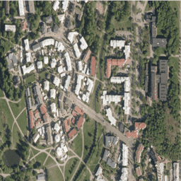
Ortofotomapy NLS to zbiór zdjęć lotniczych obejmujący całą Finlandię.
Źródło danych: SMK(Agencja Energii, wcześniej SMK). Ortofotomapa to połączenie kilku pojedynczych zdjęć lotniczych. Zbiór danych zdjęć lotniczych w formacie ortofotomapy jest dostępny jako najnowszy zbiór danych składający się z najnowszych dostępnych zdjęć lotniczych. Najnowsze dane mają zwykle 1–3 lata. NLS
Ortofotomapy są aktualizowane co 3 lata (w przypadku Laponii Północnej co 12 lat).
(W identyfikatorze zbioru danych litera V oznacza „väri”, czyli „kolor”, w przeciwieństwie do „fałszywego koloru”).
Więcej informacji znajdziesz w dokumentacji ortofotomap NLS.
Pasma
Rozmiar piksela 0,5 metra
Pasma
Nazwa
Minimum
Maks.
Rozmiar piksela
Opis
R
0
255
metry
Czerwony
G
0
255
metry
Zielony
B
0
255
metry
Niebieski
Warunki korzystania z usługi
Wymień nazwę licencjodawcy (Krajowy Urząd Geodezyjny Finlandii), nazwę zbiorów danych i czas, w którym Krajowy Urząd Geodezyjny dostarczył zbiory danych (np. zawiera dane z bazy danych topograficznych Krajowego Urzędu Geodezyjnego Finlandii z czerwca 2014 r.). Więcej informacji znajdziesz w Warunkach korzystania.
Ortofotomapy NLS to zbiór zdjęć lotniczych obejmujący całą Finlandię. Dane te pochodzą z SMK(Agencji Energii, wcześniej SMK). Ortofotomapa to połączenie kilku pojedynczych zdjęć lotniczych. Zestaw danych zdjęć lotniczych w formacie ortofotomapy jest dostępny jako najnowszy zestaw danych składający się z …
[null,null,[],[[["\u003cp\u003eNLS Orthophotos is an aerial dataset covering all of Finland, provided by the National Land Survey of Finland (formerly SMK/The Energy Agency), and updated every 3 years (12 years in Northern Lapland).\u003c/p\u003e\n"],["\u003cp\u003eThe dataset consists of orthophotos, which are combinations of individual aerial photos, in natural color (RGB) with a 0.5-meter resolution.\u003c/p\u003e\n"],["\u003cp\u003eThe data is available from 2015 to 2023 and requires users to acknowledge the National Land Survey of Finland and the dataset name in any publications.\u003c/p\u003e\n"],["\u003cp\u003eUsers can access and analyze the dataset through Google Earth Engine, a platform for geospatial data analysis.\u003c/p\u003e\n"],["\u003cp\u003eThe dataset is licensed under Creative Commons Attribution 4.0 International.\u003c/p\u003e\n"]]],["The NLS Orthophotos dataset, provided by SMK, contains aerial photos of Finland from 2015 to 2023. The dataset, accessible via Google Earth Engine, features RGB bands with a 0.5-meter pixel size. Orthophotos, combining multiple aerial photos, are updated every 3 years. Usage requires citing the National Land Survey of Finland and dataset details, and adhere to the [Terms of use](https://creativecommons.org/licenses/by/4.0/). Data can be explored using Earth Engine's code editor with the provided code snippet.\n"],null,["# Finland RGB NLS orthophotos 50 cm by SMK\n\nDataset Availability\n: 2015-01-01T00:00:00Z--2023-01-01T00:00:00Z\n\nDataset Provider\n:\n\n\n [NLS orthophotos](https://www.maanmittauslaitos.fi/en/maps-and-spatial-data/expert-users/product-descriptions/orthophotos)\n\nTags\n:\n[finland](/earth-engine/datasets/tags/finland) [orthophotos](/earth-engine/datasets/tags/orthophotos) [rgb](/earth-engine/datasets/tags/rgb) [smk](/earth-engine/datasets/tags/smk) \n\n#### Description\n\nNLS Orthophotos are an aerial photo dataset covering the whole of Finland.\nThis data is provided by SMK([The Energy Agency](https://energiavirasto.fi/etusivu),\nformerly abbreviated SMK). An orthophoto is a combination of several\nindividual aerial photos. The aerial photo data set in orthophoto format is\navailable as the most recent data set consisting of the most recent aerial\nphotos available. The most recent data is usually 1-3 years old. NLS\nOrthophotos are updated every 3 years (in Northern Lapland 12 years).\n\n(In Dataset id, V stands for \"väri\", which means \"color\" as opposed to\n\"false color\")\nFor more information, please see the\n[NLS orthophotos documentation](https://www.maanmittauslaitos.fi/en/maps-and-spatial-data/expert-users/product-descriptions/orthophotos)\n\n### Bands\n\n\n**Pixel Size**\n\n0.5 meters\n\n**Bands**\n\n| Name | Min | Max | Pixel Size | Description |\n|------|-----|-----|------------|-------------|\n| `R` | 0 | 255 | meters | Red |\n| `G` | 0 | 255 | meters | Green |\n| `B` | 0 | 255 | meters | Blue |\n\n### Terms of Use\n\n**Terms of Use**\n\nMention the name of the Licensor (the National Land Survey of Finland),\nthe name of the dataset(s) and the time when the National Land Survey has\ndelivered the dataset(s) (e.g.: contains data from the National Land Survey\nof Finland Topographic Database 06/2014).\nplease see the [Terms of use](https://creativecommons.org/licenses/by/4.0/)\n\n### Citations\n\nCitations:\n\n- The National Land Survey of Finland\n\n### Explore with Earth Engine\n\n| **Important:** Earth Engine is a platform for petabyte-scale scientific analysis and visualization of geospatial datasets, both for public benefit and for business and government users. Earth Engine is free to use for research, education, and nonprofit use. To get started, please [register for Earth Engine access.](https://console.cloud.google.com/earth-engine)\n\n### Code Editor (JavaScript)\n\n```javascript\nvar dataset = ee.ImageCollection('Finland/SMK/V/50cm');\n\nMap.setCenter(24.9, 60.2, 17);\nMap.addLayer(dataset, null, 'Finland 50 cm(color)');\n```\n[Open in Code Editor](https://code.earthengine.google.com/?scriptPath=Examples:Datasets/Finland/Finland_SMK_V_50cm) \n[Finland RGB NLS orthophotos 50 cm by SMK](/earth-engine/datasets/catalog/Finland_SMK_V_50cm) \nNLS Orthophotos are an aerial photo dataset covering the whole of Finland. This data is provided by SMK(The Energy Agency, formerly abbreviated SMK). An orthophoto is a combination of several individual aerial photos. The aerial photo data set in orthophoto format is available as the most recent data set consisting ... \nFinland/SMK/V/50cm, finland,orthophotos,rgb,smk \n2015-01-01T00:00:00Z/2023-01-01T00:00:00Z \n59 18 69.4 29.2 \nGoogle Earth Engine \nhttps://developers.google.com/earth-engine/datasets\n\n- [](https://doi.org/https://www.maanmittauslaitos.fi/en/maps-and-spatial-data/expert-users/product-descriptions/orthophotos)\n- [](https://doi.org/https://developers.google.com/earth-engine/datasets/catalog/Finland_SMK_V_50cm)"]]