Global Land Ice Measurements from Space (GLIMS) è
un'iniziativa internazionale con l'obiettivo di rilevare ripetutamente
i circa 200.000 ghiacciai del mondo.
Il progetto mira
a creare un inventario completo a livello globale del ghiaccio terrestre, incluse
misurazioni di area, geometria, velocità superficiale e
altitudine della linea di neve dei ghiacciai. Per eseguire queste analisi, il progetto GLIMS
utilizza dati satellitari, principalmente dell'Advanced Spaceborne Thermal
Emission and Reflection Radiometer (ASTER) e del Landsat Enhanced
Thematic Mapper Plus (ETM+), nonché informazioni storiche
derivate da mappe e fotografie aeree.
Ogni funzionalità di questo set di dati è un confine poligonale di un ghiacciaio al momento dell'analisi. Alcuni ID ghiacciaio hanno centinaia di righe distinte nel tempo.
Questo set di dati è un'istantanea dell'inventario dei confini dei ghiacciai al 7 giugno 2023 e fornisce oltre 1.100.000 righe.
Schema della tabella
Nome
Tipo
Descrizione
analisti
STRING
Nome o nomi dei collaboratori data clean room
anlys_id
DOUBLE
ID di un ghiacciaio in un determinato momento
anlys_time
STRING
Quando è stata eseguita l'analisi
area
DOUBLE
Area del ghiacciaio nel piano della proiezione della mappa in chilometri quadrati
chief_affl
STRING
Affiliazione del responsabile del centro regionale
db_area
DOUBLE
Come "area", ma ricalcolato dal progetto GLIMS
geog_area
STRING
Nome della regione geografica coperta dal centro regionale
glac_id
STRING
L'ID ghiacciaio GLIMS
glac_name
STRING
Il nome del ghiacciaio. Circa l'80% delle righe è uguale a "Nessuno"
glac_stat
STRING
Stato di Glacier, "exists" (esiste) o "None" (nessuno)
lunghezza
DOUBLE
Lunghezza del perimetro del ghiacciaio in metri
line_type
STRING
Tipo di record del ghiacciaio, ad es. "glac_bound" per i ghiacciai,
o altri valori per rocce interne, nevai, elementi idrici,
ecc.
local_id
STRING
ID assegnato dall'istituto che ha contribuito o dal centro regionale
max_elev
DOUBLE
La parte più alta del ghiacciaio, in metri sopra il livello del mare
mean_elev
DOUBLE
Elevazione media del ghiacciaio, in metri sopra il livello del mare
min_elev
DOUBLE
La parte più bassa del ghiacciaio, in metri sopra il livello del mare
parent_id
STRING
ID del ghiacciaio principale di questo ghiacciaio
primeclass
DOUBLE
Numero di classificazione del ghiacciaio WGMS
proc_desc
STRING
Descrizione del trattamento eseguito su questo record
rc_id
DOUBLE
ID utilizzato dal centro regionale
rec_status
STRING
Stato record
release_dt
STRING
Data di pubblicazione dei dati, nel formato AAAA-MM-GGTHH:mm:ss
src_date
STRING
Data delle immagini di origine utilizzate per creare il contorno
subm_id
DOUBLE
L'ID invio assegnato da GLIMS
mittenti
STRING
Nome o nomi dei richiedenti dei dati
wgms_id
STRING
ID del World Glacier Monitoring Service
larghezza
DOUBLE
Larghezza del ghiacciaio in metri
Termini e condizioni d'uso
Per la creazione di report, pubblicazioni, nuovi
set di dati, prodotti derivati o servizi risultanti dal set di dati,
gli utenti devono citare: GLIMS e NSIDC (2005, aggiornato nel 2013): Global
Land Ice Measurements from Space glacier database. Compilato e
reso disponibile dalla comunità internazionale GLIMS e dal National
Snow and Ice Data Center, Boulder CO, USA,
doi:10.7265/N5V98602
Un FeatureView è una rappresentazione accelerata e di sola visualizzazione di un
FeatureCollection. Per ulteriori dettagli, visita la
documentazione di FeatureView.
Global Land Ice Measurements from Space (GLIMS) è un'iniziativa internazionale che ha lo scopo di rilevare ripetutamente i circa 200.000 ghiacciai del mondo. Il progetto mira a creare un inventario completo a livello globale del ghiaccio terrestre, incluse le misurazioni di area, geometria, velocità superficiale e altitudine della linea delle nevi perenni dei ghiacciai. Per eseguire queste analisi…
[null,null,[],[[["\u003cp\u003e\u003cstrong\u003eCaution:\u003c/strong\u003e This dataset has been replaced by a newer version, GLIMS/20230607.\u003c/p\u003e\n"],["\u003cp\u003eGLIMS is an international project creating a global inventory of glacier boundaries, including measurements of glacier area, geometry, velocity, and snow line elevation.\u003c/p\u003e\n"],["\u003cp\u003eThe dataset comprises over 1,100,000 rows, representing glacier boundaries primarily derived from ASTER and Landsat satellite data.\u003c/p\u003e\n"],["\u003cp\u003eEach feature in the dataset represents a glacier's polygonal boundary at the time of analysis, with attributes like area, elevation, and source imagery date.\u003c/p\u003e\n"],["\u003cp\u003eUsers of this dataset for publications or derived products should cite GLIMS and NSIDC, providing the associated DOI.\u003c/p\u003e\n"]]],[],null,["# GLIMS Current: Global Land Ice Measurements From Space\n\nDataset Availability\n: 1750-01-01T00:00:00Z--2023-06-07T00:00:00Z\n\nDataset Provider\n:\n\n\n [National Snow and Ice Data Center (NSDIC)](https://www.glims.org)\n\nTags\n:\n[cryosphere](/earth-engine/datasets/tags/cryosphere) [glacier](/earth-engine/datasets/tags/glacier) [glims](/earth-engine/datasets/tags/glims) [ice](/earth-engine/datasets/tags/ice) [landcover](/earth-engine/datasets/tags/landcover) [nasa](/earth-engine/datasets/tags/nasa) [nsidc](/earth-engine/datasets/tags/nsidc) [snow](/earth-engine/datasets/tags/snow) [table](/earth-engine/datasets/tags/table) \n\n#### Description\n\nGlobal Land Ice Measurements from Space (GLIMS) is\nan international initiative with the goal of repeatedly surveying\nthe world's estimated 200,000 glaciers.\n\nThe project seeks\nto create a globally comprehensive inventory of land ice, including\nmeasurements of glacier area, geometry, surface velocity, and\nsnow line elevation. To perform these analyses, the GLIMS project\nuses satellite data, primarily from the Advanced Spaceborne Thermal\nEmission and Reflection Radiometer (ASTER) and the Landsat Enhanced\nThematic Mapper Plus (ETM+), as well as historical information\nderived from maps and aerial photographs.\n\nEach feature in this dataset is a polygonal boundary of a glacier at the\ntime of analysis. A few glacier IDs have hundreds of distinct rows over\ntime.\n\nThis dataset is a snapshot of the inventory of glacier boundaries as of\nJune 7, 2023, providing over 1,100,000 rows.\n\n### Table Schema\n\n**Table Schema**\n\n| Name | Type | Description |\n|------------|--------|--------------------------------------------------------------------------------------------------------------------------|\n| analysts | STRING | Name(s) of data contributor(s) |\n| anlys_id | DOUBLE | ID of a glacier at a particular time |\n| anlys_time | STRING | When the analysis was done |\n| area | DOUBLE | Area of the glacier in the plane of the map projection in square kilometers |\n| chief_affl | STRING | Affiliation of the chief of the regional center |\n| db_area | DOUBLE | Same as 'area', but recomputed by the GLIMS project |\n| geog_area | STRING | Name of geographic region covered by the regional center |\n| glac_id | STRING | The GLIMS glacier ID |\n| glac_name | STRING | The glacier name. \\~80% of the rows equal 'None' |\n| glac_stat | STRING | Glacier status, either 'exists' or 'None' |\n| length | DOUBLE | Length of the glacier perimeter in meters |\n| line_type | STRING | Glacier record type, e.g. 'glac_bound' for glaciers, or other values for internal rocks, snowlines, water features, etc. |\n| local_id | STRING | ID assigned by the contributing institution or regional center |\n| max_elev | DOUBLE | Highest part of the glacier, in meters above sea level |\n| mean_elev | DOUBLE | Mean elevation of the glacier, in meters above sea level |\n| min_elev | DOUBLE | Lowest part of the glacier, in meters above sea level |\n| parent_id | STRING | ID of the glacier that is the parent of this glacier |\n| primeclass | DOUBLE | WGMS glacier classification number |\n| proc_desc | STRING | Description of processing done on this record |\n| rc_id | DOUBLE | ID used by the regional center |\n| rec_status | STRING | Record status |\n| release_dt | STRING | Date data was released, in YYYY-MM-ddTHH:mm:ss format |\n| src_date | STRING | Date of source imagery used to create the outline |\n| subm_id | DOUBLE | The submission ID assigned by GLIMS |\n| submitters | STRING | Name(s) of data submitter(s) |\n| wgms_id | STRING | World Glacier Monitoring Service ID |\n| width | DOUBLE | Width of the glacier in meters |\n\n### Terms of Use\n\n**Terms of Use**\n\nFor the creation of any reports, publications, new\ndata sets, derived products, or services resulting from the data\nset, users should cite: GLIMS and NSIDC (2005, updated 2013): Global\nLand Ice Measurements from Space glacier database. Compiled and\nmade available by the international GLIMS community and the National\nSnow and Ice Data Center, Boulder CO, U.S.A.,\n[doi:10.7265/N5V98602](https://doi.org/10.7265/N5V98602)\n\n### DOIs\n\n- \u003chttps://doi.org/10.7265/N5V98602\u003e\n\n### Explore with Earth Engine\n\n| **Important:** Earth Engine is a platform for petabyte-scale scientific analysis and visualization of geospatial datasets, both for public benefit and for business and government users. Earth Engine is free to use for research, education, and nonprofit use. To get started, please [register for Earth Engine access.](https://console.cloud.google.com/earth-engine)\n\n### Code Editor (JavaScript)\n\n```javascript\n
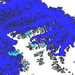
var dataset = ee.FeatureCollection('GLIMS/current');\nvar visParams = {\n palette: ['gray', 'cyan', 'blue'],\n min: 0.0,\n max: 10.0,\n opacity: 0.8,\n};\nvar image = ee.Image().float().paint(dataset, 'area');\nMap.setCenter(-35.618, 66.743, 7);\nMap.addLayer(image, visParams, 'GLIMS/current');\nMap.addLayer(dataset, null, 'for Inspector', false);\n```\n[Open in Code Editor](https://code.earthengine.google.com/?scriptPath=Examples:Datasets/GLIMS/GLIMS_current)\n\n### Visualize as a FeatureView\n\n\nA `FeatureView` is a view-only, accelerated representation of a\n`FeatureCollection`. For more details, visit the\n[`FeatureView` documentation.](/earth-engine/guides/featureview_overview)\n| **Important:** Earth Engine is a platform for petabyte-scale scientific analysis and visualization of geospatial datasets, both for public benefit and for business and government users. Earth Engine is free to use for research, education, and nonprofit use. To get started, please [register for Earth Engine access.](https://console.cloud.google.com/earth-engine)\n\n### Code Editor (JavaScript)\n\n```javascript\nvar fvLayer = ui.Map.FeatureViewLayer('GLIMS/current_FeatureView');\n\nvar visParams = {\n color: {\n property: 'area',\n mode: 'linear',\n palette: ['gray', 'cyan', 'blue'],\n min: 0.0,\n max: 10.0\n },\n opacity: 0.8,\n polygonStrokeOpacity: 0\n};\n\nfvLayer.setVisParams(visParams);\nfvLayer.setName('GLIMS/current');\n\nMap.setCenter(-35.618, 66.743, 7);\nMap.add(fvLayer);\n```\n[Open in Code Editor](https://code.earthengine.google.com/?scriptPath=Examples:Datasets/GLIMS/GLIMS_current_FeatureView) \n[GLIMS Current: Global Land Ice Measurements From Space](/earth-engine/datasets/catalog/GLIMS_current) \nGlobal Land Ice Measurements from Space (GLIMS) is an international initiative with the goal of repeatedly surveying the world's estimated 200,000 glaciers. The project seeks to create a globally comprehensive inventory of land ice, including measurements of glacier area, geometry, surface velocity, and snow line elevation. To perform these analyses, ... \nGLIMS/current, cryosphere,glacier,glims,ice,landcover,nasa,nsidc,snow,table \n1750-01-01T00:00:00Z/2023-06-07T00:00:00Z \n-90 -180 90 180 \nGoogle Earth Engine \nhttps://developers.google.com/earth-engine/datasets\n\n- [https://doi.org/10.7265/N5V98602](https://doi.org/https://www.glims.org)\n- [https://doi.org/10.7265/N5V98602](https://doi.org/https://developers.google.com/earth-engine/datasets/catalog/GLIMS_current)"]]