- 資料集開放期間
- 2000-01-01T01:00:00Z–2019-12-31T16:45:00Z
- 資料集產生者
- 德國柏林洪堡大學地理學系
- 標記
說明
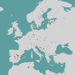
歐洲原始森林資料整合了 48 個不同的原始森林資料集 (大多以實地調查為基礎),包含 33 個國家/地區的 18,411 個獨立地塊 (4,110 萬公頃)。主要包括老齡林和演替後期森林,但也包括自然干擾和自然再生後形成的早期演替階段和幼林,且未經後續管理。
如需更多資訊,包括作者和所屬機構的完整清單,請參閱資料集說明文件。這個資料集是以點為基礎,每個點代表原始森林的大約中心位置。
資料表結構定義
資料表結構定義
| 名稱 | 類型 | 說明 |
|---|---|---|
| BIOGEOGRAP | STRING | 生物地理區域由歐洲環境署定義,包括:阿爾卑斯山、北極、大西洋、黑海、北方、大陸、馬卡羅尼西亞、地中海、潘諾尼亞或草原。 |
| CONTACT_PE | STRING | 聯絡人 |
| DOMINANT_1 | STRING | 上層樹冠層主要樹種的物種 (拉丁文名稱) |
| DOMINANT_2 | STRING | 上層林冠第二個主要樹種的學名 (如有) |
| DOMINANT_T | STRING | 上層樹冠第三個主要樹種的學名 (如有) |
| FOREST_NAM | STRING | 林分名稱 (如適用,否則可為較大區域的名稱) |
| FOREST_SHA | DOUBLE | 假設高自然度等級的主要森林範圍廣大,可能涵蓋暫時或永久未被森林覆蓋的土地,則多邊形實際森林覆蓋率可能較低。 |
| FOREST_TYP | INT | 根據歐洲環境署定義的森林類別,以及歐洲潛在植被類型地圖,判斷主要森林類型。可能的類型包括:
|
| FOREST_T_1 | INT | 根據歐洲環境署定義的森林類別,以及歐洲潛在植被類型地圖,判斷第二種主要森林類型 |
| ID_Dataset | STRING | 資料集 ID |
| LAST_DISTU | STRING | LAST_DISTURBANCE1_TYPE:最後一次干擾事件的類型。可能的值:
|
| LAST_DIS_1 | INT | LAST_DISTURBANCE1_YEAR,發生干擾事件 1 的年份 |
| LAST_DIS_2 | INT | LAST_DISTURBANCE1_INTENSITY:干擾事件 1 的強度。可能的值:
|
| LAST_DIS_3 | STRING | LAST_DISTURBANCE2_TYPE,倒數第二個干擾事件的類型 可能的值:
|
| LAST_DIS_4 | INT | LAST_DISTURBANCE2_YEAR:發生干擾事件 2 的年份 |
| LAST_DIS_5 | INT | LAST_DISTURBANCE2_INTENSITY:干擾事件 2 的強度。可能的值:
|
| LOCATION | STRING | 原始森林殘餘物所在的市、保護區或區域 |
| NATURALNES | INT | 原始森林殘餘的自然度等級:可能的值:
|
| 附註 | STRING | 森林點/多邊形的選用其他備註 |
| OBJECTID | STRING | 物件 ID |
| 保護措施 | INT | 森林林分的法律保護狀態,取自世界保護區資料庫。原始的 IUCN 分類簡化為三類:
如果資料貢獻者提供更準確的最新資訊,我們會優先採用。可能的類型包括:
|
| RELEVANT_L | STRING | 任何描述森林殘餘的相關資訊來源 (包括期刊文章、當地報告和網站) |
| 來源 | STRING | 可直接歸因的森林殘餘資料來源/擁有權歸因 |
| THREATS_1 | INT | 最有可能危及原始森林殘餘的威脅 (如有)。可能的類型包括:
|
| THREATS_2 | INT | 最有可能危及原始森林殘餘的威脅 (如有)。 |
| DATA_AVAIL | STRING | 資料可用性 |
| FOREST_EXT | DOUBLE | 原始森林斑塊的總面積,以公頃為單位。如果森林地塊「不」適用多邊形功能,這個欄位就非常重要。 |
| FOREST_E_1 | INT | 原始森林殘餘地塊範圍的量級。 只有在森林地塊「沒有」多邊形特徵,且無法精確測量森林殘餘總面積時,這個欄位才適用。可能的類型包括:
|
| PUBLICATIO | STRING | 出版 |
使用條款
使用條款
歐洲原始森林資料集是依據 CC BY 4.0 授權提供,允許用於大多數商業、非商業和學術用途。請參閱供應商使用條款。
使用 Earth Engine 探索
程式碼編輯器 (JavaScript)
var dataset = ee.FeatureCollection('HU_BERLIN/EPFD/V2/points');

Map.setCenter(13.64, 50.11, 4);

var styleParams = {
  fillColor: '0F7209',
  color: '000000',
  width: 1.0,
};

dataset = dataset.style(styleParams);

Map.addLayer(dataset, {}, 'European Primary Forest Points');