- 데이터 세트 제공
- 2009-01-01T00:00:00Z–2021-01-01T00:00:00Z
- 데이터 세트 출처
- IGN
- 태그
설명
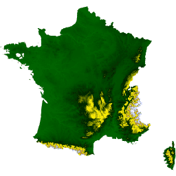
RGE ALTI 데이터 세트는 픽셀 크기가 1m인 프랑스의 디지털 고도 모델 (DEM)을 설명합니다. 항공 라이다로 획득한 측량 또는 항공 이미지의 상관관계로 생성되었습니다.
홍수 발생 가능성이 있는 지역, 해안 지역, 대규모 산림 지역에 LiDAR가 배치되었습니다. 이러한 지역의 DEM 수직 정확도는 0.2m~0.5m입니다. 산악 지역 (알프스, 피레네, 세벤, 코르시카)에서 레이더가 사용되었습니다. 주의: 경사가 심한 지역에서는 평균 수직 정확도가 7m입니다.
이러한 필드의 정확성은 BD TOPO의 도로 및 수로 네트워크, 측지 터미널, 지상에서 계산된 점 등 다양한 소스를 기준으로 확인되었습니다.
나머지 지역에서는 항공 사진 상관관계 기법이 사용됩니다. 상관관계로 처리되는 특정 영역에서는 식물(예: 나무가 있는 지역)이 있어 넓은 범위에 걸쳐 지상 측정이 없습니다. 이러한 격차를 메우기 위해 1987~2001년 고도계 데이터 (BD Alti)가 사용됩니다. 이러한 지역의 DEM 수직 정확도는 0.5m~0.7m입니다.
현재 컬렉션에는 프랑스 대도시를 보여주는 단일 이미지 IGN/RGE_ALTI/1M/2_0/FXX가 포함되어 있습니다.
이 데이터 세트는 Guillaume Attard 및 Julien Bardonnet (AGEOCE)의 지원을 받아 준비되고 수집되었습니다. 준비 과정은 여기에 설명되어 있습니다.
사용자 가이드도 참고하세요.
대역
대역
픽셀 크기: 1미터 (모든 밴드)
| 이름 | 단위 | 최소 | 최대 | 픽셀 크기 | 설명 |
|---|---|---|---|---|---|
MNT |
m | -40* | 4810* | 1미터 | 지형 고도(단위: 미터)입니다. |
SRC |
1미터 | 노드의 고도를 계산하는 데 사용되는 데이터의 기본 소스입니다. 사용자 가이드의 부록 B 26페이지를 참고하세요. |
|||
DST |
m | 0 | 255 | 1미터 | 노드와 고도를 계산하는 데 사용되는 가장 가까운 점 사이의 거리(미터)입니다. |
이용약관
이용약관
인용
IGN (2021년). RGE ALTI 1m [데이터 세트]. IGN 웹사이트에서 2022년 7월 1일에 액세스함
Earth Engine으로 탐색
코드 편집기(JavaScript)
var dataset = ee.Image('IGN/RGE_ALTI/1M/2_0/FXX');
var elevation = dataset.select('MNT');

var elevationVis = {
  min: 0,
  max: 1000,
  palette: ['006600', '002200', 'fff700', 'ab7634', 'c4d0ff', 'ffffff']
};

Map.addLayer(elevation, elevationVis, 'Elevation');
Map.setCenter(3, 47, 5);