- Доступность набора данных
- 2009-01-01T00:00:00Z–2021-01-01T00:00:00Z
- Производитель наборов данных
- IGN
- Теги
Описание
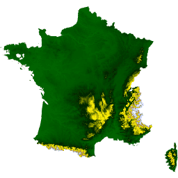
Набор данных RGE ALTI описывает цифровую модель рельефа (ЦМР) Франции с размером пикселя 1 м. Она была создана на основе данных аэрофотосъемки с использованием лидара или путем корреляции аэрофотоснимков.
Лидар использовался в районах, подверженных наводнениям, прибрежных зонах и крупных лесных массивах. Вертикальная точность ЦМР в этих районах составляет от 0,2 до 0,5 м. Радар применялся в горных районах (Альпы, Пиренеи, Севенны, Корсика). Внимание: в районах с крутыми склонами средняя вертикальная точность составляет порядка 7 м.
Точность этих данных была проверена по различным источникам: дорожной и гидрографической сети BD TOPO , геодезическим терминалам и точкам, рассчитанным на местности.
На остальной территории используются методы корреляции аэрофотоснимков. В некоторых зонах, обработанных методом корреляции, наземные измерения отсутствуют на больших участках из-за наличия растительности (например, лесных массивов). Для заполнения этих пробелов используются данные альтиметрии за 1987-2001 годы (BD Alti). Вертикальная точность ЦМР на этих участках составляет от 0,5 до 0,7 м.
В настоящее время коллекция включает в себя единственное изображение IGN/RGE_ALTI/1M/2_0/FXX, на котором изображена материковая Франция.
Данный набор данных был подготовлен и обработан при поддержке Гийома Аттарда и Жюльена Бардонне ( AGEOCE ). Процесс подготовки описан здесь .
См. также: руководство пользователя .
Группы
Группы
Размер пикселя: 1 метр (все диапазоны)
| Имя | Единицы | Мин | Макс | Размер пикселя | Описание |
|---|---|---|---|---|---|
MNT | м | -40* | 4810* | 1 метр | Высота местности в метрах. |
SRC | 1 метр | Основной источник данных, используемых для расчета высоты узла. См. Приложение B, страница 26, руководство пользователя . | |||
DST | м | 0 | 255 | 1 метр | Расстояние в метрах между узлом и ближайшей точкой, используемой для расчета его высоты. |
Условия эксплуатации
Условия эксплуатации
Цитаты
IGN (2021). RGE ALTI 1m [Набор данных]. Доступно 01.07.2022 на веб-сайте IGN.
Исследуйте мир с помощью Earth Engine.
Редактор кода (JavaScript)
var dataset = ee.Image('IGN/RGE_ALTI/1M/2_0/FXX');
var elevation = dataset.select('MNT');

var elevationVis = {
  min: 0,
  max: 1000,
  palette: ['006600', '002200', 'fff700', 'ab7634', 'c4d0ff', 'ffffff']
};

Map.addLayer(elevation, elevationVis, 'Elevation');
Map.setCenter(3, 47, 5);