- ডেটাসেট উপলব্ধতা
- 2001-01-01T00:00:00Z–2017-01-01T00:00:00Z
- ডেটাসেট প্রদানকারী
- আইএসডিএ
- ট্যাগ
বর্ণনা
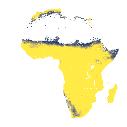
0-200 সেমি গভীরতায় বেডরক থেকে গভীরতা, পূর্বাভাসিত গড় এবং মানক বিচ্যুতি।
সম্ভাব্য ফসলি জমির মুখোশের কারণে যেটি ডেটা তৈরির জন্য ব্যবহৃত হয়েছিল, উন্মুক্ত শিলার অনেক এলাকা (যেখানে গভীরতা 0 সেমি হবে) মুখোশ করা হয়েছে এবং তাই নোডাটা মান হিসাবে উপস্থিত হয়েছে। এই স্তরটির সর্বোচ্চ গভীরতা 200 সেমি, কিন্তু এটি সর্বোচ্চ সম্ভাব্য মাটির গভীরতার প্রতিনিধিত্ব করে না, তাই 200-এর মানকে >= 200 হিসাবে ব্যাখ্যা করা উচিত।
ঘন জঙ্গলের এলাকায় (সাধারণত মধ্য আফ্রিকার উপরে), মডেলের নির্ভুলতা কম এবং তাই ব্যান্ডিং (স্ট্রাইপিং) এর মতো শিল্পকর্ম দেখা যেতে পারে।
ইনোভেটিভ সলিউশন ফর ডিসিশন এগ্রিকালচার লিমিটেড (iSDA) দ্বারা 30 মিটার পিক্সেল আকারে মেশিন লার্নিং এবং রিমোট সেন্সিং ডেটা এবং 100,000 টিরও বেশি বিশ্লেষণ করা মাটির নমুনার একটি প্রশিক্ষণ সেট ব্যবহার করে মাটির সম্পত্তির ভবিষ্যদ্বাণী করা হয়েছিল।
আরও তথ্য FAQ এবং প্রযুক্তিগত তথ্য ডকুমেন্টেশনে পাওয়া যাবে। একটি সমস্যা জমা দিতে বা সহায়তার অনুরোধ করতে, অনুগ্রহ করে iSDAsoil সাইটে যান।
ব্যান্ড
পিক্সেল সাইজ
30 মিটার
ব্যান্ড
| নাম | ইউনিট | মিন | সর্বোচ্চ | পিক্সেল সাইজ | বর্ণনা |
|---|---|---|---|---|---|
mean_0_200 | সেমি | 27 | 200 | মিটার | গভীরতা থেকে বেডরক, পূর্বাভাসিত গড় 0-200 সেমি গভীরতায় |
stdev_0_200 | সেমি | 9 | 254 | মিটার | বেডরক থেকে গভীরতা, 0-20 সেমি গভীরতায় আদর্শ বিচ্যুতি |
ব্যবহারের শর্তাবলী
ব্যবহারের শর্তাবলী
উদ্ধৃতি
Hengl, T., Miller, MAE, Križan, J., et al. আফ্রিকান মাটির বৈশিষ্ট্য এবং পুষ্টি উপাদান 30 মিটার স্থানিক রেজোলিউশনে ম্যাপ করা হয়েছে টু-স্কেল এনসেম্বল মেশিন লার্নিং ব্যবহার করে। Sci Rep 11, 6130 (2021)। doi:10.1038/s41598-021-85639-y
আর্থ ইঞ্জিন দিয়ে অন্বেষণ করুন
কোড এডিটর (জাভাস্ক্রিপ্ট)
var mean_0_200 =
'<RasterSymbolizer>' +
 '<ColorMap type="ramp">' +
  '<ColorMapEntry color="#00204D" label="0-13" opacity="1" quantity="13"/>' +
  '<ColorMapEntry color="#002D6C" label="13-26" opacity="1" quantity="26"/>' +
  '<ColorMapEntry color="#16396D" label="26-39" opacity="1" quantity="39"/>' +
  '<ColorMapEntry color="#36476B" label="39-52" opacity="1" quantity="52"/>' +
  '<ColorMapEntry color="#4B546C" label="52-65" opacity="1" quantity="65"/>' +
  '<ColorMapEntry color="#5C616E" label="65-78" opacity="1" quantity="78"/>' +
  '<ColorMapEntry color="#6C6E72" label="78-91" opacity="1" quantity="91"/>' +
  '<ColorMapEntry color="#7C7B78" label="91-104" opacity="1" quantity="104"/>' +
  '<ColorMapEntry color="#8E8A79" label="104-117" opacity="1" quantity="117"/>' +
  '<ColorMapEntry color="#A09877" label="117-130" opacity="1" quantity="130"/>' +
  '<ColorMapEntry color="#B3A772" label="130-143" opacity="1" quantity="143"/>' +
  '<ColorMapEntry color="#C6B66B" label="143-156" opacity="1" quantity="156"/>' +
  '<ColorMapEntry color="#DBC761" label="156-169" opacity="1" quantity="169"/>' +
  '<ColorMapEntry color="#F0D852" label="169-182" opacity="1" quantity="182"/>' +
  '<ColorMapEntry color="#FFEA46" label="182-200" opacity="1" quantity="195"/>' +
 '</ColorMap>' +
 '<ContrastEnhancement/>' +
'</RasterSymbolizer>';

var stdev_0_200 =
'<RasterSymbolizer>' +
 '<ColorMap type="ramp">' +
  '<ColorMapEntry color="#fde725" label="low" opacity="1" quantity="14"/>' +
  '<ColorMapEntry color="#5dc962" label=" " opacity="1" quantity="18"/>' +
  '<ColorMapEntry color="#20908d" label=" " opacity="1" quantity="21"/>' +
  '<ColorMapEntry color="#3a528b" label=" " opacity="1" quantity="22"/>' +
  '<ColorMapEntry color="#440154" label="high" opacity="1" quantity="25"/>' +
 '</ColorMap>' +
 '<ContrastEnhancement/>' +
'</RasterSymbolizer>';

var raw = ee.Image("ISDASOIL/Africa/v1/bedrock_depth");
Map.addLayer(
    raw.select(0).sldStyle(mean_0_200), {},
    "Bedrock depth, mean visualization, 0-200 cm");
Map.addLayer(
    raw.select(1).sldStyle(stdev_0_200), {},
    "Bedrock depth, stdev visualization, 0-200 cm");

var visualization = {min: 27, max: 200};

Map.setCenter(25, -3, 2);

Map.addLayer(raw.select(0), visualization, "Bedrock depth, mean, 0-200 cm");