- 資料集可用性
- 2001-01-01T00:00:00Z–2017-01-01T00:00:00Z
- 資料集來源
- iSDA
- 標記
說明
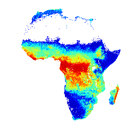
土壤深度 0 到 20 公分和 20 到 50 公分的 pH 值、預測平均值和標準差。
像素值必須使用 x/10 進行反向轉換。
在叢林密布的區域 (通常位於中非),模型準確度較低,因此可能會出現帶狀 (條紋) 等構件。
土壤性質預測是由 Innovative Solutions for Decision Agriculture Ltd. (iSDA) 進行,採用機器學習技術搭配遙測資料,以及超過 10 萬個分析過的土壤樣本訓練集,以 30 公尺的像素大小進行預測。
詳情請參閱常見問題和技術資訊說明文件。如要提交問題或要求支援,請前往iSDAsoil 網站。
頻帶
像素大小
30 公尺
頻帶
| 名稱 | 最小值 | 最大值 | 像素大小 | 說明 |
|---|---|---|---|---|
mean_0_20 |
35 | 103 | 公尺 | pH 值,預測平均值 (深度 0 到 20 公分) |
mean_20_50 |
35 | 102 | 公尺 | pH 值,預測平均值 (20 至 50 公分深度) |
stdev_0_20 |
0 | 18 | 公尺 | pH 值,0 到 20 公分深度的標準差 |
stdev_20_50 |
0 | 18 | 公尺 | pH 值,20 至 50 公分深度的標準差 |
使用條款
使用條款
引用內容
引用內容:
Hengl, T.、Miller, M.A.E.、Križan, J. 等人。African soil properties and nutrients mapped at 30 m spatial resolution using two-scale ensemble machine learning.Sci Rep 11, 6130 (2021). doi:10.1038/s41598-021-85639-y
使用 Earth Engine 探索
程式碼編輯器 (JavaScript)
var mean_0_20 =
'<RasterSymbolizer>' +
 '<ColorMap type="ramp">' +
  '<ColorMapEntry color="#CC0000" label="3.5-4.6" opacity="1" quantity="46"/>' +
  '<ColorMapEntry color="#FF0000" label="4.6-4.9" opacity="1" quantity="49"/>' +
  '<ColorMapEntry color="#FF5500" label="4.9-5.2" opacity="1" quantity="52"/>' +
  '<ColorMapEntry color="#FFAA00" label="5.2-5.4" opacity="1" quantity="54"/>' +
  '<ColorMapEntry color="#FFFF00" label="5.4-5.5" opacity="1" quantity="55"/>' +
  '<ColorMapEntry color="#D4FF2B" label="5.5-5.6" opacity="1" quantity="56"/>' +
  '<ColorMapEntry color="#AAFF55" label="5.6-5.7" opacity="1" quantity="57"/>' +
  '<ColorMapEntry color="#80FF80" label="5.7-5.9" opacity="1" quantity="59"/>' +
  '<ColorMapEntry color="#55FFAA" label="5.9-6" opacity="1" quantity="60"/>' +
  '<ColorMapEntry color="#2BFFD5" label="6-6.2" opacity="1" quantity="62"/>' +
  '<ColorMapEntry color="#00FFFF" label="6.2-6.3" opacity="1" quantity="63"/>' +
  '<ColorMapEntry color="#00AAFF" label="6.3-6.6" opacity="1" quantity="66"/>' +
  '<ColorMapEntry color="#0055FF" label="6.6-6.8" opacity="1" quantity="68"/>' +
  '<ColorMapEntry color="#0000FF" label="6.8-7.1" opacity="1" quantity="71"/>' +
  '<ColorMapEntry color="#0000CC" label="7.1-10.5" opacity="1" quantity="76"/>' +
 '</ColorMap>' +
 '<ContrastEnhancement/>' +
'</RasterSymbolizer>';

var mean_20_50 =
'<RasterSymbolizer>' +
 '<ColorMap type="ramp">' +
  '<ColorMapEntry color="#CC0000" label="3.5-4.6" opacity="1" quantity="46"/>' +
  '<ColorMapEntry color="#FF0000" label="4.6-4.9" opacity="1" quantity="49"/>' +
  '<ColorMapEntry color="#FF5500" label="4.9-5.2" opacity="1" quantity="52"/>' +
  '<ColorMapEntry color="#FFAA00" label="5.2-5.4" opacity="1" quantity="54"/>' +
  '<ColorMapEntry color="#FFFF00" label="5.4-5.5" opacity="1" quantity="55"/>' +
  '<ColorMapEntry color="#D4FF2B" label="5.5-5.6" opacity="1" quantity="56"/>' +
  '<ColorMapEntry color="#AAFF55" label="5.6-5.7" opacity="1" quantity="57"/>' +
  '<ColorMapEntry color="#80FF80" label="5.7-5.9" opacity="1" quantity="59"/>' +
  '<ColorMapEntry color="#55FFAA" label="5.9-6" opacity="1" quantity="60"/>' +
  '<ColorMapEntry color="#2BFFD5" label="6-6.2" opacity="1" quantity="62"/>' +
  '<ColorMapEntry color="#00FFFF" label="6.2-6.3" opacity="1" quantity="63"/>' +
  '<ColorMapEntry color="#00AAFF" label="6.3-6.6" opacity="1" quantity="66"/>' +
  '<ColorMapEntry color="#0055FF" label="6.6-6.8" opacity="1" quantity="68"/>' +
  '<ColorMapEntry color="#0000FF" label="6.8-7.1" opacity="1" quantity="71"/>' +
  '<ColorMapEntry color="#0000CC" label="7.1-10.5" opacity="1" quantity="76"/>' +
 '</ColorMap>' +
 '<ContrastEnhancement/>' +
'</RasterSymbolizer>';

var stdev_0_20 =
'<RasterSymbolizer>' +
 '<ColorMap type="ramp">' +
  '<ColorMapEntry color="#fde725" label="low" opacity="1" quantity="1"/>' +
  '<ColorMapEntry color="#5dc962" label=" " opacity="1" quantity="2"/>' +
  '<ColorMapEntry color="#20908d" label=" " opacity="1" quantity="3"/>' +
  '<ColorMapEntry color="#3a528b" label=" " opacity="1" quantity="4"/>' +
  '<ColorMapEntry color="#440154" label="high" opacity="1" quantity="5"/>' +
 '</ColorMap>' +
 '<ContrastEnhancement/>' +
'</RasterSymbolizer>';

var stdev_20_50 =
'<RasterSymbolizer>' +
 '<ColorMap type="ramp">' +
  '<ColorMapEntry color="#fde725" label="low" opacity="1" quantity="1"/>' +
  '<ColorMapEntry color="#5dc962" label=" " opacity="1" quantity="2"/>' +
  '<ColorMapEntry color="#20908d" label=" " opacity="1" quantity="3"/>' +
  '<ColorMapEntry color="#3a528b" label=" " opacity="1" quantity="4"/>' +
  '<ColorMapEntry color="#440154" label="high" opacity="1" quantity="5"/>' +
 '</ColorMap>' +
 '<ContrastEnhancement/>' +
'</RasterSymbolizer>';
var raw = ee.Image("ISDASOIL/Africa/v1/ph");
Map.addLayer(
    raw.select(0).sldStyle(mean_0_20), {},
    "ph, mean visualization, 0-20 cm");
Map.addLayer(
    raw.select(1).sldStyle(mean_20_50), {},
    "ph, mean visualization, 20-50 cm");
Map.addLayer(
    raw.select(2).sldStyle(stdev_0_20), {},
    "ph, stdev visualization, 0-20 cm");
Map.addLayer(
    raw.select(3).sldStyle(stdev_20_50), {},
    "ph, stdev visualization, 20-50 cm");

var converted = raw.divide(10);

var visualization = {min: 4, max: 8};

Map.setCenter(25, -3, 2);

Map.addLayer(converted.select(0), visualization, "ph, mean, 0-20 cm");