- Disponibilidad del conjunto de datos
- 2001-01-01T00:00:00Z–2017-01-01T00:00:00Z
- Proveedor de conjuntos de datos
- iSDA
- Etiquetas
Descripción
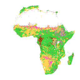
Clase de textura del USDA en profundidades de suelo de 0 a 20 cm y de 20 a 50 cm. En las áreas de selva densa (generalmente en África central), la precisión del modelo es baja y, por lo tanto, se pueden observar artefactos como bandas (rayas).
Innovative Solutions for Decision Agriculture Ltd. (iSDA) realizó las predicciones de las propiedades del suelo con un tamaño de píxel de 30 m utilizando el aprendizaje automático junto con datos de detección remota y un conjunto de entrenamiento de más de 100,000 muestras de suelo analizadas.
Puedes encontrar más información en las preguntas frecuentes y la documentación de información técnica. Para enviar un problema o solicitar asistencia, visita el sitio de iSDAsoil.
Bandas
Tamaño de píxel
30 metros
Bandas
| Nombre | Tamaño de los píxeles | Descripción |
|---|---|---|
texture_0_20 |
metros | Clase de textura del USDA a una profundidad de 0 a 20 cm |
texture_20_50 |
metros | Clase de textura del USDA a una profundidad de 20 a 50 cm |
Tabla de clases de texture_0_20
| Valor | Color | Descripción |
|---|---|---|
| 1 | #d5c36b | Arcilla |
| 2 | #b96947 | Arcilla limosa |
| 3 | #9d3706 | Arcilla arenosa |
| 4 | #ae868f | Franco arcilloso |
| 5 | #f86714 | Franco arcilloso limoso |
| 6 | #46d143 | Franco arcilloso arenoso |
| 7 | #368f20 | Loam |
| 8 | #3e5a14 | Franco limoso |
| 9 | #ffd557 | Franco arenoso |
| 10 | #fff72e | Limo |
| 11 | #ff5a9d | Arena arcillosa |
| 12 | #ff005b | Arena |
texture_20_50 Class Table
| Valor | Color | Descripción |
|---|---|---|
| 1 | #d5c36b | Arcilla |
| 2 | #b96947 | Arcilla limosa |
| 3 | #9d3706 | Arcilla arenosa |
| 4 | #ae868f | Franco arcilloso |
| 5 | #f86714 | Franco arcilloso limoso |
| 6 | #46d143 | Franco arcilloso arenoso |
| 7 | #368f20 | Loam |
| 8 | #3e5a14 | Franco limoso |
| 9 | #ffd557 | Franco arenoso |
| 10 | #fff72e | Limo |
| 11 | #ff5a9d | Arena arcillosa |
| 12 | #ff005b | Arena |
Condiciones de Uso
Condiciones de Uso
Citas
Hengl, T., Miller, M.A.E., Križan, J., et al. African soil properties and nutrients mapped at 30 m spatial resolution using two-scale ensemble machine learning. Sci Rep 11, 6130 (2021). doi:10.1038/s41598-021-85639-y
Explora con Earth Engine
Editor de código (JavaScript)
var raw = ee.Image("ISDASOIL/Africa/v1/texture_class");
Map.addLayer(
    raw.select(0), {}, "Texture class, 0-20 cm");
Map.addLayer(
    raw.select(1), {}, "Texture class, 20-50 cm");

Map.setCenter(25, -3, 2);