- Disponibilité des ensembles de données
- 1905-04-01T00:00:00Z–2016-07-05T00:00:00Z
- Fournisseur de l'ensemble de données
- ISRIC – World Soil Information
- Tags
Description
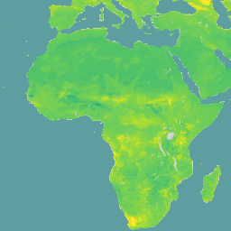
Teneur en eau volumétrique à 10 kPa, 33 kPa et 1 500 kPa de succion en 10^-3 cm^3/cm^3 (0, 1 v% ou 1 mm/m) à six profondeurs standards (0-5 cm, 5-15 cm, 15-30 cm, 30-60 cm, 60-100 cm, 100-200 cm). Les prédictions ont été obtenues à l'aide d'une approche de cartographie numérique des sols basée sur la forêt aléatoire quantile, en s'appuyant sur une compilation mondiale de données de profil de sol et de couches environnementales. Cet ensemble de données inclut des prédictions pour trois niveaux d'aspiration différents, ce qui permet d'obtenir des informations sur la disponibilité de l'eau dans le sol.
L'ensemble de données est organisé en trois ressources principales : /wv0010, /wv0033 et /wv1500. Chacun de ces composants contient des bandes représentant les propriétés du sol à différentes profondeurs et différents quantiles. Les noms de bandes suivent le modèle val_<depth>_<quantile>, où depth représente une plage de profondeur du sol (par exemple, 0-5 cm, 5-15 cm, 15-30 cm, 30-60 cm, 60-100 cm, 100-200 cm) et quantile représente une mesure statistique (par exemple, moyenne, Q0.05, Q0.5, Q0.95).
La bande d'incertitude n'est pas encore incluse. Il est possible de calculer l'incertitude à partir du ratio entre la plage interquartile (largeur de l'intervalle de prédiction à 90 %) et la médiane : (Q0.95-Q0.05)/Q0.50.
Documentation :
Bracelets
Taille des pixels
250 mètres
Bandes de fréquences
| Nom | Unités | Taille des pixels | Description |
|---|---|---|---|
val_0_5cm_mean |
cm^3/cm^3 | mètres | Teneur moyenne en eau volumétrique (profondeur de 0 à 5 cm) |
val_0_5cm_Q0_05 |
cm^3/cm^3 | mètres | Q0.05 : teneur en eau volumétrique (profondeur de 0 à 5 cm) |
val_0_5cm_Q0_5 |
cm^3/cm^3 | mètres | Q0.5 : teneur en eau volumétrique (profondeur de 0 à 5 cm) |
val_0_5cm_Q0_95 |
cm^3/cm^3 | mètres | Q0.95 : teneur en eau volumétrique (profondeur de 0 à 5 cm) |
val_5_15cm_mean |
cm^3/cm^3 | mètres | Teneur moyenne en eau volumétrique (profondeur de 5 à 15 cm) |
val_5_15cm_Q0_05 |
cm^3/cm^3 | mètres | Q0.05 : teneur en eau volumétrique (profondeur de 5 à 15 cm) |
val_5_15cm_Q0_5 |
cm^3/cm^3 | mètres | Q0.5 : teneur en eau volumétrique (profondeur de 5 à 15 cm) |
val_5_15cm_Q0_95 |
cm^3/cm^3 | mètres | Q0.95 : teneur en eau volumétrique (profondeur de 5 à 15 cm) |
val_15_30cm_mean |
cm^3/cm^3 | mètres | Teneur en eau volumétrique moyenne (profondeur de 15 à 30 cm) |
val_15_30cm_Q0_05 |
cm^3/cm^3 | mètres | Q0.05 : teneur en eau volumétrique (profondeur de 15 à 30 cm) |
val_15_30cm_Q0_5 |
cm^3/cm^3 | mètres | Q0.5 : teneur en eau volumétrique (profondeur de 15 à 30 cm) |
val_15_30cm_Q0_95 |
cm^3/cm^3 | mètres | Q0.95 : teneur en eau volumétrique (profondeur de 15 à 30 cm) |
val_30_60cm_mean |
cm^3/cm^3 | mètres | Teneur moyenne en eau volumétrique (profondeur de 30 à 60 cm) |
val_30_60cm_Q0_05 |
cm^3/cm^3 | mètres | Q0.05 Volumetric Water Content (30-60cm depth) |
val_30_60cm_Q0_5 |
cm^3/cm^3 | mètres | Q0.5 : teneur en eau volumétrique (profondeur de 30 à 60 cm) |
val_30_60cm_Q0_95 |
cm^3/cm^3 | mètres | Q0.95 : teneur en eau volumétrique (profondeur de 30 à 60 cm) |
val_60_100cm_mean |
cm^3/cm^3 | mètres | Teneur moyenne en eau volumétrique (profondeur de 60 à 100 cm) |
val_60_100cm_Q0_05 |
cm^3/cm^3 | mètres | Q0.05 : teneur volumétrique en eau (profondeur de 60 à 100 cm) |
val_60_100cm_Q0_5 |
cm^3/cm^3 | mètres | Q0.5 : teneur en eau volumétrique (profondeur de 60 à 100 cm) |
val_60_100cm_Q0_95 |
cm^3/cm^3 | mètres | Q0.95 : teneur volumétrique en eau (profondeur de 60 à 100 cm) |
val_100_200cm_mean |
cm^3/cm^3 | mètres | Teneur moyenne en eau volumétrique (profondeur de 100 à 200 cm) |
val_100_200cm_Q0_05 |
cm^3/cm^3 | mètres | Q0.05 : teneur en eau volumétrique (profondeur de 100 à 200 cm) |
val_100_200cm_Q0_5 |
cm^3/cm^3 | mètres | Q0.5 : teneur en eau volumétrique (profondeur de 100 à 200 cm) |
val_100_200cm_Q0_95 |
cm^3/cm^3 | mètres | Q0.95 : teneur en eau volumétrique (profondeur de 100 à 200 cm) |
Conditions d'utilisation
Conditions d'utilisation
Citations
Cartographie mondiale de la rétention volumétrique d'eau à 100, 330 et 15 000 cm de succion à l'aide de la base de données WoSIS Turek M.E., Poggio L., Batjes N.H., Armindo R.A., de Jong van Lier Q., de Sousa L., Heuvelink G.B.M. (2023) International Soil and Water Conservation Research, 11 (2), pp. 225-239.
DOI
Explorer avec Earth Engine
Éditeur de code (JavaScript)
var dataset = ee.Image('ISRIC/SoilGrids250m/v2_0/wv0010').select('val_0_5cm_Q0_95');

Map.setCenter(-105.25, 52.5, 3);

Map.addLayer(
    dataset, {
      min: -0.061,
      max: 0.636,
      palette: [
        '#440154', '#482878', '#3E4A89', '#31688E', '#26828E', '#1F9E89',
        '#35B779', '#6DCD59', '#B4DE2C', '#FDE725'
      ]
    },
    'SoilGrids250m 10kPa Q0.95 0-5cm');