- Disponibilità set di dati
- 2006-01-24T00:00:00Z–2011-05-12T00:00:00Z
- Produttore del set di dati
- JAXA Earth Observation Research Center
- Tag
Descrizione
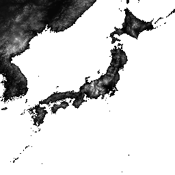
ALOS World 3D - 30 m (AW3D30) è un set di dati del modello digitale della superficie (DSM) globale con una risoluzione orizzontale di circa 30 metri (mesh di 1 secondo d'arco). Il set di dati si basa sul set di dati DSM (versione mesh a 5 metri) dei dati topografici 3D del mondo. Per saperne di più, consulta la documentazione del set di dati.
Questo set di dati importato combina i dati delle versioni 3.1, 4.0 e 4.1.
Versione 4.1 (aprile 2024): questo aggiornamento principale ha rilasciato 19.051 tessere che coprono le regioni globali (esclusi Antartide e Giappone). Incorpora nuovi dati supplementari per il riempimento dei vuoti e corregge le anomalie parziali riscontrate nelle versioni 3.1 e 3.2, oltre a riempire i vuoti. Per aggiornamenti di riquadri specifici nella versione 4.1, utilizza il filtro v4.1 sui riquadri della mappa o consulta la descrizione del formato più recente.
Versione 4.0 (aprile 2023): questo aggiornamento ha rilasciato 1886 tessere, migliorando le regioni a bassa e media latitudine e le aree a sud di 60 gradi di latitudine.
Le modifiche principali includono: 1. Nuovi dati supplementari per il riempimento del vuoto. 2. Correzione di anomalie parziali e riempimento di spazi vuoti (2 tessere). 3. Linee costiere aggiornate per le regioni a sud di 60 gradi di latitudine (44 tessere). 4. Maschera dell'acqua del Mar Caspio disattivata e integrata con dati di elevazione (54 tessere). 5. Sono state estratte e corrette nuove aree di anomalia parziale in Sud America (1786 tessere). 6. Per informazioni dettagliate sui riquadri per la versione 4.0, utilizza il filtro v4.0 sui riquadri della mappa o consulta la descrizione del formato.
La versione 3.2, rilasciata a gennaio 2021, è una versione migliorata creata riconsiderando il formato nell'area ad alta latitudine, i dati ausiliari e il metodo di elaborazione. Nelle aree ad alta latitudine è stato adottato uno spaziatura dei pixel diversa per ogni zona di latitudine. I dati della costa, che fanno parte dei set di dati ausiliari, sono stati modificati e sono stati utilizzati nuovi dati supplementari. Inoltre, come dati di origine per il Giappone, è stata utilizzata anche la versione 3 di AW3D. Inoltre, è stato migliorato il metodo di rilevamento dei valori anomali nel processo.
L'elevazione AW3D DSM viene calcolata mediante un processo di corrispondenza delle immagini che utilizza una coppia stereo di immagini ottiche. Nuvole, neve e ghiaccio vengono identificati automaticamente durante l'elaborazione e vengono applicate le informazioni sulla maschera. Tuttavia, a volte i punti non corrispondenti rimangono soprattutto intorno (o ai bordi) di nuvole, neve e aree di ghiaccio, il che causa alcuni errori di altezza nel DSM finale.
Bande
Bande
Dimensioni pixel: 30 metri (tutte le bande)
| Nome | Min | Max | Dimensioni pixel | Descrizione | |||||||||||||||||||||||||||||||||||||||||||||||||||||||||||||||||||||||||||||||||||||||||||||||
|---|---|---|---|---|---|---|---|---|---|---|---|---|---|---|---|---|---|---|---|---|---|---|---|---|---|---|---|---|---|---|---|---|---|---|---|---|---|---|---|---|---|---|---|---|---|---|---|---|---|---|---|---|---|---|---|---|---|---|---|---|---|---|---|---|---|---|---|---|---|---|---|---|---|---|---|---|---|---|---|---|---|---|---|---|---|---|---|---|---|---|---|---|---|---|---|---|---|---|---|
DSM |
-433* | 8768* | 30 metri | Altezza sopra il livello del mare. 16 bit con segno. Altezza (in metri) convertita dall'altezza ellissoidale basata su ITRF97 e GRS80, utilizzando il modello di geoide EGM96†1. |
|||||||||||||||||||||||||||||||||||||||||||||||||||||||||||||||||||||||||||||||||||||||||||||||
STK |
1* | 54* | 30 metri | Numero di stacking dell'unità di scena DSM utilizzata per la produzione del DSM. La banda viene derivata dal ricampionamento del numero di stacking per il DSM con risoluzione di 5 m a una risoluzione di 30 m. |
|||||||||||||||||||||||||||||||||||||||||||||||||||||||||||||||||||||||||||||||||||||||||||||||
MSK |
30 metri | Maschera a 8 bit per la banda. |
|||||||||||||||||||||||||||||||||||||||||||||||||||||||||||||||||||||||||||||||||||||||||||||||||
Termini e condizioni d'uso
Termini e condizioni d'uso
Questo set di dati è disponibile per l'utilizzo senza costi alle condizioni specificate nei Termini di utilizzo del modello digitale di superficie globale ALOS.
Citazioni
- T. Tadono, H. Ishida, F. Oda, S. Naito, K. Minakawa, H. Iwamoto
- Precise Global DEM Generation By ALOS PRISM, ISPRS Annals of the Photogrammetry, Remote Sensing and Spatial Information Sciences, Vol.II-4, pp.71-76, 2014. File PDF
J. Takaku, T. Tadono, K. Tsutsui : Generation of High Resolution Global DSM from ALOS PRISM, The International Archives of the Photogrammetry, Remote Sensing and Spatial Information Sciences, Vol. XL-4, pp.243-248, ISPRS, 2014. File PDF
J. Takaku, T. Tadono, K. Tsutsui, M. Ichikawa : Validation of 'AW3D' Global DSM Generated from ALOS PRISM, ISPRS Annals of the Photogrammetry, Remote Sensing and Spatial Information Sciences, Vol.III-4, pp.25-31, 2016. File PDF
T. Tadono, H. Nagai, H. Ishida, F. Oda, S. Naito, K. Minakawa, H. Iwamoto : Initial Validation of the 30 m-mesh Global Digital Surface Model Generated by ALOS PRISM, The International Archives of the Photogrammetry, Remote Sensing and Spatial Information Sciences, ISPRS, Vol. XLI-B4, pp.157-162, 2016. File PDF
J. Takaku, T. Tadono, M. Doutsu, F. Ohgushi e H. Kai, : "Updates of 'AW3D30' ALOS Global Digital Surface Model in Antarctica with Other Open Access Datasets", Int. Arch. Photogramm. Remote Sens. Spatial Inf. Sci., XLIII-B4-2021, 401-408, 2021. File PDF
Esplora con Earth Engine
Editor di codice (JavaScript)
var dataset = ee.ImageCollection('JAXA/ALOS/AW3D30/V4_1');
var elevation = dataset.select('DSM');
var elevationVis = {
  min: 0,
  max: 5000,
  palette: ['0000ff', '00ffff', 'ffff00', 'ff0000', 'ffffff']
};
Map.setCenter(138.73, 35.36, 11);
Map.addLayer(elevation, elevationVis, 'Elevation');

// Reproject an image mosaic using a projection from one of the image tiles,
// rather than using the default projection returned by .mosaic().
var proj = elevation.first().select(0).projection();
var slopeReprojected = ee.Terrain.slope(elevation.mosaic()
                             .setDefaultProjection(proj));
Map.addLayer(slopeReprojected, {min: 0, max: 45}, 'Slope');