- Disponibilidade de conjuntos de dados
- 2007-01-01T00:00:00Z–2018-01-01T00:00:00Z
- Provedor de conjunto de dados
- JAXA EORC
- Tags
Descrição
Uma versão mais recente desse conjunto de dados com quatro classes para 2017 a 2020 pode ser encontrada em JAXA/ALOS/PALSAR/YEARLY/FNF4
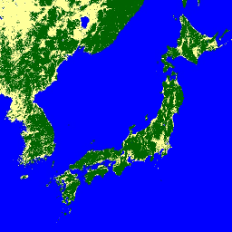
O mapa global de floresta/não floresta (FNF) é gerado classificando a imagem SAR (coeficiente de retroespalhamento) no mosaico global de 25 m de resolução PALSAR-2/PALSAR SAR para que pixels de retroespalhamento forte e baixo sejam atribuídos como "floresta" e "não floresta", respectivamente. Aqui, "floresta" é definida como a floresta natural com área maior que 0,5 ha e cobertura florestal acima de 10%. Essa definição é a mesma da Organização das Nações Unidas para Alimentação e Agricultura (FAO). Como o radar de retroespalhamento da floresta depende da região (zona climática), a classificação de floresta/não floresta é feita usando um limite de retroespalhamento dependente da região. A acurácia da classificação é verificada usando fotos in situ e imagens de satélite ópticas de alta resolução. Informações detalhadas estão disponíveis na descrição do conjunto de dados do provedor.
Atenção:
- Os valores de retroespalhamento podem variar significativamente de um caminho para outro em áreas florestais de alta latitude. Isso ocorre devido à mudança na intensidade de retroespalhamento causada pelo congelamento das árvores no inverno. Isso pode afetar a classificação de floresta/não floresta.
Bandas
Tamanho do pixel
25 metros
Bandas
| Nome | Mín. | Máx. | Tamanho do pixel | Descrição |
|---|---|---|---|---|
fnf |
1 | 3 | metros | Classificação de cobertura de terra florestal/não florestal |
Tabela de classes fnf
| Valor | Cor | Descrição |
|---|---|---|
| 1 | #006400 | Floresta |
| 2 | #feff99 | Não floresta |
| 3 | #0000ff | Água |
Termos de Uso
Termos de Uso
A JAXA mantém a propriedade do conjunto de dados e não garante nenhum problema causado ou possivelmente causado pelo uso dos conjuntos de dados. Qualquer pessoa que queira publicar resultados usando os conjuntos de dados precisa reconhecer claramente a propriedade dos dados na publicação.
Citações
Masanobu Shimada, Takuya Itoh, Takeshi Motooka, Manabu Watanabe, Shiraishi Tomohiro, Rajesh Thapa e Richard Lucas, "New Global Forest/Non-forest Maps from ALOS PALSAR Data (2007-2010)", Remote Sensing of Environment, 155, pp. 13-31, dezembro de 2014. doi:10.1016/j.rse.2014.04.014.
Explorar com o Earth Engine
Editor de código (JavaScript)
var dataset = ee.ImageCollection('JAXA/ALOS/PALSAR/YEARLY/FNF')
                  .filterDate('2017-01-01', '2017-12-31');
var forestNonForest = dataset.select('fnf');
var forestNonForestVis = {
  min: 1,
  max: 3,
  palette: ['006400', 'feff99', '0000ff'],
};
Map.setCenter(136.85, 37.37, 4);
Map.addLayer(forestNonForest, forestNonForestVis, 'Forest/Non-Forest');