- Disponibilidade de conjuntos de dados
- 2021-11-29T00:00:00Z–2025-11-28T00:00:00Z
- Provedor de conjunto de dados
- Missão Global de Observação de Mudanças (GCOM)
- Cadência
- 1 dia
- Tags
Descrição
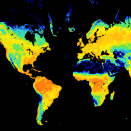
Esse produto é a soma da área foliar verde unilateral por unidade de área de solo.
Esse é um conjunto de dados em andamento com uma latência de três a quatro dias.
O GCOM-C realiza observação global e coleta de dados de longo prazo para elucidar o mecanismo por trás das flutuações no orçamento de radiação e no ciclo de carbono necessário para fazer projeções precisas sobre o aumento futuro da temperatura. Ao mesmo tempo, a cooperação com instituições de pesquisa que têm um modelo numérico climático contribui para a redução de erros na previsão de aumento da temperatura derivada do modelo numérico climático e para a melhoria da precisão da previsão de várias mudanças ambientais. O SGLI montado no GCOM-C é o sensor de sucessão do Global Imager (GLI) montado no ADEOS-II (MIDORI II) e é o radiômetro de imagem que mede a radiação da região do ultravioleta próximo à região do infravermelho térmico (380 nm-12 um) em 19 canais. A observação global de uma vez a cada dois dias é possível em latitude média perto do Japão pela largura de observação no solo de mais de 1.000 km. Além disso, o SGLI tem alta resolução em relação ao sensor global semelhante e tem uma função de observação polarizada e uma função de observação de vários ângulos.
Bandas
Tamanho do pixel
4638,3 metros
Bandas
| Nome | Mín. | Máx. | Tamanho do pixel | Descrição | |||||||||||||||||||||||||||||||||||||||||||||||||||||||||||||||||||||||||||||||||||||||||||||||
|---|---|---|---|---|---|---|---|---|---|---|---|---|---|---|---|---|---|---|---|---|---|---|---|---|---|---|---|---|---|---|---|---|---|---|---|---|---|---|---|---|---|---|---|---|---|---|---|---|---|---|---|---|---|---|---|---|---|---|---|---|---|---|---|---|---|---|---|---|---|---|---|---|---|---|---|---|---|---|---|---|---|---|---|---|---|---|---|---|---|---|---|---|---|---|---|---|---|---|---|
LAI_AVE |
0* | 65531* | metros | A soma da área foliar verde unilateral por unidade de área de solo. |
|||||||||||||||||||||||||||||||||||||||||||||||||||||||||||||||||||||||||||||||||||||||||||||||
LAI_QA_flag |
metros | Controle de qualidade da LAI |
|||||||||||||||||||||||||||||||||||||||||||||||||||||||||||||||||||||||||||||||||||||||||||||||||
Propriedades da imagem
Propriedades de imagens
| Nome | Tipo | Descrição |
|---|---|---|
| ALGORITHM_VERSION | STRING | Versão do algoritmo |
| GRID_INTERVAL | STRING | Resolução espacial |
| GRID_INTERVAL_UNIT | STRING | Unidade de GRID_INTERVAL |
| IMAGE_END_TIME | STRING | Horário de término da aquisição de imagens |
| IMAGE_START_TIME | STRING | Horário de início da aquisição de imagem |
| PROCESSING_RESULT | STRING | Bom, Regular, Ruim, Não aceitável |
| PROCESSING_UT | STRING | Tempo de processamento |
| PRODUCT_FILENAME | STRING | Nome do arquivo de origem |
| PRODUCT_VERSION | STRING | Versão do produto |
| SATELLITE_DIRECTION | STRING | Direção da órbita do satélite
|
| LAI_AVE_OFFSET | STRING | Deslocamento |
| LAI_AVE_SLOPE | STRING | Inclinação |
Termos de Uso
Termos de Uso
Esse conjunto de dados pode ser usado sem restrições, inclusive para uso comercial. Qualquer pessoa que queira publicar resultados analisados ou produtos de dados de valor agregado precisa dar crédito adequado aos dados originais do G-Portal, por exemplo, "Dados de RP da Agência Japonesa de Exploração Aeroespacial". Para produtos de dados de valor agregado, indique o crédito dos dados originais do G-Portal, por exemplo, "Os dados originais para este produto de dados de valor agregado foram fornecidos pela Agência Japonesa de Exploração Aeroespacial."
Consulte os Termos de Serviço do G-Portal (artigo 7) para mais informações.
Citações
Kobayashi, T., Ono, Y., Kobayashi, H., Yang, W. (junho. 2020). GCOM-C/SGLI Índice de área foliar (LAI)/ fração de radiação fotossinteticamente ativa absorvida (fAPAR) Documento de base teórica do algoritmo do produto (versão 2). Disponível em https://suzaku.eorc.jaxa.jp/GCOM_C/data/ATBD/ver2/V2ATBD_T2B_LAI_Kobayashi_r1.pdf
Descobrir com o Earth Engine
Editor de código (JavaScript)
var dataset = ee.ImageCollection('JAXA/GCOM-C/L3/LAND/LAI/V3')
                .filterDate('2021-12-01', '2022-01-01')
                // filter to daytime data only
                .filter(ee.Filter.eq('SATELLITE_DIRECTION', 'D'));

// Multiply with slope coefficient
var dataset = dataset.mean().multiply(0.001);

var visualization = {
  bands: ['LAI_AVE'],
  min: -7,
  max: 7,
  palette: [
    '040274','040281','0502a3','0502b8','0502ce','0502e6',
    '0602ff','235cb1','307ef3','269db1','30c8e2','32d3ef',
    '3be285','3ff38f','86e26f','3ae237','b5e22e','d6e21f',
    'fff705','ffd611','ffb613','ff8b13','ff6e08','ff500d',
    'ff0000','de0101','c21301','a71001','911003',
  ]
};

Map.setCenter(128.45, 33.33, 5);

Map.addLayer(dataset, visualization, 'Leaf Area Index');