GCOM-C는 향후 온도 상승에 관한 정확한 예측을 위해 필요한 복사 에너지 수지와 탄소 순환의 변동 뒤에 있는 메커니즘을 설명하기 위해 장기적이고 지속적인 전 세계 관측 및 데이터 수집을 수행합니다. 동시에 기후 수치 모델을 보유한 연구 기관과 협력하여 기후 수치 모델에서 파생된 온도 상승 예측의 오류를 줄이고 다양한 환경 변화 예측의 정확도를 개선하는 데 기여합니다. GCOM-C에 탑재된 SGLI는 ADEOS-II (MIDORI II)에 탑재된 Global Imager (GLI)의 후속 센서이며, 근자외선에서 열적외선 영역 (380nm~12μm)의 방사선을 19개 채널로 측정하는 이미징 방사계입니다. 지상에서의 관측 폭이 1,000km 이상인 경우 일본 근처 중위도에서 약 2일에 한 번씩 전 세계 관측이 가능합니다. 또한 SGLI는 유사한 전 세계 센서보다 해상도가 높고 편광 관측 기능과 다각도 관측 기능이 있습니다.
대역
픽셀 크기 4638.3m
대역
이름
단위
최소
최대
픽셀 크기
설명
CHLA_AVE
mg/m^3
0*
4,000*
미터
해수면층에 있는 식물성 플랑크톤의 녹색 색소 (클로로필-a) 농도입니다.
CHLA_QA_flag
미터
CHLA QA
CHLA_QA_flag의 비트 마스크
비트 0~1: 지형 유형
0: 물 (토지 비율 = 0%)
1: 주로 물 (0% < 육지 비율 < 50%)
2: 대부분 해안 (50% < 육지 비율 < 100%)
3: 육지 (육지 비율 = 100%)
* 예상 최솟값 또는 최댓값
이미지 속성
이미지 속성
이름
유형
설명
ALGORITHM_VERSION
문자열
알고리즘 버전
GRID_INTERVAL
문자열
공간 해상도
GRID_INTERVAL_UNIT
문자열
GRID_INTERVAL의 단위
IMAGE_END_TIME
문자열
이미지 획득 종료 시간
IMAGE_START_TIME
문자열
이미지 획득 시작 시간
PROCESSING_RESULT
문자열
양호, 보통, 나쁨, NG
PROCESSING_UT
문자열
처리 시각
PRODUCT_FILENAME
문자열
소스 파일 이름
PRODUCT_VERSION
문자열
제품 버전
SATELLITE_DIRECTION
문자열
위성 궤도 방향
A: 야간 데이터
D: 낮 데이터
CHLA_AVE_OFFSET
문자열
오프셋
CHLA_AVE_SLOPE
문자열
경사도
이용약관
이용약관
이 데이터 세트는 상업적 사용을 비롯한 제한 없이 무료로 사용할 수 있습니다. 분석된 결과나 부가가치 데이터 제품을 게시하려는 사람은 원래 G-Portal 데이터를 적절하게 인용해야 합니다.예를 들면 다음과 같습니다. '일본 항공우주탐사국에서 제공한 PR 데이터' 부가가치 데이터 제품의 경우 원본 G-Portal 데이터의 출처를 표시하세요(예: '이 부가 가치 데이터 제품의 원본 데이터는 일본 항공우주탐사국에서 제공했습니다.'
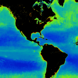
이 제품은 해수면층의 식물성 플랑크톤에 있는 광합성 색소 (클로로필-a)의 농도입니다. 이 데이터 세트는 지연 시간이 3~4일인 지속적인 데이터 세트입니다. GCOM-C는 복사 에너지 수지와 탄소 순환의 변동 뒤에 숨겨진 메커니즘을 설명하기 위해 장기적이고 지속적인 전 세계 관측 및 데이터 수집을 수행합니다.
[null,null,[],[[["\u003cp\u003eThe JAXA/GCOM-C/L3/OCEAN/CHLA/V3 dataset provides global chlorophyll-a concentration data, indicating the amount of phytoplankton in the sea surface layer.\u003c/p\u003e\n"],["\u003cp\u003eData is collected by the GCOM-C satellite with the SGLI sensor, offering global coverage approximately every two days and high spatial resolution.\u003c/p\u003e\n"],["\u003cp\u003eThe dataset is freely available for use with attribution, including commercial purposes, and has a latency of 3-4 days.\u003c/p\u003e\n"],["\u003cp\u003eGCOM-C's mission focuses on understanding long-term changes in the radiation budget and carbon cycle to improve climate prediction accuracy.\u003c/p\u003e\n"],["\u003cp\u003eUsers can explore and analyze this dataset within Google Earth Engine using provided code snippets and visualizations.\u003c/p\u003e\n"]]],["The Global Change Observation Mission (GCOM) provides a dataset (2021-11-29 to 2025-02-20) on chlorophyll-a concentration in phytoplankton at the ocean's surface, collected daily. The data, captured by the SGLI sensor on GCOM-C, is used to study the radiation budget and carbon cycle. The dataset includes the concentration, quality flags, and metadata. Data is accessible via Earth Engine, with free use allowed, and requires proper citation to the Japan Aerospace Exploration Agency.\n"],null,["Dataset Availability\n: 2021-11-29T00:00:00Z--2025-08-29T00:00:00Z\n\nDataset Provider\n:\n\n\n [Global Change Observation Mission (GCOM)](https://suzaku.eorc.jaxa.jp/GCOM/index.html)\n\nCadence\n: 1 Day\n\nTags\n:\n[chla](/earth-engine/datasets/tags/chla) [chlorophyll-a](/earth-engine/datasets/tags/chlorophyll-a) [g-portal](/earth-engine/datasets/tags/g-portal) [gcom](/earth-engine/datasets/tags/gcom) [gcom-c](/earth-engine/datasets/tags/gcom-c) [jaxa](/earth-engine/datasets/tags/jaxa) [ocean](/earth-engine/datasets/tags/ocean) [ocean-color](/earth-engine/datasets/tags/ocean-color) [oceans](/earth-engine/datasets/tags/oceans) \n\nDescription \nThis product is the concentration of the photosynthetic pigment (chlorophyll-a) in phytoplankton\nin the sea surface layer.\n\nThis is an ongoing dataset with a latency of 3-4 days.\n\nGCOM-C conducts long-term and continuous global observation and data collection to elucidate the\nmechanism behind fluctuations in radiation budget and carbon cycle needed to make accurate\nprojections regarding future temperature rise. At the same time, cooperating with research\ninstitutions having a climate numerical model, it contributes to reduction of errors in\ntemperature rise prediction derived from the climate numerical model and improvement of accuracy\nof prediction of various environmental changes. SGLI mounted on GCOM-C is the succession sensor\nof the Global Imager (GLI) mounted on ADEOS-II (MIDORI II) and is the Imaging Radiometer which\nmeasures the radiation from near-ultraviolet to thermal infrared region (380 nm-12 um) in 19\nchannels. Global observation of once for approximately every two days is possible at\nmid-latitude near Japan by observation width at ground greater than 1,000 km. In addition, SGLI\nrealizes high resolution than the similar global sensor and has a polarized observation function\nand a multi-angle observation function.\n\nBands\n\n\n**Pixel Size**\n\n4638.3 meters\n\n**Bands**\n\n| Name | Units | Min | Max | Pixel Size | Description |\n|----------------|---------|-----|--------|------------|-------------------------------------------------------------------------------------------|---|---|---|---|---|---|---|---|---|---|---|---|---|---|---|---|---|---|---|---|---|---|---|---|---|---|---|---|---|---|---|---|---|---|---|---|---|---|---|---|---|---|---|---|---|---|---|---|---|---|---|---|---|---|---|---|---|---|---|---|---|---|---|---|---|---|---|---|---|---|---|---|---|---|---|---|---|---|---|---|---|---|---|---|---|---|---|---|---|---|---|---|---|---|\n| `CHLA_AVE` | mg/m\\^3 | 0\\* | 4000\\* | meters | Concentration of the green pigment (chlorophyll-a) in phytoplankton in sea surface layer. |\n| `CHLA_QA_flag` | | | | meters | CHLA QA |\n| Bitmask for CHLA_QA_flag - Bits 0-1: Terrain type - 0: water (land fraction = 0%) - 1: mostly water (0% \\\u003c land fraction \\\u003c 50%) - 2: mostly coastal (50% \\\u003c land fraction \\\u003c 100%) - 3: land (land fraction = 100%) ||||||||||||||||||||||||||||||||||||||||||||||||||||||||||||||||||||||||||||||||||||||||||||||||||||\n\n\\* estimated min or max value\n\nImage Properties\n\n**Image Properties**\n\n| Name | Type | Description |\n|---------------------|--------|-----------------------------------------------------------------|\n| ALGORITHM_VERSION | STRING | Algorithm version |\n| GRID_INTERVAL | STRING | Spatial resolution |\n| GRID_INTERVAL_UNIT | STRING | Unit of GRID_INTERVAL |\n| IMAGE_END_TIME | STRING | Image acquisition end time |\n| IMAGE_START_TIME | STRING | Image acquisition start time |\n| PROCESSING_RESULT | STRING | Good, Fair, Poor, NG |\n| PROCESSING_UT | STRING | Processing time |\n| PRODUCT_FILENAME | STRING | Source filename |\n| PRODUCT_VERSION | STRING | Product version |\n| SATELLITE_DIRECTION | STRING | Satellite orbit direction - A: Nighttime data - D: Daytime data |\n| CHLA_AVE_OFFSET | STRING | Offset |\n| CHLA_AVE_SLOPE | STRING | Slope |\n\nTerms of Use\n\n**Terms of Use**\n\nThis dataset is free to use without any restrictions (including commercial use). Anyone wishing\nto publish analyzed results or value added data products should properly credit the original\nG-Portal data, e.g., \"PR data by Japan Aerospace Exploration Agency\". For value added data\nproducts, please indicate the credit of the original G-Portal data, e.g., \"Original data for\nthis value added data product was provided by Japan Aerospace Exploration Agency.\"\n\nSee [G-Portal's terms of service (Article 7)](https://gportal.jaxa.jp/gpr/index/eula?lang=en)\nfor additional information.\n\nCitations \nCitations:\n\n- Murakami, H. (Jan. 2020). ATBD of GCOM-C chlorophyll-a concentration algorithm (Version 2).\n Retrieved from \u003chttps://suzaku.eorc.jaxa.jp/GCOM_C/data/ATBD/ver2/V2ATBD_O3AB_Chla_Murakami.pdf\u003e\n\nExplore with Earth Engine **Important:** Earth Engine is a platform for petabyte-scale scientific analysis and visualization of geospatial datasets, both for public benefit and for business and government users. Earth Engine is free to use for research, education, and nonprofit use. To get started, please [register for Earth Engine access.](https://console.cloud.google.com/earth-engine)\n\nCode Editor (JavaScript) \n\n```javascript\nvar dataset = ee.ImageCollection('JAXA/GCOM-C/L3/OCEAN/CHLA/V3')\n .filterDate('2021-12-01', '2022-01-01')\n // filter to daytime data only\n .filter(ee.Filter.eq('SATELLITE_DIRECTION', 'D'));\n\n// Multiply with slope coefficient\nvar image = dataset.mean().multiply(0.0016).log10();\n\nvar vis = {\n bands: ['CHLA_AVE'],\n min: -2,\n max: 2,\n palette: [\n '3500a8','0800ba','003fd6',\n '00aca9','77f800','ff8800',\n 'b30000','920000','880000'\n ]\n};\n\nMap.addLayer(image, vis, 'Chlorophyll-a concentration');\n\nMap.setCenter(128.45, 33.33, 5);\n```\n[Open in Code Editor](https://code.earthengine.google.com/?scriptPath=Examples:Datasets/JAXA/JAXA_GCOM-C_L3_OCEAN_CHLA_V3) \n[GCOM-C/SGLI L3 Chlorophyll-a Concentration (V3)](/earth-engine/datasets/catalog/JAXA_GCOM-C_L3_OCEAN_CHLA_V3) \nThis product is the concentration of the photosynthetic pigment (chlorophyll-a) in phytoplankton in the sea surface layer. This is an ongoing dataset with a latency of 3-4 days. GCOM-C conducts long-term and continuous global observation and data collection to elucidate the mechanism behind fluctuations in radiation budget and carbon cycle ... \nJAXA/GCOM-C/L3/OCEAN/CHLA/V3, chla,chlorophyll-a,g-portal,gcom,gcom-c,jaxa,ocean,ocean-color,oceans \n2021-11-29T00:00:00Z/2025-08-29T00:00:00Z \n-90 -180 90 180 \nGoogle Earth Engine \nhttps://developers.google.com/earth-engine/datasets\n\n- [](https://doi.org/https://suzaku.eorc.jaxa.jp/GCOM/index.html)\n- [](https://doi.org/https://developers.google.com/earth-engine/datasets/catalog/JAXA_GCOM-C_L3_OCEAN_CHLA_V3)"]]