- Disponibilidade de conjuntos de dados
- 2014-03-01T00:00:00Z–2026-01-04T14:00:00Z
- Provedor de conjunto de dados
- Centro de Pesquisa de Observação da Terra da JAXA
- Cadência
- 1 hora
- Tags
Descrição
O Global Satellite Mapping of Precipitation (GSMaP) fornece uma taxa global de chuva por hora com uma resolução de 0,1 x 0,1 grau. O GSMaP é um produto da missão Global Precipitation Measurement (GPM), que fornece observações globais de precipitação em intervalos de três horas. Os valores são estimados usando radiômetros passivos de micro-ondas e infravermelho de várias bandas do satélite GPM Core Observatory e com a ajuda de uma constelação de outros satélites. O algoritmo de recuperação da taxa de precipitação do GPM é baseado em um modelo de transferência radiativa. A taxa ajustada pelo medidor é calculada com base na otimização do acúmulo de 24 horas da taxa de chuva horária do GSMaP para precipitação diária pela medição do medidor da NOAA/CPC. Esse conjunto de dados é processado pela versão 7 do algoritmo GSMaP (versão 4 do produto). Consulte a documentação técnica do GSMaP para mais detalhes.
Esse conjunto de dados contém produtos provisórios GSMaP_NRT que são substituídos regularmente por versões atualizadas quando os dados GSMaP_MVK ficam disponíveis. Os produtos são marcados com uma propriedade de metadados chamada "status". Quando um produto é disponibilizado inicialmente, o valor da propriedade é "provisional". Depois que um produto provisório é atualizado com a versão final, esse valor é atualizado para "permanente". Para mais informações, consulte a Documentação geral
Bandas
Tamanho do pixel
111,32 metros
Bandas
| Nome | Unidades | Mín. | Máx. | Tamanho do pixel | Descrição | ||||||||||||||||||||||||||||||||||||||||||||||||||||||||||||||||||||||||||||||||||||||||||||||
|---|---|---|---|---|---|---|---|---|---|---|---|---|---|---|---|---|---|---|---|---|---|---|---|---|---|---|---|---|---|---|---|---|---|---|---|---|---|---|---|---|---|---|---|---|---|---|---|---|---|---|---|---|---|---|---|---|---|---|---|---|---|---|---|---|---|---|---|---|---|---|---|---|---|---|---|---|---|---|---|---|---|---|---|---|---|---|---|---|---|---|---|---|---|---|---|---|---|---|---|
hourlyPrecipRate |
mm/h | 0* | 204,88* | metros | Resumo da taxa de precipitação por hora |
||||||||||||||||||||||||||||||||||||||||||||||||||||||||||||||||||||||||||||||||||||||||||||||
hourlyPrecipRateGC |
mm/h | 0* | 200,36* | metros | Snapshot da taxa de precipitação horária ajustada ao pluviômetro |
||||||||||||||||||||||||||||||||||||||||||||||||||||||||||||||||||||||||||||||||||||||||||||||
observationTimeFlag |
h | -124,72* | 16.06* | metros | Tempo relativo desde o horário de início do arquivo até o horário de observação do radiômetro de micro-ondas (gerador de imagens/sondador). Se não houver uma observação na janela horária, o tempo será o número negativo de horas desde a última observação. |
||||||||||||||||||||||||||||||||||||||||||||||||||||||||||||||||||||||||||||||||||||||||||||||
satelliteInfoFlag |
metros | Satélite/sensor usado |
|||||||||||||||||||||||||||||||||||||||||||||||||||||||||||||||||||||||||||||||||||||||||||||||||
gaugeQualityInfo |
contagem/d | 0* | 121* | metros | Existência de ajuste de medidor quando o status é "provisório". 1 indica ajustado e 0 indica não ajustado. Quando o status é "permanente", o valor do pixel é a média diária do número de indicadores usados para ajuste no pixel. |
||||||||||||||||||||||||||||||||||||||||||||||||||||||||||||||||||||||||||||||||||||||||||||||
Propriedades da imagem
Propriedades de imagens
| Nome | Tipo | Descrição |
|---|---|---|
| AlgorithmID | STRING | O algoritmo que gerou este produto, por exemplo, 3GSMAPH |
| AlgorithmVersion | STRING | A versão do algoritmo que gerou este produto. |
| ProductVersion | STRING | A versão dos dados atribuída pelo sistema de tratamento |
| GenerationDateTime | STRING | A data e a hora em que este grânulo foi gerado |
| status | STRING | Permanente ou provisório |
Termos de Uso
Termos de Uso
Qualquer pessoa que queira publicar resultados usando os dados do Sistema Global de Monitoramento de Chuvas da JAXA precisa reconhecer claramente a propriedade dos dados na publicação. Por exemplo, o "Mapa Global de Chuvas em Tempo Quase Real (GSMaP_NRT) da JAXA Global Rainfall Watch" foi produzido e distribuído pelo Centro de Pesquisa de Observação da Terra da Agência de Exploração Aeroespacial do Japão. Se você se beneficiou dos produtos de precipitação do GSMaP, cite os principais artigos listados abaixo. Para mais informações, acesse a Política do site da JAXA e o Guia do usuário.
Citações
Kubota, T., K. Aonashi, T. Ushio, S. Shige, Y. N. Takayabu, M. Kachi, Y. Arai, T. Tashima, T. Masaki, N. Kawamoto, T. Mega, M. K. Yamamoto, A. Hamada, M. Yamaji, G. Liu e R. Oki 2020: Global Satellite Mapping of Precipitation (GSMaP) products in the GPM era, Satellite precipitation measurement, Springer, https://doi.org/10.1007/978-3-030-24568-9_20.
DOIs
Explore com o Earth Engine
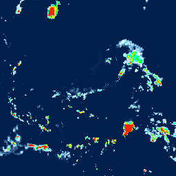
Editor de código (JavaScript)
var dataset = ee.ImageCollection('JAXA/GPM_L3/GSMaP/v7/operational')
                  .filter(ee.Filter.date('2023-09-10', '2023-09-11'));
var precipitation = dataset.select('hourlyPrecipRate');
var precipitationVis = {
  min: 0.0,
  max: 10.0,
  palette:
      ['1621a2', 'ffffff', '03ffff', '13ff03', 'efff00', 'ffb103', 'ff2300'],
};
Map.setCenter(-90.7, 26.12, 3);
Map.addLayer(precipitation, precipitationVis, 'Precipitation');