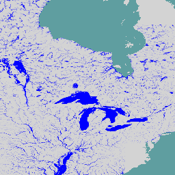
전 세계 하천 홍수 위험 지도는 7가지 다른 홍수 재발 주기(10년에 한 번에서 500년에 한 번)에 대해 하천 네트워크를 따라 침수를 나타내는 그리드 데이터 세트입니다. 새 지도의 입력 하천 흐름 데이터는 오픈소스 수문학 모델 LISFLOOD를 사용하여 생성되며, 침수 시뮬레이션은 수력학 모델 LISFLOOD-FP를 사용하여 실행됩니다. 범위는 그린란드와 남극, 강 유역이 500km^2보다 작은 소규모 섬을 제외한 전 세계를 포함합니다.
셀 값은 수심 (미터)을 나타냅니다. 이 지도는 인구와 경제 자산의 하천 홍수 노출을 평가하고 홍수 위험 평가를 수행하는 데 사용할 수 있습니다. 이 데이터 세트는 Copernicus Emergency Management Service의 일부로 생성됩니다.
대역
픽셀 크기 1,000미터
대역
이름
단위
최소
최대
픽셀 크기
설명
depth
m
0.1
9494.89
미터
홍수 침수 깊이
이미지 속성
이미지 속성
이름
유형
설명
return_period
INT
홍수 반환 기간(년)입니다.
id
INT
위도/경도 그리드 셀의 고유 식별자입니다.
이용약관
이용약관
JRC 데이터 세트는 사용 또는 배포에 제한이 없습니다. 자세한 내용은 액세스 권한을 확인하세요.
인용
인용:
Baugh, Calum; Colonese, Juan; D'Angelo, Claudia; Dottori, Francesco;
Neal, Jeffrey; Prudhomme, Christel; Salamon, Peter (2024): Global river
flood hazard maps. European Commission, Joint Research Centre (JRC)
[데이터 세트] PID:
http://data.europa.eu/89h/jrc-floods-floodmapgl_rp50y-tif
전 세계 하천 홍수 위험 지도는 7가지 다른 홍수 재발 주기 (10년에 한 번에서 500년에 한 번)에 대해 하천 네트워크를 따라 침수를 나타내는 그리드 데이터 세트입니다. 새 지도의 입력 하천 흐름 데이터는 오픈소스 수문학 모델 LISFLOOD를 통해 생성되며, 침수 시뮬레이션은 …
[null,null,[],[[["\u003cp\u003eThe JRC Global River Flood Hazard Maps dataset provides global inundation data for seven flood return periods, ranging from 1-in-10-years to 1-in-500-years.\u003c/p\u003e\n"],["\u003cp\u003eThe dataset utilizes the LISFLOOD and LISFLOOD-FP models to simulate river flow and inundation, respectively, and covers the entire world except for Greenland, Antarctica, and small islands with river basins smaller than 500 km².\u003c/p\u003e\n"],["\u003cp\u003eCell values in the dataset represent water depth in meters, allowing for assessment of population and economic asset exposure to river floods.\u003c/p\u003e\n"],["\u003cp\u003eCreated by the Copernicus Emergency Management Service, the dataset is freely available for use and distribution without restrictions.\u003c/p\u003e\n"],["\u003cp\u003eThe dataset can be explored and analyzed using Google Earth Engine, a platform for scientific analysis and visualization of geospatial datasets.\u003c/p\u003e\n"]]],["The Joint Research Centre provides global river flood hazard maps, available from March 16, 2024. These maps, part of the Copernicus Emergency Management Service, depict river network inundation for seven flood return periods, utilizing the LISFLOOD and LISFLOOD-FP models. Cell values indicate water depth in meters with 1000 meters pixel size. Users can assess population and asset exposure to floods. The dataset is freely accessible, and an Earth Engine code snippet is provided for visualization.\n"],null,["# JRC Global River Flood Hazard Maps Version 1 [deprecated]\n\nDataset Availability\n: 2024-03-16T00:00:00Z--2024-03-16T23:59:59Z\n\nDataset Provider\n:\n\n\n [Joint Research Centre](https://data.jrc.ec.europa.eu/dataset/jrc-floods-floodmapgl_rp50y-tif)\n\nTags\n:\n[flood](/earth-engine/datasets/tags/flood) [monitoring](/earth-engine/datasets/tags/monitoring) [surface-ground-water](/earth-engine/datasets/tags/surface-ground-water) [wri](/earth-engine/datasets/tags/wri) \n\n#### Description\n\nThe global river flood hazard maps are a gridded data set representing\ninundation along the river network, for seven different flood return periods\n(from 1-in-10-years to 1-in-500-years). The input river flow data for the\nnew maps are produced by means of the open-source hydrological model\nLISFLOOD, while inundation simulations are performed with the hydrodynamic\nmodel LISFLOOD-FP. The extent comprises the entire world with the exception\nof Greenland and Antarctica and small islands with river basins smaller than\n500 km\\^2.\n\nCell values indicate water depth (in meters). The maps can be used to assess\nthe exposure of population and economic assets to river floods, and to\nperform flood risk assessments. The dataset is created as part of the\nCopernicus Emergency Management Service.\n| **Note:** This dataset may have missing tiles. This collection will be eventually be replaced by v2.1 once it's updated by the provider.\n\n### Bands\n\n\n**Pixel Size**\n\n1000 meters\n\n**Bands**\n\n| Name | Units | Min | Max | Pixel Size | Description |\n|---------|-------|-----|---------|------------|------------------------|\n| `depth` | m | 0.1 | 9494.89 | meters | Flood inundation depth |\n\n### Image Properties\n\n**Image Properties**\n\n| Name | Type | Description |\n|---------------|------|---------------------------------------------------------------------------------------------------------------------------------|\n| return_period | INT | Return period of flood in years. | **Note:** This property is not present for images that just show the permanent water bodies. |\n| id | INT | Unique identifier for the latitude/longitude grid cell. |\n\n### Terms of Use\n\n**Terms of Use**\n\nThe JRC datasets are available without restriction\non use or distribution. For more information check\n[access rights](https://data.jrc.ec.europa.eu/access-rights/no-limitations),\n\n### Citations\n\nCitations:\n\n- Baugh, Calum; Colonese, Juan; D'Angelo, Claudia; Dottori, Francesco;\n Neal, Jeffrey; Prudhomme, Christel; Salamon, Peter (2024): Global river\n flood hazard maps. European Commission, Joint Research Centre (JRC)\n \\[Dataset\\] PID:\n \u003chttp://data.europa.eu/89h/jrc-floods-floodmapgl_rp50y-tif\u003e\n\n### DOIs\n\n- \u003chttps://doi.org/10.1016/j.advwatres.2016.05.002\u003e\n\n### Explore with Earth Engine\n\n| **Important:** Earth Engine is a platform for petabyte-scale scientific analysis and visualization of geospatial datasets, both for public benefit and for business and government users. Earth Engine is free to use for research, education, and nonprofit use. To get started, please [register for Earth Engine access.](https://console.cloud.google.com/earth-engine)\n\n### Code Editor (JavaScript)\n\n```javascript\nvar dataset = ee.ImageCollection('JRC/CEMS_GLOFAS/FloodHazard/v1');\nvar depth = dataset.select('depth');\nvar depthVis = {\n min: 0,\n max: 1,\n palette: ['ffffff','0000ff'],\n};\nMap.setCenter(-86.47, 47.28, 4);\nMap.addLayer(depth, depthVis, 'JRC Flood Hazard Maps');\n```\n[Open in Code Editor](https://code.earthengine.google.com/?scriptPath=Examples:Datasets/JRC/JRC_CEMS_GLOFAS_FloodHazard_v1) \n[JRC Global River Flood Hazard Maps Version 1 \\[deprecated\\]](/earth-engine/datasets/catalog/JRC_CEMS_GLOFAS_FloodHazard_v1) \nThe global river flood hazard maps are a gridded data set representing inundation along the river network, for seven different flood return periods (from 1-in-10-years to 1-in-500-years). The input river flow data for the new maps are produced by means of the open-source hydrological model LISFLOOD, while inundation simulations are ... \nJRC/CEMS_GLOFAS/FloodHazard/v1, flood,monitoring,surface-ground-water,wri \n2024-03-16T00:00:00Z/2024-03-16T23:59:59Z \n-90 -180 90 180 \nGoogle Earth Engine \nhttps://developers.google.com/earth-engine/datasets\n\n- [https://doi.org/10.1016/j.advwatres.2016.05.002](https://doi.org/https://data.jrc.ec.europa.eu/dataset/jrc-floods-floodmapgl_rp50y-tif)\n- [https://doi.org/10.1016/j.advwatres.2016.05.002](https://doi.org/https://developers.google.com/earth-engine/datasets/catalog/JRC_CEMS_GLOFAS_FloodHazard_v1)"]]