- Disponibilidade de conjuntos de dados
- 2018-01-01T00:00:00Z–2022-01-01T00:00:00Z
- Provedor de conjunto de dados
- Joint Research Center (JRC)
- Cadência
- 1 ano
- Tags
Descrição
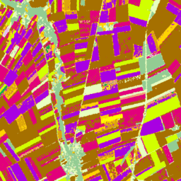
Mapas de tipos de culturas europeias com base em observações in situ do Sentinel-1 e do LUCAS Copernicus 2018 para 2018, além de uma combinação de dados auxiliares do Sentinel-1 e do Sentinel-2 com observações do LUCAS Copernicus 2022 para 2022.
Com base na pesquisa in situ do LUCAS 2018 Copernicus (link em inglês), esse conjunto de dados representa o primeiro mapa de tipo de cultura em escala da UE com resolução de 10 m, que foi derivado exclusivamente de observações de radar de abertura sintética S1A e S1B. O conjunto de dados de 2022 continua esse esforço usando uma abordagem de várias fontes que combina imagens do Sentinel-1 e do Sentinel-2 com dados de temperatura e elevação, com suporte das observações do LUCAS 2022.
Bandas
Tamanho do pixel
10 metros
Bandas
| Nome | Tamanho do pixel | Descrição |
|---|---|---|
classification |
metros | Classificação principal de cobertura da terra específica da cultura. |
Tabela de classes de classificação
| Valor | Cor | Descrição |
|---|---|---|
| 100 | #ff130f | inteligência |
| 211 | #a57000 | Trigo comum |
| 212 | #896054 | Trigo durum |
| 213 | #e2007c | Barley |
| 214 | #aa007c | Rye |
| 215 | #a05989 | Aveia |
| 216 | #ffd300 | Maize |
| 217 | #00a8e2 | Rice |
| 218 | #d69ebc | Triticale |
| 219 | #d69ebc | Outros cereais |
| 221 | #dda50a | Batatas |
| 222 | #a800e2 | Beterraba |
| 223 | #00af49 | Outras raízes |
| 230 | #00af49 | Outras culturas industriais não permanentes |
| 231 | #ffff00 | Girassol |
| 232 | #d1ff00 | Colza e colza nabo |
| 233 | #267000 | Soya |
| 240 | #f2a377 | Leguminosas secas |
| 250 | #e8bfff | Culturas forrageiras (cereais e leguminosas) |
| 290 | #696969 | Terra arável sem vegetação |
| 300 | #93cc93 | Florestas e arbustais (incluindo culturas permanentes) |
| 500 | #e8ffbf | Campos |
| 600 | #a89e7f | Terra nua/musgo de líquens |
| 700 | #0793de | Água |
| 800 | #7cafaf | Pântanos |
Propriedades de imagens
Propriedades da imagem
| Nome | Tipo | Descrição |
|---|---|---|
| classification_class_names | STRING_LIST | Matriz de nomes de classificação de lavouras. |
| classification_class_palette | STRING_LIST | Matriz de strings de cores de código hexadecimal usadas para a paleta de classificação. |
| classification_class_values | INT_LIST | Valor da classificação de lavoura. |
Termos de Uso
Termos de Uso
Citações
d'Andrimont, R., Verhegghen, A., Lemoine, G., Kempeneers, P., Meroni, M., & Van der Velde, M. (2021). Da parcela à escala continental: um primeiro mapa europeu de tipo de cultura com base em observações in situ do Sentinel-1 e do LUCAS Copernicus. Remote sensing of environment, 266, 112708.
d'Andrimont, R., Verhegghen, A., Lemoine, G., Kempeneers, P., Meroni, M., & Van der Velde, M. (2021). Da parcela à escala continental: um primeiro mapa europeu de tipo de cultura com base em observações in situ do Sentinel-1 e do LUCAS Copernicus. Remote sensing of environment, 266, 112708. doi:10.1016/j.rse.2021.112708.
Ghassemi, B., Izquierdo-Verdiguier, E., Verhegghen, A., Yordanov, M., Lemoine, G., Moreno Martínez, Á., De Marchi, D., van der Velde, M., Vuolo, F. and d’Andrimont, R., 2024. Mapa de culturas da União Europeia em 2022: observação da Terra com resolução de 10 metros para analisar a diversidade de plantações na Europa. Scientific Data, 11(1), p.1048. 10.1038/s41597-024-03884-y
DOIs
Explorar com o Earth Engine
Editor de código (JavaScript)
var image = ee.ImageCollection('JRC/D5/EUCROPMAP/V1').filterDate(
    '2018-01-01', '2019-01-01').first();
Map.addLayer(image, {}, 'EUCROPMAP 2018');
Map.setCenter(10, 48, 4);