- Disponibilidade de conjuntos de dados
- 1984-03-16T00:00:00Z–2022-01-01T00:00:00Z
- Provedor de conjunto de dados
- EC JRC / Google
- Cadência
- 1 mês
- Tags
Descrição
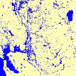
Esse conjunto de dados contém mapas da distribuição espacial e temporal de água superficial de 1984 a 2021 e fornece estatísticas sobre a extensão e a mudança dessas superfícies de água. Para mais informações, consulte o artigo de revista associado: Mapeamento de alta resolução da água superficial global e suas mudanças de longo prazo (Nature, 2016) e o Guia para usuários de dados on-line.
Esses dados foram gerados usando 4.716.475 cenas do Landsat 5, 7 e 8 adquiridas entre 16 de março de 1984 e 31 de dezembro de 2021. Cada pixel foi classificado individualmente como água / não água usando um sistema especializado, e os resultados foram reunidos em um histórico mensal para todo o período e duas épocas (1984-1999, 2000-2021) para detecção de mudanças.
Essa coleção de histórico mensal contém todo o histórico de detecção de água mês a mês. A coleção contém 454 imagens, uma para cada mês entre março de 1984 e dezembro de 2021.
Bandas
Tamanho do pixel
30 metros
Bandas
| Nome | Tamanho do pixel | Descrição | |||||||||||||||||||||||||||||||||||||||||||||||||||||||||||||||||||||||||||||||||||||||||||||||||
|---|---|---|---|---|---|---|---|---|---|---|---|---|---|---|---|---|---|---|---|---|---|---|---|---|---|---|---|---|---|---|---|---|---|---|---|---|---|---|---|---|---|---|---|---|---|---|---|---|---|---|---|---|---|---|---|---|---|---|---|---|---|---|---|---|---|---|---|---|---|---|---|---|---|---|---|---|---|---|---|---|---|---|---|---|---|---|---|---|---|---|---|---|---|---|---|---|---|---|---|
water |
metros | Detecção de água do mês. |
|||||||||||||||||||||||||||||||||||||||||||||||||||||||||||||||||||||||||||||||||||||||||||||||||
Propriedades de imagens
Propriedades da imagem
| Nome | Tipo | Descrição |
|---|---|---|
| mês | DOUBLE | Mês |
| ano | DOUBLE | Ano |
Termos de Uso
Termos de Uso
Todos os dados aqui são produzidos no âmbito do Programa Copernicus e são fornecidos sem custo financeiro, sem restrição de uso. Para informações completas sobre a licença, consulte o Regulamento do Copernicus.
Publicações, modelos e produtos de dados que usam esses conjuntos de dados precisam incluir o reconhecimento adequado, citando os conjuntos de dados e o artigo do periódico, como na citação a seguir.
Se você estiver usando os dados como uma camada em um mapa publicado, inclua o seguinte texto de atribuição: "Fonte: EC JRC/Google"
Citações
Jean-Francois Pekel, Andrew Cottam, Noel Gorelick, Alan S. Belward, High-resolution mapping of global surface water and its long-term changes. Nature 540, 418-422 (2016). (doi:10.1038/nature20584)
Explorar com o Earth Engine
Editor de código (JavaScript)
var dataset = ee.Image('JRC/GSW1_4/MonthlyHistory/2020_06');

var visualization = {
  bands: ['water'],
  min: 0.0,
  max: 2.0,
  palette: ['ffffff', 'fffcb8', '0905ff']
};

Map.setCenter(-121.234, 38.109, 7);

Map.addLayer(dataset, visualization, 'Water');