- 데이터 세트 사용 가능 기간
- 2017-01-01T00:00:00Z–2018-01-01T00:00:00Z
- 데이터 세트 제공업체
- K. 북 Toosi University of Technology LiDAR Lab
- 태그
설명
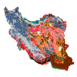
이란 전역의 토지 피복 지도는 Google Earth Engine Cloud 플랫폼 내에서 Sentinel 이미지를 처리하여 생성되었습니다. 이를 위해 2017년의 단일 모자이크 데이터 세트를 생성하기 위해 2,500개가 넘는 Sentinel-1 이미지와 11,000개가 넘는 Sentinel-2 이미지가 처리되었습니다. 그런 다음 13개 클래스의 많은 참조 샘플로 객체 기반 랜덤 포레스트 분류 방법을 학습시켜 이란 전역 토지 피복 지도를 생성했습니다.
대역
대역
| 이름 | 픽셀 크기 | 설명 |
|---|---|---|
classification |
10미터 | 분류 |
분류 클래스 표
| 값 | 색상 | 설명 |
|---|---|---|
| 1 | #000000 | 도시 |
| 2 | #006eff | 물 |
| 3 | #41a661 | 습지대 |
| 4 | #ff7f7f | Kalut (yardang) |
| 5 | #bee8ff | Marshland |
| 6 | #ff00c5 | Salty Land |
| 7 | #ff0000 | 클레이 |
| 8 | #00734c | 숲 |
| 9 | #732600 | 노두 |
| 10 | #ffaa00 | Uncovered Plain |
| 11 | #d3ffbe | 모래 |
| 12 | #446589 | 농지 |
| 13 | #cccccc | Range Land |
이용약관
이용약관
Arsalan Ghorbanian, Mohammad Kakooei, Meisam Amani, Sahel Mahdavi, Ali Mohammadzadeh, Mahdi Hasanlou의 'Iran Land Cover Map v1 13-class (2017)'은 크리에이티브 커먼즈 저작자표시 4.0 국제 라이선스 (CC BY 4.0)에 따라 이용할 수 있습니다.
인용
Ghorbanian, A., Kakooei, M., Amani, M., Mahdavi, S., Mohammadzadeh, A., & Hasanlou, M. (2020). Google Earth Engine 내에서 Sentinel 이미지를 사용하고 이전된 학습 샘플을 사용하는 토지 피복 분류를 위한 새로운 자동 워크플로를 사용하여 이란의 토지 피복 지도를 개선했습니다. ISPRS Journal of Photogrammetry and Remote Sensing, 167, 276-288. doi:10.1016/j.isprsjprs.2020.07.013
Earth Engine으로 탐색하기
코드 편집기(JavaScript)
var dataset = ee.Image('KNTU/LiDARLab/IranLandCover/V1');

var visualization = {
  bands: ['classification']
};

Map.setCenter(54.0, 33.0, 5);

Map.addLayer(dataset, visualization, 'Classification');