- Disponibilidade de conjuntos de dados
- 2017-01-01T00:00:00Z–2018-01-01T00:00:00Z
- Provedor de conjunto de dados
- K. N. Toosi University of Technology LiDAR Lab
- Tags
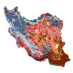
Descrição
O mapa de cobertura da terra em todo o Irã foi gerado processando imagens do Sentinel na plataforma de nuvem do Google Earth Engine. Para isso, mais de 2.500 imagens do Sentinel-1 e mais de 11.000 do Sentinel-2 foram processadas para produzir um único conjunto de dados de mosaico para o ano de 2017. Em seguida, um método de classificação de floresta aleatória baseado em objetos foi treinado por um grande número de amostras de referência para 13 classes, gerando o mapa de cobertura da terra em todo o Irã.
Bandas
Bandas
| Nome | Tamanho do pixel | Descrição |
|---|---|---|
classification |
10 metros | Classificação |
Tabela de classe de classificação
| Valor | Cor | Descrição |
|---|---|---|
| 1 | #000000 | Urbana |
| 2 | #006eff | Água |
| 3 | #41a661 | Pântano |
| 4 | #ff7f7f | Kalut (yardang) |
| 5 | #bee8ff | Marshland |
| 6 | #ff00c5 | Salty Land |
| 7 | #ff0000 | Clay |
| 8 | #00734c | Floresta |
| 9 | #732600 | Outcrop |
| 10 | #ffaa00 | Planície descoberta |
| 11 | #d3ffbe | Areia |
| 12 | #446589 | Terra agrícola |
| 13 | #cccccc | Range Land |
Termos de Uso
Termos de Uso
Este trabalho "Mapa de cobertura da terra do Irã v1 13 classes (2017)" de Arsalan Ghorbanian, Mohammad Kakooei, Meisam Amani, Sahel Mahdavi, Ali Mohammadzadeh, Mahdi Hasanlou está licenciado sob a Licença internacional Creative Commons Atribuição 4.0 (CC BY 4.0)
Citações
Ghorbanian, A., Kakooei, M., Amani, M., Mahdavi, S., Mohammadzadeh, A., & Hasanlou, M. (2020). Mapa de cobertura da terra aprimorado do Irã usando imagens do Sentinel no Google Earth Engine e um novo fluxo de trabalho automático para classificação da cobertura da terra usando amostras de treinamento migradas. ISPRS Journal of Photogrammetry and Remote Sensing, 167, 276-288. doi:10.1016/j.isprsjprs.2020.07.013
Explorar com o Earth Engine
Editor de código (JavaScript)
var dataset = ee.Image('KNTU/LiDARLab/IranLandCover/V1');

var visualization = {
  bands: ['classification']
};

Map.setCenter(54.0, 33.0, 5);

Map.addLayer(dataset, visualization, 'Classification');