- ডেটাসেটের প্রাপ্যতা
- ১৯৭২-০৭-২৫T০০:০০:০০Z–১৯৮৩-০২-২০T০০:০০:০০Z
- ডেটাসেট প্রযোজক
- ইউএসজিএস
- ট্যাগ
বর্ণনা
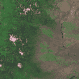
গ্লোবাল ল্যান্ড সার্ভে (জিএলএস) ১৯৭৫ হলো ল্যান্ডস্যাট মাল্টিস্পেকট্রাল স্ক্যানার (এমএসএস) থেকে প্রাপ্ত চিত্রাবলীর একটি বৈশ্বিক সংগ্রহ। বেশিরভাগ দৃশ্য ১৯৭২-১৯৮৩ সালের মধ্যে ল্যান্ডস্যাট ১-৩ দ্বারা ধারণ করা হয়েছিল। ল্যান্ডস্যাট ১-৩ ডেটার কিছু শূন্যস্থান ১৯৮২-১৯৮৭ সালের মধ্যে ল্যান্ডস্যাট ৪-৫ দ্বারা ধারণ করা দৃশ্যাবলী দিয়ে পূরণ করা হয়েছে। এই ডেটাতে ৪টি স্পেকট্রাল ব্যান্ড রয়েছে: সবুজ, লাল, একটি এনআইআর (NIR) ব্যান্ড এবং একটি এসডব্লিউআইআর (SWIR) ব্যান্ড। প্রচলিত ফলস-কালার উপস্থাপনায়, ছবিগুলো লাল দেখায় কারণ এনআইআর ব্যান্ডটি লাল হিসেবে প্রদর্শিত হয়ে গাছপালাকে বিশেষভাবে ফুটিয়ে তোলে।
ব্যান্ড
ব্যান্ড
পিক্সেল সাইজ: ৬০ মিটার (সকল ব্যান্ড)
| নাম | পিক্সেল আকার | তরঙ্গদৈর্ঘ্য | বর্ণনা |
|---|---|---|---|
10 | ৬০ মিটার | ৫০০-৬০০ এনএম | সবুজ |
20 | ৬০ মিটার | ৬০০-৭০০ এনএম | লাল |
30 | ৬০ মিটার | ৭০০-৮০০ এনএম | নিকটবর্তী ইনফ্রারেড |
40 | ৬০ মিটার | ৮০০-১১০০ এনএম | স্বল্প-তরঙ্গদৈর্ঘ্যের ইনফ্রারেড |
ব্যবহারের শর্তাবলী
ব্যবহারের শর্তাবলী
ল্যান্ডস্যাট ডেটাসেটগুলো যুক্তরাষ্ট্রীয়ভাবে তৈরি ডেটা এবং তাই এগুলো পাবলিক ডোমেইনের অন্তর্ভুক্ত। এগুলো কোনো কপিরাইট বিধিনিষেধ ছাড়াই ব্যবহার, হস্তান্তর বা পুনরুৎপাদন করা যেতে পারে।
তথ্যের উৎস হিসেবে ইউএসজিএস (USGS)-এর স্বীকৃতি বা কৃতিত্ব জানাতে হলে, নিচে দেখানো উদাহরণের মতো একটি টেক্সট সাইটেশন লাইন অন্তর্ভুক্ত করতে হবে।
(পণ্য, ছবি, আলোকচিত্র বা ডেটাসেটের নাম) ইউএস জিওলজিক্যাল সার্ভের সৌজন্যে
উদাহরণ: ল্যান্ডস্যাট-৭ চিত্র, সৌজন্যে ইউএস জিওলজিক্যাল সার্ভে।
USGS পণ্যগুলির যথাযথ উদ্ধৃতি এবং স্বীকৃতি প্রদানের বিষয়ে আরও বিস্তারিত তথ্যের জন্য USGS ভিজ্যুয়াল আইডেন্টিটি সিস্টেম নির্দেশিকা দেখুন।
উদ্ধৃতি
জিএলএস ১৯৭৫ ছবিটি ইউএস জিওলজিক্যাল সার্ভের সৌজন্যে প্রাপ্ত।
আর্থ ইঞ্জিন দিয়ে অন্বেষণ করুন
কোড এডিটর (জাভাস্ক্রিপ্ট)
var dataset = ee.ImageCollection('LANDSAT/GLS1975');
var falseColor = dataset.select(['30', '20', '10']);
var falseColorVis = {
  gamma: 1.6,
};
Map.setCenter(44.517, 25.998, 5);
Map.addLayer(falseColor, falseColorVis, 'False Color');