Global Land Survey (GLS) 1975 to globalny zbiór zdjęć z skanera wielospektralnego Landsat (MSS). Większość scen została zarejestrowana przez satelity Landsat 1–3 w latach 1972–1983. Kilka luk w danych z satelitów Landsat 1–3 zostało uzupełnionych scenami zarejestrowanymi przez satelity Landsat 4–5 w latach 1982–1987. Dane te zawierają 4 pasma spektralne: zielone, czerwone, NIR i SWIR. Na typowym zdjęciu w fałszywych kolorach obrazy są czerwone, ponieważ pasmo NIR, wyświetlane jako czerwone, podkreśla roślinność.
Pasma
Rozmiar piksela 60 metrów
Pasma
Nazwa
Rozmiar piksela
Długość fali
Opis
10
metry
500–600 nm
Zielony
20
metry
600–700 nm
Czerwony
30
metry
700-800 nm
Bliska podczerwień
40
metry
800-1100 nm
podczerwień o krótkiej długości fali,
Warunki korzystania z usługi
Zbiory danych Landsat są tworzone przez instytucje federalne, dlatego należą do domeny publicznej i można ich używać, przenosić i reprodukować bez ograniczeń wynikających z praw autorskich.
Należy podać informację o źródle danych USGS, dodając wiersz z cytatem, np. jak w przykładzie poniżej.
(Nazwa produktu, obrazu, zdjęcia lub zbioru danych) dzięki uprzejmości
U.S. Geological Survey
Przykład: zdjęcie Landsat-7 udostępnione przez U.S. Geological Survey
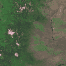
Global Land Survey (GLS) 1975 to globalny zbiór zdjęć z wielospektralnego skanera Landsat (MSS). Większość scen została zarejestrowana przez satelity Landsat 1–3 w latach 1972–1983. Kilka luk w danych z satelitów Landsat 1–3 zostało uzupełnionych scenami zarejestrowanymi przez satelity Landsat 4–5 w latach 1982–1987. Te dane…
[null,null,[],[[["\u003cp\u003eThe Global Land Survey (GLS) 1975 dataset provides global imagery from the Landsat Multispectral Scanner (MSS) primarily acquired by Landsat 1-3 between 1972 and 1983.\u003c/p\u003e\n"],["\u003cp\u003eIt includes four spectral bands (Green, Red, Near Infrared, and Short-wavelength Infrared) with a resolution of 60 meters.\u003c/p\u003e\n"],["\u003cp\u003eLandsat datasets are public domain and can be used freely with proper citation to the U.S. Geological Survey.\u003c/p\u003e\n"],["\u003cp\u003eThe dataset is available in Earth Engine and can be visualized using false color composites highlighting vegetation.\u003c/p\u003e\n"],["\u003cp\u003eGaps in Landsat 1-3 data within the GLS 1975 collection were filled using Landsat 4-5 imagery from 1982-1987.\u003c/p\u003e\n"]]],[],null,["# Landsat Global Land Survey 1975\n\nDataset Availability\n: 1972-07-25T00:00:00Z--1983-02-20T00:00:00Z\n\nDataset Provider\n:\n\n\n [USGS](https://www.usgs.gov/core-science-systems/nli/landsat/global-land-survey-gls)\n\nTags\n:\n[global](/earth-engine/datasets/tags/global) [gls](/earth-engine/datasets/tags/gls) [landsat](/earth-engine/datasets/tags/landsat) [radiance](/earth-engine/datasets/tags/radiance) [satellite-imagery](/earth-engine/datasets/tags/satellite-imagery) [usgs](/earth-engine/datasets/tags/usgs) \n\n#### Description\n\nThe Global Land Survey (GLS) 1975 is a\nglobal collection of imagery from the Landsat Multispectral\nScanner (MSS). Most scenes were acquired by Landsat 1-3\nin 1972-1983. A few gaps in the Landsat 1-3 data\nhave been filled with scenes acquired by Landsat 4-5 during the\nyears 1982-1987. These data contain 4 spectral bands:\nGreen, Red, an NIR band, and a SWIR band. In the typical\nFalse-color presentation, the images appear red because\nthe NIR band, displayed as red, highlights vegetation.\n\n### Bands\n\n\n**Pixel Size**\n\n60 meters\n\n**Bands**\n\n| Name | Pixel Size | Wavelength | Description |\n|------|------------|-------------|---------------------------|\n| `10` | meters | 500-600 nm | Green |\n| `20` | meters | 600-700 nm | Red |\n| `30` | meters | 700-800 nm | Near infrared |\n| `40` | meters | 800-1100 nm | Short-wavelength infrared |\n\n### Terms of Use\n\n**Terms of Use**\n\nLandsat datasets are federally created data\nand therefore reside in the public domain and may be used, transferred, or reproduced without copyright restriction.\n\nAcknowledgement or credit of the USGS as data source should be provided\nby including a line of text citation such as the example shown below.\n\n(Product, Image, Photograph, or Dataset Name) courtesy of\nthe U.S. Geological Survey\n\nExample: Landsat-7 image courtesy of the U.S. Geological Survey\n\nSee the\n[USGS Visual Identity System Guidance](https://www.usgs.gov/information-policies-and-instructions/usgs-visual-identity-system)\nfor further details on proper citation and acknowledgement of USGS products.\n\n### Citations\n\nCitations:\n\n- GLS 1975 image courtesy of the U.S. Geological Survey\n\n### Explore with Earth Engine\n\n| **Important:** Earth Engine is a platform for petabyte-scale scientific analysis and visualization of geospatial datasets, both for public benefit and for business and government users. Earth Engine is free to use for research, education, and nonprofit use. To get started, please [register for Earth Engine access.](https://console.cloud.google.com/earth-engine)\n\n### Code Editor (JavaScript)\n\n```javascript\nvar dataset = ee.ImageCollection('LANDSAT/GLS1975');\nvar falseColor = dataset.select(['30', '20', '10']);\nvar falseColorVis = {\n gamma: 1.6,\n};\nMap.setCenter(44.517, 25.998, 5);\nMap.addLayer(falseColor, falseColorVis, 'False Color');\n```\n[Open in Code Editor](https://code.earthengine.google.com/?scriptPath=Examples:Datasets/LANDSAT/LANDSAT_GLS1975) \n[Landsat Global Land Survey 1975](/earth-engine/datasets/catalog/LANDSAT_GLS1975) \nThe Global Land Survey (GLS) 1975 is a global collection of imagery from the Landsat Multispectral Scanner (MSS). Most scenes were acquired by Landsat 1-3 in 1972-1983. A few gaps in the Landsat 1-3 data have been filled with scenes acquired by Landsat 4-5 during the years 1982-1987. These data ... \nLANDSAT/GLS1975, global,gls,landsat,radiance,satellite-imagery,usgs \n1972-07-25T00:00:00Z/1983-02-20T00:00:00Z \n-90 -180 90 180 \nGoogle Earth Engine \nhttps://developers.google.com/earth-engine/datasets\n\n- [](https://doi.org/https://www.usgs.gov/core-science-systems/nli/landsat/global-land-survey-gls)\n- [](https://doi.org/https://developers.google.com/earth-engine/datasets/catalog/LANDSAT_GLS1975)"]]