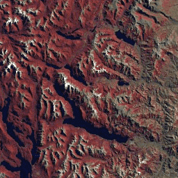
מערך הנתונים GLS2005 הוא אוסף של 9,500 תמונות לוויין ברזולוציה בינונית, שעברו תיקון אורתוגרפי, שצולמו בין 2004 ל-2007 ומכסות את כל שטחי היבשה בכדור הארץ. ב-GLS2005 נעשה שימוש בעיקר בנתוני Landsat 5 ובנתוני Landsat 7 עם מילוי פערים, וגם בנתוני EO-1 ALI ו-Terra ASTER כדי למלא חורים בנתונים.
מערך הנתונים הזה מכיל תמונות רק מהחיישנים L5 TM ו-L7 ETM+, ורק את 6 הפסים שמשותפים לשני החיישנים האלה: 10, 20, 30, 40, 50 ו-70.
תחום תדרים
גודל הפיקסל 30 מטרים
תחום תדרים
שם
גודל הפיקסל
אורך גל
תיאור
10
מטרים
0.45 עד 0.52 מיקרומטר
כחול
20
מטרים
0.52 עד 0.60 מיקרומטר
ירוק
30
מטרים
0.63 - 0.69 מיקרומטר
אדום
40
מטרים
0.76 - 0.90 מיקרומטר
אינפרה-אדום קרוב
50
מטרים
1.55 - 1.75 מיקרומטר
גלים קצרים של אינפרא-אדום 1
70
מטרים
2.08 עד 2.35 מיקרומטר
אינפרה-אדום בגלים קצרים 2
תנאים והגבלות
תנאים והגבלות
מערכי נתונים של Landsat הם נתונים שנוצרו על ידי הממשלה הפדרלית, ולכן הם נחלת הכלל ואפשר להשתמש בהם, להעביר אותם או לשכפל אותם ללא הגבלות של זכויות יוצרים.
צריך לציין את ה-USGS כמקור הנתונים, למשל באמצעות שורת ציטוט כמו בדוגמה שמוצגת בהמשך.
(Product, Image, Photograph, or Dataset Name) courtesy of
the U.S. Geological Survey
דוגמה: תמונה של Landsat-7 באדיבות הסקר הגאולוגי של ארה"ב
מערך הנתונים GLS2005 הוא אוסף של 9,500 תמונות לוויין ברזולוציה בינונית שעברו תיקון אורתוגרפי, שצולמו בין 2004 ל-2007 ומכסות את כל שטחי היבשה בכדור הארץ. ב-GLS2005 נעשה שימוש בעיקר בנתונים מ-Landsat 5 ומ-Landsat 7 עם מילוי פערים, וגם בנתונים מ-EO-1 ALI ומ-Terra ASTER כדי למלא חורים בנתונים. מערך הנתונים הזה מכיל …
[null,null,[],[[["\u003cp\u003eThe GLS2005 dataset comprises approximately 9,500 orthorectified, medium-resolution satellite images of Earth's landmasses, collected between 2004 and 2007.\u003c/p\u003e\n"],["\u003cp\u003ePrimarily using Landsat 5 and 7 data, GLS2005 also incorporates EO-1 ALI and Terra ASTER data to fill gaps, offering a comprehensive global land survey.\u003c/p\u003e\n"],["\u003cp\u003eThis dataset includes six spectral bands (blue, green, red, near-infrared, and two shortwave infrared bands) at a 30-meter resolution, compatible with both Landsat 5 TM and Landsat 7 ETM+ sensors.\u003c/p\u003e\n"],["\u003cp\u003eGLS2005 data is freely available for use, transfer, and reproduction without copyright restrictions, as it is considered public domain data created by the USGS.\u003c/p\u003e\n"],["\u003cp\u003eUsers are encouraged to acknowledge the USGS as the data source when utilizing GLS2005 imagery.\u003c/p\u003e\n"]]],[],null,["# Landsat Global Land Survey 2005, Landsat 5+7 scenes\n\nDataset Availability\n: 2003-07-29T00:00:00Z--2008-07-29T00:00:00Z\n\nDataset Provider\n:\n\n\n [USGS](https://www.usgs.gov/landsat-missions/global-land-survey-gls)\n\nTags\n:\n[gls](/earth-engine/datasets/tags/gls) [landsat](/earth-engine/datasets/tags/landsat) [radiance](/earth-engine/datasets/tags/radiance) [satellite-imagery](/earth-engine/datasets/tags/satellite-imagery) [usgs](/earth-engine/datasets/tags/usgs) \n\n#### Description\n\nThe GLS2005 data set is a collection of 9500\northorectified leaf-on medium-resolution satellite images collected between\n2004 and 2007 and covering the Earth's land masses. GLS2005 uses mainly Landsat\n5 and gap-filled Landsat 7 data with EO-1 ALI and Terra ASTER data filling in\nany data holes.\n\nThis dataset contains images from just the L5 TM and L7 ETM+ sensors, and only the 6 bands that those two sensors have in common: 10, 20, 30, 40, 50, and 70.\n\n### Bands\n\n\n**Pixel Size**\n\n30 meters\n\n**Bands**\n\n| Name | Pixel Size | Wavelength | Description |\n|------|------------|----------------|----------------------|\n| `10` | meters | 0.45 - 0.52 μm | Blue |\n| `20` | meters | 0.52 - 0.60 μm | Green |\n| `30` | meters | 0.63 - 0.69 μm | Red |\n| `40` | meters | 0.76 - 0.90 μm | Near infrared |\n| `50` | meters | 1.55 - 1.75 μm | Shortwave infrared 1 |\n| `70` | meters | 2.08 - 2.35 μm | Shortwave infrared 2 |\n\n### Terms of Use\n\n**Terms of Use**\n\nLandsat datasets are federally created data\nand therefore reside in the public domain and may be used, transferred, or reproduced without copyright restriction.\n\nAcknowledgement or credit of the USGS as data source should be provided\nby including a line of text citation such as the example shown below.\n\n(Product, Image, Photograph, or Dataset Name) courtesy of\nthe U.S. Geological Survey\n\nExample: Landsat-7 image courtesy of the U.S. Geological Survey\n\nSee the\n[USGS Visual Identity System Guidance](https://www.usgs.gov/information-policies-and-instructions/usgs-visual-identity-system)\nfor further details on proper citation and acknowledgement of USGS products.\n\n### Explore with Earth Engine\n\n| **Important:** Earth Engine is a platform for petabyte-scale scientific analysis and visualization of geospatial datasets, both for public benefit and for business and government users. Earth Engine is free to use for research, education, and nonprofit use. To get started, please [register for Earth Engine access.](https://console.cloud.google.com/earth-engine)\n\n### Code Editor (JavaScript)\n\n```javascript\nvar dataset = ee.ImageCollection('LANDSAT/GLS2005');\nvar trueColor321 = dataset.select(['30', '20', '10']);\nMap.setCenter(6.746, 46.529, 6);\nMap.addLayer(trueColor321, {}, 'True Color (321)');\n```\n[Open in Code Editor](https://code.earthengine.google.com/?scriptPath=Examples:Datasets/LANDSAT/LANDSAT_GLS2005) \n[Landsat Global Land Survey 2005, Landsat 5+7 scenes](/earth-engine/datasets/catalog/LANDSAT_GLS2005) \nThe GLS2005 data set is a collection of 9500 orthorectified leaf-on medium-resolution satellite images collected between 2004 and 2007 and covering the Earth's land masses. GLS2005 uses mainly Landsat 5 and gap-filled Landsat 7 data with EO-1 ALI and Terra ASTER data filling in any data holes. This dataset contains ... \nLANDSAT/GLS2005, gls,landsat,radiance,satellite-imagery,usgs \n2003-07-29T00:00:00Z/2008-07-29T00:00:00Z \n-90 -180 90 180 \nGoogle Earth Engine \nhttps://developers.google.com/earth-engine/datasets\n\n- [](https://doi.org/https://www.usgs.gov/landsat-missions/global-land-survey-gls)\n- [](https://doi.org/https://developers.google.com/earth-engine/datasets/catalog/LANDSAT_GLS2005)"]]