- Veri Kümesi Kullanılabilirliği
- 2000-03-05T00:00:00Z–2023-07-31T00:00:00Z
- Veri Kümesi Üreticisi
- USGS EROS Center'da NASA LP DAAC
- Adım frekansı
- 1 Yıl
- Etiketler
Açıklama
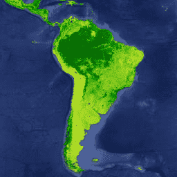
Terra MODIS Vegetation Continuous Fields (VCF) ürünü, küresel olarak yüzey bitki örtüsü tahminlerinin alt piksel düzeyinde bir gösterimidir. Dünyanın karasal yüzeyini temel bitki örtüsü özelliklerinin bir oranı olarak sürekli temsil etmek üzere tasarlanmıştır. Üç yüzey örtüsü bileşeninin derecelendirmesini sağlar: ağaç örtüsü yüzdesi, ağaç dışı örtü yüzdesi ve çıplak alan yüzdesi. VCF ürünleri, arazi yüzeyinin sürekli ve nicel bir tasvirini sunar. Bu tasvir, gelişmiş mekansal ayrıntılar içerir. Bu nedenle, VCF ürünleri çevre modelleme ve izleme uygulamalarında yaygın olarak kullanılır.
Yıllık olarak oluşturulan VCF ürünü, yedi bant ve arazi yüzey sıcaklığı dahil olmak üzere Terra MODIS 250 ve 500 metre arazi yüzey yansıtma verilerinin aylık kompozitleri kullanılarak üretilir.
Belgeler:
Bantlar
Bantlar
Piksel boyutu: 250 metre (tüm bantlar)
| Ad | Birimler | Min. | Maks. | Ölçek | Piksel Boyutu | Açıklama | |||||||||||||||||||||||||||||||||||||||||||||||||||||||||||||||||||||||||||||||||||||||||||||
|---|---|---|---|---|---|---|---|---|---|---|---|---|---|---|---|---|---|---|---|---|---|---|---|---|---|---|---|---|---|---|---|---|---|---|---|---|---|---|---|---|---|---|---|---|---|---|---|---|---|---|---|---|---|---|---|---|---|---|---|---|---|---|---|---|---|---|---|---|---|---|---|---|---|---|---|---|---|---|---|---|---|---|---|---|---|---|---|---|---|---|---|---|---|---|---|---|---|---|---|
Percent_Tree_Cover |
% | 0 | 100 | 250 metre | Ağaç örtüsüyle kaplı piksel yüzdesi |
||||||||||||||||||||||||||||||||||||||||||||||||||||||||||||||||||||||||||||||||||||||||||||||
Percent_NonTree_Vegetation |
% | 0 | 100 | 250 metre | Ağaç dışı bitkilerle kaplı piksel yüzdesi |
||||||||||||||||||||||||||||||||||||||||||||||||||||||||||||||||||||||||||||||||||||||||||||||
Percent_NonVegetated |
% | 0 | 100 | 250 metre | Bitki örtüsü olmayan piksel yüzdesi |
||||||||||||||||||||||||||||||||||||||||||||||||||||||||||||||||||||||||||||||||||||||||||||||
Quality |
250 metre | Kalitesi düşük olan girişleri (bulutlu, yüksek aerosol, bulut gölgesi veya görüş zeniti >45°) açıklar. Alandaki her bit, model için 8 giriş yüzeyi yansıtma dosyasından 1'ini temsil eder. |
|||||||||||||||||||||||||||||||||||||||||||||||||||||||||||||||||||||||||||||||||||||||||||||||||
Percent_Tree_Cover_SD |
% | 0 | 32767 | 0,01 | 250 metre | Yüzde bitki örtüsü veri katmanındaki piksel değerini oluşturmak için kullanılan 30 modelin standart sapması (SD) |
|||||||||||||||||||||||||||||||||||||||||||||||||||||||||||||||||||||||||||||||||||||||||||||
Percent_NonVegetated_SD |
% | 0 | 32767 | 0,01 | 250 metre | Bitki örtüsü içermeyen yüzde veri katmanındaki piksel değerini oluşturmak için kullanılan 30 modelin standart sapması (SD) |
|||||||||||||||||||||||||||||||||||||||||||||||||||||||||||||||||||||||||||||||||||||||||||||
Cloud |
250 metre | "Kalite" katmanını netleştirerek kullanıcıya "kötü" verilerin bulutlu giriş verilerini ifade ettiği konusunda bilgi verir. Alandaki her bit, modele yönelik 8 giriş yüzeyi yansıtma dosyasından 1'ini temsil eder. |
|||||||||||||||||||||||||||||||||||||||||||||||||||||||||||||||||||||||||||||||||||||||||||||||||
Kullanım Şartları
Kullanım Şartları
LP DAAC aracılığıyla edinilen MODIS verileri ve ürünleri, daha sonraki kullanım, satış veya yeniden dağıtım açısından herhangi bir kısıtlamaya tabi değildir.
Alıntılar
LP DAAC veri kümelerini alıntılamayla ilgili bilgi için lütfen LP DAAC "Verilerimizi Alıntılama" sayfasını ziyaret edin.
Earth Engine ile Keşif
Kod Düzenleyici (JavaScript)
var dataset = ee.ImageCollection('MODIS/006/MOD44B');

var visualization = {
  bands: ['Percent_Tree_Cover'],
  min: 0,
  max: 100,
  palette: ['bbe029', '0a9501', '074b03']
};

Map.setCenter(6.746, 46.529, 3);

Map.addLayer(dataset, visualization, 'Percent Tree Cover');