- Veri Kümesi Kullanılabilirliği
- 2000-02-24T00:00:00Z–2024-06-01T00:00:00Z
- Veri Kümesi Üreticisi
- USGS EROS Center'da NASA LP DAAC
- Sıklık
- 1 Gün
- Etiketler
Açıklama
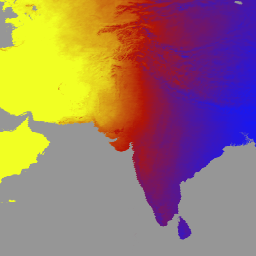
MCD18A1 Sürüm 6.1, 3 saatte bir DSR tahminleriyle 1 kilometre piksel çözünürlüğünde günlük olarak üretilen, Orta Çözünürlüklü Görüntüleme Spektroradyometresi (MODIS) Terra ve Aqua'nın birleştirilmiş Aşağı Yönlü Kısa Dalga Radyasyonu (DSR) ızgaralanmış 3. Seviye ürünüdür. DSR,kısa dalga spektrumunda (300-4.000 nanometre) kara yüzeylerine gelen güneş radyasyonudur ve çeşitli bilimsel ve uygulama sorunlarını ele alan kara yüzeyi modellerinde önemli bir değişkendir. MCD18 ürünleri, yüzey yansıtma değerini elde etmek için MODIS verilerinin çok zamanlı imzalarını kullanan ve ardından arama tablosu (LUT) yaklaşımını kullanarak gelen DSR'yi hesaplayan bir prototip oluşturma algoritmasına dayanır. LUT'lar, çeşitli aydınlatma/görüntüleme geometrisinde farklı aerosol ve bulut yükleme türlerini dikkate alır. Global DSR ürünleri, MODIS ve jeostatik uydu verilerinden oluşturulur. Verileri oluşturmak için kullanılan yöntemle ilgili ek ayrıntılar Algoritma Teorik Temel Belgesi'nde yer almaktadır.
Bantlar
Bantlar
Piksel boyutu: 500 metre (tüm bantlar)
| Ad | Birimler | Min. | Maks. | Piksel Boyutu | Açıklama | ||||||||||||||||||||||||||||||||||||||||||||||||||||||||||||||||||||||||||||||||||||||||||||||
|---|---|---|---|---|---|---|---|---|---|---|---|---|---|---|---|---|---|---|---|---|---|---|---|---|---|---|---|---|---|---|---|---|---|---|---|---|---|---|---|---|---|---|---|---|---|---|---|---|---|---|---|---|---|---|---|---|---|---|---|---|---|---|---|---|---|---|---|---|---|---|---|---|---|---|---|---|---|---|---|---|---|---|---|---|---|---|---|---|---|---|---|---|---|---|---|---|---|---|---|
DSR |
W/m^2 | 0 | 1.400 | 500 metre | MODIS geçişinde anlık toplam DSR |
||||||||||||||||||||||||||||||||||||||||||||||||||||||||||||||||||||||||||||||||||||||||||||||
Direct |
W/m^2 | 0 | 1.400 | 500 metre | MODIS üst geçidinde anlık doğrudan DSR |
||||||||||||||||||||||||||||||||||||||||||||||||||||||||||||||||||||||||||||||||||||||||||||||
Diffuse |
W/m^2 | 0 | 1.400 | 500 metre | MODIS geçişinde anlık dağınık DSR |
||||||||||||||||||||||||||||||||||||||||||||||||||||||||||||||||||||||||||||||||||||||||||||||
GMT_0000_DSR |
W/m^2 | 0 | 1.400 | 500 metre | GMT 00:00'daki toplam DSA |
||||||||||||||||||||||||||||||||||||||||||||||||||||||||||||||||||||||||||||||||||||||||||||||
GMT_0300_DSR |
W/m^2 | 0 | 1.400 | 500 metre | GMT 03:00'teki toplam DSR |
||||||||||||||||||||||||||||||||||||||||||||||||||||||||||||||||||||||||||||||||||||||||||||||
GMT_0600_DSR |
W/m^2 | 0 | 1.400 | 500 metre | GMT 06:00'daki toplam DSR |
||||||||||||||||||||||||||||||||||||||||||||||||||||||||||||||||||||||||||||||||||||||||||||||
GMT_0900_DSR |
W/m^2 | 0 | 1.400 | 500 metre | GMT 09:00'da toplam DSR |
||||||||||||||||||||||||||||||||||||||||||||||||||||||||||||||||||||||||||||||||||||||||||||||
GMT_1200_DSR |
W/m^2 | 0 | 1.400 | 500 metre | GMT 12:00'da toplam DSR |
||||||||||||||||||||||||||||||||||||||||||||||||||||||||||||||||||||||||||||||||||||||||||||||
GMT_1500_DSR |
W/m^2 | 0 | 1.400 | 500 metre | GMT 15:00'te toplam DSR |
||||||||||||||||||||||||||||||||||||||||||||||||||||||||||||||||||||||||||||||||||||||||||||||
GMT_1800_DSR |
W/m^2 | 0 | 1.400 | 500 metre | GMT 18:00'deki toplam DSR |
||||||||||||||||||||||||||||||||||||||||||||||||||||||||||||||||||||||||||||||||||||||||||||||
GMT_2100_DSR |
W/m^2 | 0 | 1.400 | 500 metre | GMT 21:00'de toplam DSR |
||||||||||||||||||||||||||||||||||||||||||||||||||||||||||||||||||||||||||||||||||||||||||||||
DSR_Quality |
500 metre | Kalite işareti |
|||||||||||||||||||||||||||||||||||||||||||||||||||||||||||||||||||||||||||||||||||||||||||||||||
Kullanım Şartları
Kullanım Şartları
LP DAAC aracılığıyla edinilen MODIS verileri ve ürünleri, daha sonraki kullanım, satış veya yeniden dağıtım açısından herhangi bir kısıtlamaya tabi değildir.
Alıntılar
LP DAAC veri kümelerini alıntılamayla ilgili bilgi için lütfen LP DAAC "Verilerimizi Alıntılama" sayfasını ziyaret edin.
DOI'lar
Earth Engine ile Keşif
Kod Düzenleyici (JavaScript)
var dataset = ee.ImageCollection('MODIS/061/MCD18A1')
                  .filter(ee.Filter.date('2000-01-01', '2001-01-01'));
var gmt_1200_dsr = dataset.select('GMT_1200_DSR');
var gmt_1200_dsr_vis = {
  min: 0,
  max: 350,
  palette: ['0f17ff', 'b11406', 'f1ff23'],
};
Map.setCenter(6.746, 46.529, 2);
Map.addLayer(
    gmt_1200_dsr, gmt_1200_dsr_vis,
    'Total dsr at GMT 12:00');