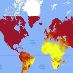
MCD18C2 Sürüm 6.1, 0,05 derece (Ekvator'da 5.600 metre) çözünürlükte günlük olarak üretilen, 3 saatte bir PAR tahminleriyle birlikte, orta çözünürlüklü görüntüleme spektroradyometresi (MODIS) Terra ve Aqua'nın birleştirilmiş fotosentetik olarak aktif radyasyon (PAR) ızgaralı Seviye 3 ürünüdür. PAR, görünür spektrumdaki (400-700 nanometre) gelen güneş radyasyonudur ve çeşitli bilimsel ve uygulama sorunlarını ele alan kara yüzeyi modellerinde önemli bir değişkendir. MCD18 ürünleri, yüzey yansıtma değerini elde etmek için MODIS verilerinin çok zamanlı imzalarını kullanan ve ardından arama tablosu (LUT) yaklaşımını kullanarak gelen PAR'ı hesaplayan bir prototip oluşturma algoritmasına dayanır. LUT'lar, çeşitli aydınlatma/görüntüleme geometrisinde farklı aerosol ve bulut yükleme türlerini dikkate alır. Küresel
PAR ürünleri, MODIS ve jeostatik uydu verilerinden oluşturulur.
Verileri oluşturmak için kullanılan yöntemle ilgili ek ayrıntıları Algoritma Teorik Temel Belgesi'nde bulabilirsiniz.
Bantlar
Piksel Boyutu 500 metre
Bantlar
Ad
Piksel Boyutu
Açıklama
GMT_0000_PAR
metre
GMT 00:00'daki toplam PAR
GMT_0300_PAR
metre
GMT 03:00'te toplam PAR
GMT_0600_PAR
metre
GMT 06:00'daki toplam PAR
GMT_0900_PAR
metre
GMT 09:00'da toplam PAR
GMT_1200_PAR
metre
GMT 12:00'de toplam PAR
GMT_1500_PAR
metre
GMT 15:00'te toplam PAR
GMT_1800_PAR
metre
GMT 18:00'de toplam PAR
GMT_2100_PAR
metre
GMT 21:00'de toplam PAR
Kullanım Şartları
Kullanım Şartları
LP DAAC aracılığıyla edinilen MODIS verileri ve ürünleri, sonraki kullanım, satış veya yeniden dağıtım açısından herhangi bir kısıtlamaya tabi değildir.
MCD18C2 Sürüm 6.1, 3 saatte bir PAR tahminleriyle 0,05 derece (ekvatorda 5.600 metre) çözünürlükte günlük olarak üretilen, Orta Çözünürlüklü Görüntüleme Spektroradyometresi (MODIS) Terra ve Aqua'nın birleştirilmiş Fotosentetik Olarak Aktif Radyasyon (PAR) ızgaralı Seviye 3 ürünüdür. PAR, görünür spektrumdaki gelen güneş radyasyonudur…
[null,null,[],[[["\u003cp\u003eMCD18C2 V6.1 provides daily, 3-hourly estimates of Photosynthetically Active Radiation (PAR) at 500-meter resolution using MODIS Terra and Aqua data.\u003c/p\u003e\n"],["\u003cp\u003eThis dataset covers the period from February 24, 2002, to June 1, 2024, and is based on surface reflectance derived from MODIS observations.\u003c/p\u003e\n"],["\u003cp\u003ePAR, crucial for land-surface models, is calculated using a look-up table approach considering aerosols, clouds, and illumination geometry.\u003c/p\u003e\n"],["\u003cp\u003eAlthough V6.1 is no longer being produced and has been replaced by V6.2, it remains available through Google Earth Engine.\u003c/p\u003e\n"],["\u003cp\u003eThe data has no restrictions on use, sale, or redistribution and is provided by NASA LP DAAC at the USGS EROS Center.\u003c/p\u003e\n"]]],["The MCD18C2 Version 6.1 dataset provides daily, gridded estimates of Photosynthetically Active Radiation (PAR) every 3 hours, derived from MODIS Terra and Aqua data. It's a Level 3 product, available from 2002-02-24 to 2024-06-01, at a 0.05-degree resolution. Data is provided at intervals `GMT_0000_PAR` to `GMT_2100_PAR` at each three hour mark, capturing the total PAR. It is accessible via Google Earth Engine and has no restrictions on use or redistribution. The data has been superseded by a new dataset.\n"],null,["# MCD18C2.061 Photosynthetically Active Radiation Daily 3-Hour [deprecated]\n\n**Caution:** This dataset has been superseded by [MODIS/062/MCD18C2](/earth-engine/datasets/catalog/MODIS_062_MCD18C2). \n\nDataset Availability\n: 2002-02-24T00:00:00Z--2024-06-01T00:00:00Z\n\nDataset Provider\n:\n\n\n [NASA LP DAAC at the USGS EROS Center](https://lpdaac.usgs.gov/products/mcd18c2v061/)\n\nCadence\n: 1 Day\n\nTags\n:\n climate \n par \nradiation \n\n#### Description\n\nThe MCD18C2 Version 6.1\nis a Moderate Resolution Imaging Spectroradiometer\n(MODIS) Terra and Aqua combined Photosynthetically Active Radiation (PAR)\ngridded Level 3 product produced daily at 0.05 degree (5,600 meters at the\nequator) resolution with estimates of PAR every 3 hours. PAR is incident\nsolar radiation in the visible spectrum (400-700 nanometers) and is an\nimportant variable in land-surface models that address a variety of\nscientific and application issues. The MCD18 products are based on a\nprototyping algorithm that uses multi-temporal signatures of MODIS data to\nderive surface reflectance and then calculate incident PAR using the look-up\ntable (LUT) approach. The LUTs consider different types of loadings of\naerosols and clouds at a variety of illumination/viewing geometry. Global\nPAR products are generated from MODIS and geostationary satellite data.\nAdditional details regarding the methodology used to create the data are\navailable in the\n[Algorithm Theoretical Basis Document](https://lpdaac.usgs.gov/documents/106/MCD18_ATBD.pdf)\n\n### Bands\n\n\n**Pixel Size**\n\n500 meters\n\n**Bands**\n\n| Name | Pixel Size | Description |\n|----------------|------------|------------------------|\n| `GMT_0000_PAR` | meters | Total PAR at GMT 00:00 |\n| `GMT_0300_PAR` | meters | Total PAR at GMT 03:00 |\n| `GMT_0600_PAR` | meters | Total PAR at GMT 06:00 |\n| `GMT_0900_PAR` | meters | Total PAR at GMT 09:00 |\n| `GMT_1200_PAR` | meters | Total PAR at GMT 12:00 |\n| `GMT_1500_PAR` | meters | Total PAR at GMT 15:00 |\n| `GMT_1800_PAR` | meters | Total PAR at GMT 18:00 |\n| `GMT_2100_PAR` | meters | Total PAR at GMT 21:00 |\n\n### Terms of Use\n\n**Terms of Use**\n\nMODIS data and products acquired through the LP DAAC\nhave no restrictions on subsequent use, sale, or redistribution.\n\n### Citations\n\nCitations:\n\n- Please visit [LP DAAC 'Citing Our Data' page](https://lpdaac.usgs.gov/citing_our_data)\n for information on citing LP DAAC datasets.\n\n### DOIs\n\n- \u003chttps://doi.org/10.5067/MODIS/MCD18C2.061\u003e\n\n### Explore with Earth Engine\n\n| **Important:** Earth Engine is a platform for petabyte-scale scientific analysis and visualization of geospatial datasets, both for public benefit and for business and government users. Earth Engine is free to use for research, education, and nonprofit use. To get started, please [register for Earth Engine access.](https://console.cloud.google.com/earth-engine)\n\n### Code Editor (JavaScript)\n\n```javascript\nvar dataset = ee.ImageCollection('MODIS/061/MCD18C2')\n .filter(ee.Filter.date('2001-01-01', '2001-02-01'));\nvar gmt_1200_par = dataset.select('GMT_1200_PAR');\nvar gmt_1200_par_vis = {\n min: -236,\n max: 316,\n palette: ['0f17ff', 'b11406', 'f1ff23'],\n};\nMap.setCenter(6.746, 46.529, 2);\nMap.addLayer(\n gmt_1200_par, gmt_1200_par_vis,\n 'Total PAR at GMT 12:00');\n```\n[Open in Code Editor](https://code.earthengine.google.com/?scriptPath=Examples:Datasets/MODIS/MODIS_061_MCD18C2) \n[MCD18C2.061 Photosynthetically Active Radiation Daily 3-Hour \\[deprecated\\]](/earth-engine/datasets/catalog/MODIS_061_MCD18C2) \nThe MCD18C2 Version 6.1 is a Moderate Resolution Imaging Spectroradiometer (MODIS) Terra and Aqua combined Photosynthetically Active Radiation (PAR) gridded Level 3 product produced daily at 0.05 degree (5,600 meters at the equator) resolution with estimates of PAR every 3 hours. PAR is incident solar radiation in the visible spectrum ... \nMODIS/061/MCD18C2, climate,par,radiation \n2002-02-24T00:00:00Z/2024-06-01T00:00:00Z \n-90 -180 90 180 \nGoogle Earth Engine \nhttps://developers.google.com/earth-engine/datasets\n\n- [https://doi.org/10.5067/MODIS/MCD18C2.061](https://doi.org/https://lpdaac.usgs.gov/products/mcd18c2v061/)\n- [https://doi.org/10.5067/MODIS/MCD18C2.061](https://doi.org/https://developers.google.com/earth-engine/datasets/catalog/MODIS_061_MCD18C2)"]]