- Disponibilidade do conjunto de dados
- 2000-02-18T00:00:00Z–2026-04-23T00:00:00Z
- Produtor do conjunto de dados
- NASA NSIDC DAAC at CIRES
- Cadência
- 1 dia
- Tags
Descrição
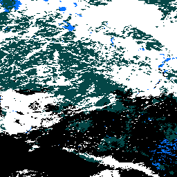
O MOD10A2 é um conjunto de dados de cobertura de neve do MODIS no satélite Terra. O conjunto de dados informa a extensão máxima da cobertura de neve durante um período de oito dias na resolução de 500 m.
Um período de composição de oito dias foi escolhido porque esse é o período exato de repetição da faixa de solo das plataformas Terra e Aqua. A cobertura de neve em oito dias é mapeada como extensão máxima de neve em um SDS e como uma cronologia de observações no outro SDS. Os períodos de oito dias começam no primeiro dia do ano e se estendem até o ano seguinte. O produto pode ser produzido com dois a oito dias de entrada. Pode não haver sempre oito dias de entrada, por vários motivos. Portanto, o usuário precisa verificar os atributos para determinar em quais dias as observações foram feitas.
- Documentação geral
- Guia do usuário (link em inglês)
Bandas
Bandas
Tamanho do pixel: 500 metros (todas as bandas)
| Nome | Mín. | Máx. | Tamanho do pixel | Descrição | |||||||||||||||||||||||||||||||||||||||||||||||||||||||||||||||||||||||||||||||||||||||||||||||
|---|---|---|---|---|---|---|---|---|---|---|---|---|---|---|---|---|---|---|---|---|---|---|---|---|---|---|---|---|---|---|---|---|---|---|---|---|---|---|---|---|---|---|---|---|---|---|---|---|---|---|---|---|---|---|---|---|---|---|---|---|---|---|---|---|---|---|---|---|---|---|---|---|---|---|---|---|---|---|---|---|---|---|---|---|---|---|---|---|---|---|---|---|---|---|---|---|---|---|---|
Maximum_Snow_Extent |
0 | 255 | 500 metros | Extensão máxima de neve observada durante um período de oito dias. |
|||||||||||||||||||||||||||||||||||||||||||||||||||||||||||||||||||||||||||||||||||||||||||||||
Eight_Day_Snow_Cover |
500 metros | Indicadores de bits de cronologia de neve para cada dia no período de observação de oito dias. |
|||||||||||||||||||||||||||||||||||||||||||||||||||||||||||||||||||||||||||||||||||||||||||||||||
Tabela de classes Maximum_Snow_Extent
| Valor | Cor | Descrição |
|---|---|---|
| 0 | Nenhum | Dados ausentes |
| 1 | Nenhum | Sem decisão |
| 11 | Nenhum | Noite |
| 25 | Nenhum | Sem neve |
| 37 | Nenhum | Lago |
| 39 | Nenhum | Oceano |
| 50 | Nenhum | Cloud |
| 100 | Nenhum | Gelo no lago |
| 200 | Nenhum | Neve |
| 254 | Nenhum | Detector saturado |
Termos de Uso
Termos de Uso
Você pode fazer o download e usar fotografias, imagens ou textos do site do NSIDC, a menos que as limitações de uso sejam especificamente declaradas. Para mais informações sobre o uso e a citação de conjuntos de dados do NSIDC, acesse a página "Uso e direitos autorais" do NSIDC.
Citações
Hall, D. K., V. V. Salomonson e G. A. Riggs. 2016. MODIS/Terra Snow Cover Daily L3 Global 500m Grid. Versão 6. Boulder, Colorado, EUA: NASA National Snow and Ice Data Center Distributed Active Archive Center.
Identificadores DOI
Explore com o Earth Engine
Editor de código (JavaScript)
var dataset = ee.ImageCollection('MODIS/061/MOD10A2')
  .filter(ee.Filter.date('2023-01-01', '2023-12-01'))
  .select('Maximum_Snow_Extent');

var visualization = {
  min: 50.0,
  max: 200.0,
  palette: [
    '000000',
    '0dffff',
    '0524ff',
    'ffffff'
  ]
};


Map.setCenter(-3.69, 65.99, 4);

Map.addLayer(dataset.mean(), visualization, 'Maximum_Snow_Extent');