Zbiór danych MOD21A1N jest tworzony codziennie na podstawie nocnych produktów LST na poziomie 2 – siatki (L2G) o rozdzielczości przestrzennej 1000 metrów. Proces L2G
mapuje dzienne granulki pasma MOD21 na siatkę sinusoidalną MODIS i
przechowuje wszystkie obserwacje przypadające na komórkę siatki w danym dniu. Algorytm MOD21A1 sortuje te obserwacje dla każdej komórki i szacuje końcową wartość LST jako średnią ze wszystkich obserwacji, które są wolne od chmur i mają dobrą dokładność LST&E. Średnia nocna jest ważona przez pokrycie obserwacyjne dla danej komórki. Pod uwagę brane są tylko obserwacje, których pokrycie przekracza próg 15%. Produkt MOD21A1N zawiera obliczoną temperaturę powierzchni lądu, a także kontrolę jakości, 3 pasma emisyjności, kąt zenitalny obserwacji i czas obserwacji.
Zbiór danych MOD21A1N jest tworzony codziennie na podstawie nocnych produktów LST poziomu 2 z siatką (L2G) o rozdzielczości przestrzennej 1000 m. Proces L2G mapuje dzienne granulki pasma MOD21 na siatkę sinusoidalną MODIS i przechowuje wszystkie obserwacje przypadające na komórkę siatki w danym dniu. …
[null,null,[],[[["\u003cp\u003eMOD21A1N provides daily nighttime land surface temperature (LST) and emissivity data at a 1,000-meter resolution globally.\u003c/p\u003e\n"],["\u003cp\u003eThe dataset is derived from MODIS Terra observations, averaging cloud-free, quality-assured LST measurements for each cell.\u003c/p\u003e\n"],["\u003cp\u003eIt includes quality control flags, emissivity bands, view zenith angle, and observation time for data validation and analysis.\u003c/p\u003e\n"],["\u003cp\u003eData is available from February 24, 2000, to December 10, 2024, and can be accessed through NASA's LP DAAC and Google Earth Engine.\u003c/p\u003e\n"],["\u003cp\u003eMODIS data and products acquired through the LP DAAC have no restrictions on subsequent use, sale, or redistribution.\u003c/p\u003e\n"]]],[],null,["Dataset Availability\n: 2000-02-24T00:00:00Z--2025-08-31T00:00:00Z\n\nDataset Provider\n:\n\n\n [NASA LP DAAC at the USGS EROS Center](https://doi.org/10.5067/MODIS/MOD21A1N.061)\n\nCadence\n: 1 Day\n\nTags\n:\n[climate](/earth-engine/datasets/tags/climate) [daily](/earth-engine/datasets/tags/daily) [emissivity](/earth-engine/datasets/tags/emissivity) [global](/earth-engine/datasets/tags/global) [lst](/earth-engine/datasets/tags/lst) [nasa](/earth-engine/datasets/tags/nasa) [surface-temperature](/earth-engine/datasets/tags/surface-temperature) [terra](/earth-engine/datasets/tags/terra) [usgs](/earth-engine/datasets/tags/usgs) \n\nDescription \nThe MOD21A1N dataset is produced daily from nighttime Level 2 Gridded (L2G)\nintermediate LST products at a spatial resolution of 1,000 meters. The L2G\nprocess maps the daily MOD21 swath granules onto a sinusoidal MODIS grid and\nstores all observations falling over a gridded cell for a given day. The\nMOD21A1 algorithm sorts through these observations for each cell and\nestimates the final LST value as an average from all observations that are\ncloud free and have good LST\\&E accuracies. The nighttime average is weighted\nby the observation coverage for that cell. Only observations having an\nobservation coverage greater than a 15% threshold are considered. The\nMOD21A1N product contains the calculated LST as well as quality control, the\nthree emissivity bands, view zenith angle, and time of observation.\n\nDocumentation:\n\n- [User's Guide](https://lpdaac.usgs.gov/documents/1398/MOD21_User_Guide_V61.pdf)\n\n- [Algorithm Theoretical Basis Document (ATBD)](https://lpdaac.usgs.gov/documents/1399/MOD21_ATBD.pdf)\n\n- [General Documentation](https://ladsweb.modaps.eosdis.nasa.gov/filespec/MODIS/61/MOD21A1N)\n\nBands\n\n\n**Pixel Size**\n\n1000 meters\n\n**Bands**\n\n| Name | Units | Min | Max | Pixel Size | Description |\n|--------------|-------|------|-------|------------|---------------------------|---|---|---|---|---|---|---|---|---|---|---|---|---|---|---|---|---|---|---|---|---|---|---|---|---|---|---|---|---|---|---|---|---|---|---|---|---|---|---|---|---|---|---|---|---|---|---|---|---|---|---|---|---|---|---|---|---|---|---|---|---|---|---|---|---|---|---|---|---|---|---|---|---|---|---|---|---|---|---|---|---|---|---|---|---|---|---|---|---|---|---|---|---|---|\n| `LST_1KM` | K | 7500 | 65535 | meters | Land Surface Temperature |\n| `QC` | | | | meters | Quality Control |\n| Bitmask for QC - Bits 0-1: Mandatory QA flags - 0: Pixel produced, good quality, no further QA info necessary - 1: Pixel produced, nominal quality. - 2: Pixel not produced due to cloud - 3: Pixel not produced due to reasons other than cloud - Bits 2-3: Data quality flag - 0: Good data quality of L1B bands 29, 31, 32 - 1: Missing pixel - 2: Fairly calibrated - 3: Poorly calibrated, TES processing skipped - Bits 4-5: Cloud Flag - 0: Cloud free - 1: Thin cirrus - 2: Pixel within 2 pixels of nearest cloud - 3: Cloudy pixel - Bits 6-7: TES Iterations - 0: =7 (Slow convergence) - 1: 6 (Nominal) - 2: 5 (Nominal) - 3: \\\u003c5 (Fast) - Bits 8-9: Atmospheric Opacity - 0: =3 (Warm, humid air; or cold land) - 1: 0.2 - 0.3 (Nominal value) - 2: 0.1 - 0.2 (Nominal value) - 3: \\\u003c0.1 (Dry, or high altitude pixel) - Bits 10-11: Min-Max Difference(MMD). Difference between minimum and maximum emissivity for bands 29, 31, 32 - 0: 0.15 (Most silicate rocks) - 1: 0.1 - 0.15 (Rocks, sand, some soils) - 2: 0.03 - 0.1 (Mostly soils, mixed pixel) - 3: \\\u003c0.03 (Vegetation, snow, water, ice) - Bits 12-13: Emissivity accuracy - 0: 0.02 (Poor performance) - 1: 0.015 - 0.02 (Marginal performance) - 2: 0.01 - 0.015 (Good performance) - 3: \\\u003c0.01 (Excellent performance) - Bits 14-15: LST accuracy - 0: 2 K (Poor performance) - 1: 1.5 - 2 K (Marginal performance) - 2: 1 - 1.5 K (Good performance) - 3: \\\u003c1 K (Excellent performance) ||||||||||||||||||||||||||||||||||||||||||||||||||||||||||||||||||||||||||||||||||||||||||||||||||||\n| `Emis_29` | | 0 | 255 | meters | Band 29 emissivity |\n| `Emis_31` | | 1 | 255 | meters | Band 31 emissivity |\n| `Emis_32` | | 1 | 255 | meters | Band 32 emissivity |\n| `View_Angle` | deg | 0 | 130 | meters | MODIS view zenith angle |\n| `View_Time` | h | 0 | 240 | meters | Time of MODIS observation |\n\nTerms of Use\n\n**Terms of Use**\n\nMODIS data and products acquired through the LP DAAC\nhave no restrictions on subsequent use, sale, or redistribution.\n\nCitations \nCitations:\n\n- Please visit [LP DAAC 'Citing Our Data' page](https://lpdaac.usgs.gov/citing_our_data)\n for information on citing LP DAAC datasets.\n\nDOIs\n\n- \u003chttps://doi.org/10.5067/MODIS/MOD21A1N.061\u003e\n\nExplore with Earth Engine **Important:** Earth Engine is a platform for petabyte-scale scientific analysis and visualization of geospatial datasets, both for public benefit and for business and government users. Earth Engine is free to use for research, education, and nonprofit use. To get started, please [register for Earth Engine access.](https://console.cloud.google.com/earth-engine)\n\nCode Editor (JavaScript) \n\n```javascript\n
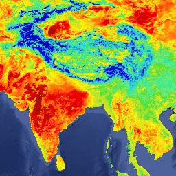
var dataset = ee.ImageCollection('MODIS/061/MOD21A1N')\n .filter(ee.Filter.date('2018-01-01', '2018-05-01'));\nvar landSurfaceTemperature = dataset.select('LST_1KM');\nvar landSurfaceTemperatureVis = {\n min: 216.0,\n max: 348.0,\n palette: [\n '040274', '040281', '0502a3', '0502b8', '0502ce', '0502e6',\n '0602ff', '235cb1', '307ef3', '269db1', '30c8e2', '32d3ef',\n '3be285', '3ff38f', '86e26f', '3ae237', 'b5e22e', 'd6e21f',\n 'fff705', 'ffd611', 'ffb613', 'ff8b13', 'ff6e08', 'ff500d',\n 'ff0000', 'de0101', 'c21301', 'a71001', '911003'\n ],\n};\nMap.setCenter(6.746, 46.529, 2);\nMap.addLayer(\n landSurfaceTemperature, landSurfaceTemperatureVis,\n 'Land Surface Temperature');\n```\n[Open in Code Editor](https://code.earthengine.google.com/?scriptPath=Examples:Datasets/MODIS/MODIS_061_MOD21A1N) \n[MOD21A1N.061 Terra Land Surface Temperature and 3-Band Emissivity Daily Global 1km](/earth-engine/datasets/catalog/MODIS_061_MOD21A1N) \nThe MOD21A1N dataset is produced daily from nighttime Level 2 Gridded (L2G) intermediate LST products at a spatial resolution of 1,000 meters. The L2G process maps the daily MOD21 swath granules onto a sinusoidal MODIS grid and stores all observations falling over a gridded cell for a given day. The ... \nMODIS/061/MOD21A1N, climate,daily,emissivity,global,lst,nasa,surface-temperature,terra,usgs \n2000-02-24T00:00:00Z/2025-08-31T00:00:00Z \n-90 -180 90 180 \nGoogle Earth Engine \nhttps://developers.google.com/earth-engine/datasets\n\n- [https://doi.org/10.5067/MODIS/MOD21A1N.061](https://doi.org/https://doi.org/10.5067/MODIS/MOD21A1N.061)\n- [https://doi.org/10.5067/MODIS/MOD21A1N.061](https://doi.org/https://developers.google.com/earth-engine/datasets/catalog/MODIS_061_MOD21A1N)"]]