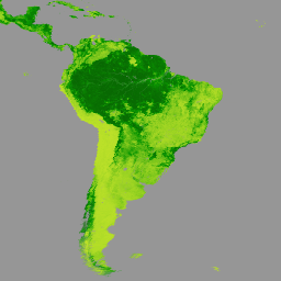
Terra MODIS 植被連續場 (VCF) 產品是全球地表植被覆蓋估計值的次像素級表示法。這項資料集會持續以基本植被特徵的比例,呈現地球陸地表面,並提供三種地表覆蓋成分的漸層:樹木覆蓋率、非樹木覆蓋率和裸地率。VCF 產品可持續量化呈現地表覆蓋情形,並提供更精細的空間資訊,因此廣泛用於環境模擬和監控應用程式。
VCF 產品每年生成一次,是使用 Terra MODIS 250 和 500 公尺地表反射率資料的月度合成資料 (包括所有七個波段和地表溫度) 製作而成。
[null,null,[],[],["The Terra MODIS VCF product, available from 2000-03-05 to 2023-03-06 via NASA LP DAAC, offers yearly global vegetation cover data. It uses 250-meter resolution to estimate percent tree cover, non-tree vegetation, and bare ground. Data is derived from Terra MODIS Land Surface Reflectance. The product includes quality and cloud data indicators. Access to use is through google Earth engine, with JavaScript code examples for visualization.\n"],null,["# MOD44B.061 Terra Vegetation Continuous Fields Yearly Global 250m\n\nDataset Availability\n: 2000-03-05T00:00:00Z--2024-03-05T00:00:00Z\n\nDataset Provider\n:\n\n\n [NASA LP DAAC at the USGS EROS Center](https://doi.org/10.5067/MODIS/MOD44B.006)\n\nCadence\n: 1 Year\n\nTags\n:\n [annual](/earth-engine/datasets/tags/annual) [geophysical](/earth-engine/datasets/tags/geophysical) [global](/earth-engine/datasets/tags/global) [landuse-landcover](/earth-engine/datasets/tags/landuse-landcover) [modis](/earth-engine/datasets/tags/modis) [nasa](/earth-engine/datasets/tags/nasa) [terra](/earth-engine/datasets/tags/terra) [tree-cover](/earth-engine/datasets/tags/tree-cover) [vegetation](/earth-engine/datasets/tags/vegetation) \nmod44b \n\n#### Description\n\nThe Terra MODIS Vegetation Continuous Fields (VCF)\nproduct is a sub-pixel-level representation of surface vegetation\ncover estimates globally. Designed to continuously represent\nEarth's terrestrial surface as a proportion of basic vegetation\ntraits, it provides a gradation of three surface cover components:\npercent tree cover, percent non-tree cover, and percent bare.\nVCF products provide a continuous, quantitative portrayal of\nland surface cover with improved spatial detail, and hence, are\nwidely used in environmental modeling and monitoring applications.\n\nGenerated yearly, the VCF product is produced using monthly\ncomposites of Terra MODIS 250 and 500 meters Land Surface Reflectance\ndata, including all seven bands, and Land Surface Temperature.\n\nDocumentation:\n\n- [User's Guide](https://lpdaac.usgs.gov/documents/1494/MOD44B_User_Guide_V61.pdf)\n\n- [Algorithm Theoretical Basis Document (ATBD)](https://lpdaac.usgs.gov/documents/113/MOD44B_ATBD.pdf)\n\n- [General Documentation](https://lpdaac.usgs.gov/products/mod44bv061/)\n\n### Bands\n\n\n**Pixel Size**\n\n250 meters\n\n**Bands**\n\n| Name | Units | Min | Max | Scale | Pixel Size | Description |\n|------------------------------|-------|-----|-------|-------|------------|---------------------------------------------------------------------------------------------------------------------------------------------------------------------------------------------------------|---|---|---|---|---|---|---|---|---|---|---|---|---|---|---|---|---|---|---|---|---|---|---|---|---|---|---|---|---|---|---|---|---|---|---|---|---|---|---|---|---|---|---|---|---|---|---|---|---|---|---|---|---|---|---|---|---|---|---|---|---|---|---|---|---|---|---|---|---|---|---|---|---|---|---|---|---|---|---|---|---|---|---|---|---|---|---|---|---|---|---|---|---|\n| `Percent_Tree_Cover` | % | 0 | 100 | | meters | Percent of a pixel which is covered by tree canopy |\n| `Percent_NonTree_Vegetation` | % | 0 | 100 | | meters | Percent of a pixel which is covered by non-tree vegetation |\n| `Percent_NonVegetated` | % | 0 | 100 | | meters | Percent of a pixel which is not vegetated |\n| `Quality` | | | | | meters | Describes those inputs that had poor quality (cloudy, high aerosol, cloud shadow, or view zenith \\\u003e45°). Each bit in the field represents 1 out of 8 input surface reflectance files to the model. |\n| Bitmask for Quality - Bit 0: State of input layers DOY 065-097 - 0: Clear - 1: Bad - Bit 1: State of input layers DOY 113-145 - 0: Clear - 1: Bad - Bit 2: State of input layers DOY 161-193 - 0: Clear - 1: Bad - Bit 3: State of input layers DOY 209-241 - 0: Clear - 1: Bad - Bit 4: State of input layers DOY 257-289 - 0: Clear - 1: Bad - Bit 5: State of input layers DOY 305-337 - 0: Clear - 1: Bad - Bit 6: State of input layers DOY 353-017 - 0: Clear - 1: Bad - Bit 7: State of input layers DOY 033-045 - 0: Clear - 1: Bad ||||||||||||||||||||||||||||||||||||||||||||||||||||||||||||||||||||||||||||||||||||||||||||||||||||\n| `Percent_Tree_Cover_SD` | % | 0 | 32767 | 0.01 | meters | Standard deviation (SD) of the 30 models that were used to generate the pixel value in the percent tree cover data layer |\n| `Percent_NonVegetated_SD` | % | 0 | 32767 | 0.01 | meters | Standard deviation (SD) of the 30 models that were used to generate the pixel value in the percent non-vegetated data layer |\n| `Cloud` | | | | | meters | Clarifies the 'Quality' layer to give the user an indication that the 'bad' data refers to cloudy input data. Each bit in the field represents 1 out of 8 input surface reflectance files to the model. |\n| Bitmask for Cloud - Bit 0: State of input layers DOY 065-097 - 0: Clear - 1: Cloudy - Bit 1: State of input layers DOY 113-145 - 0: Clear - 1: Cloudy - Bit 2: State of input layers DOY 161-193 - 0: Clear - 1: Cloudy - Bit 3: State of input layers DOY 209-241 - 0: Clear - 1: Cloudy - Bit 4: State of input layers DOY 257-289 - 0: Clear - 1: Cloudy - Bit 5: State of input layers DOY 305-337 - 0: Clear - 1: Cloudy - Bit 6: State of input layers DOY 353-017 - 0: Clear - 1: Cloudy - Bit 7: State of input layers DOY 033-045 - 0: Clear - 1: Cloudy ||||||||||||||||||||||||||||||||||||||||||||||||||||||||||||||||||||||||||||||||||||||||||||||||||||\n\n### Terms of Use\n\n**Terms of Use**\n\nMODIS data and products acquired through the LP DAAC\nhave no restrictions on subsequent use, sale, or redistribution.\n\n### Citations\n\nCitations:\n\n- Please visit [LP DAAC 'Citing Our Data' page](https://lpdaac.usgs.gov/citing_our_data)\n for information on citing LP DAAC datasets.\n\n### Explore with Earth Engine\n\n| **Important:** Earth Engine is a platform for petabyte-scale scientific analysis and visualization of geospatial datasets, both for public benefit and for business and government users. Earth Engine is free to use for research, education, and nonprofit use. To get started, please [register for Earth Engine access.](https://console.cloud.google.com/earth-engine)\n\n### Code Editor (JavaScript)\n\n```javascript\nvar dataset = ee.ImageCollection('MODIS/061/MOD44B')\n .filter(ee.Filter.date('2000-01-01', '2001-01-01'));\n\nvar visualization = {\n bands: ['Percent_Tree_Cover'],\n min: 0,\n max: 100,\n palette: ['bbe029', '0a9501', '074b03']\n};\n\nMap.setCenter(6.746, 46.529, 3);\n\nMap.addLayer(dataset, visualization, 'Percent Tree Cover');\n```\n[Open in Code Editor](https://code.earthengine.google.com/?scriptPath=Examples:Datasets/MODIS/MODIS_061_MOD44B) \n[MOD44B.061 Terra Vegetation Continuous Fields Yearly Global 250m](/earth-engine/datasets/catalog/MODIS_061_MOD44B) \nThe Terra MODIS Vegetation Continuous Fields (VCF) product is a sub-pixel-level representation of surface vegetation cover estimates globally. Designed to continuously represent Earth's terrestrial surface as a proportion of basic vegetation traits, it provides a gradation of three surface cover components: percent tree cover, percent non-tree cover, and percent bare. ... \nMODIS/061/MOD44B, annual,geophysical,global,landuse-landcover,modis,nasa,terra,tree-cover,vegetation \n2000-03-05T00:00:00Z/2024-03-05T00:00:00Z \n-90 -180 90 180 \nGoogle Earth Engine \nhttps://developers.google.com/earth-engine/datasets\n\n- [](https://doi.org/https://doi.org/10.5067/MODIS/MOD44B.006)\n- [](https://doi.org/https://developers.google.com/earth-engine/datasets/catalog/MODIS_061_MOD44B)"]]