- Disponibilidade de conjuntos de dados
- 2002-07-01T00:00:00Z–2025-11-01T00:00:00Z
- Provedor de conjunto de dados
- NASA LAADS DAAC no NASA Goddard Space Flight Center
- Cadência
- 1 mês
- Tags
Descrição
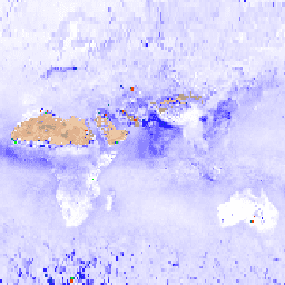
MYD08_M3 V6.1 é um produto global da atmosfera que contém valores médios mensais de grade de 1 x 1 grau de parâmetros atmosféricos. Esses parâmetros estão relacionados a propriedades de partículas de aerossol atmosférico, carga total de ozônio, vapor d'água atmosférico, propriedades ópticas e físicas de nuvens e índices de estabilidade atmosférica. O produto também fornece médias, desvios padrão, estatísticas ponderadas de controle de qualidade, distribuições log-normais, estimativas de incerteza e estatísticas para frações de pixels que atendem a alguma condição. Abaixo está um subconjunto das bandas. Para conferir a lista completa, acesse Lista de bandas MOD08.
Documentação:
Bandas
Tamanho do pixel
111.320 metros
Bandas
| Nome | Mín. | Máx. | Escala | Tamanho do pixel | Descrição |
|---|---|---|---|---|---|
Aerosol_Optical_Depth_Land_Ocean_Mean_Mean |
-100 | 5000 | 0,001 | metros | Espessura óptica do aerossol em 0,55 micrômetros para oceano (melhor) e terra (corrigida): média da média diária |
Aerosol_Optical_Depth_Land_Ocean_Std_Deviation_Mean |
-100 | 5000 | 0,001 | metros | Espessura óptica do aerossol em 0,55 mícrons para oceano (melhor) e terra (corrigida): média do desvio padrão diário |
Aerosol_Optical_Depth_Land_QA_Mean_Mean_470 |
-100 | 5000 | 0,001 | metros | Profundidade óptica de aerossol corrigida (terra) em 0,47 micrômetros: média da média ponderada de QA de nível 3 |
Aerosol_Optical_Depth_Land_QA_Std_Deviation_Mean_470 |
-100 | 5000 | 0,001 | metros | Profundidade óptica de aerossol corrigida (terra) em 0,47 mícrons: média do desvio padrão ponderado de qualidade de nível 3 |
Cirrus_Fraction_SWIR_FMean |
0 | 10000 | 0,0001 | metros | Fração da área de cirros: média da fração diária |
Cirrus_Fraction_SWIR_FStd |
0 | 10000 | 0,0001 | metros | Fração da área de cirro: desvio padrão da fração diária |
Cloud_Optical_Thickness_Liquid_Log_Mean_Mean |
0 | 4176 | 0,001 | metros | Espessura óptica da nuvem de água líquida: média da média diária do registro |
Cloud_Optical_Thickness_Liquid_Log_Std_Deviation_Mean |
0 | 4176 | 0,001 | metros | Espessura óptica da nuvem de água líquida: média do desvio padrão do log diário |
Cloud_Optical_Thickness_Liquid_Mean_Uncertainty |
0 | 2000 | 0,01 | metros | Espessura óptica da nuvem de água líquida: estimativa de incerteza absoluta de vários dias derivada da estimativa de incerteza absoluta diária |
Cloud_Optical_Thickness_Liquid_Log_Mean_Uncertainty |
0 | 4477 | 0,001 | metros | Espessura óptica da nuvem de água líquida: estimativa de incerteza absoluta de vários dias derivada da estimativa de incerteza absoluta diária |
Termos de Uso
Termos de Uso
Esse conjunto de dados está em domínio público e disponível sem restrições de uso e distribuição. Consulte a Política de dados e informações de ciências da Terra da NASA para mais informações.
Citações
Platnick, S., M. King, P. Hubanks, 2015. Produto mensal da atmosfera L3 do MODIS. NASA MODIS Adaptive Processing System, Goddard Space Flight Center, doi:10.5067/MODIS/MYD08_M3.061
DOIs
Descobrir com o Earth Engine
Editor de código (JavaScript)
var dataset = ee.ImageCollection('MODIS/006/MYD08_M3')
                  .filter(ee.Filter.date('2018-01-01', '2018-05-01'));
var aerosolOpticalDepth =
    dataset.select('Aerosol_Optical_Depth_Land_Ocean_Mean_Mean');
var aerosolOpticalDepthVis = {
  min: 0,
  max: 3000,
  palette: ['ffffff', '1303ff', '01ff09', 'ff2f00'],
};
Map.setCenter(6.746, 46.529, 2);
Map.addLayer(
    aerosolOpticalDepth, aerosolOpticalDepthVis, 'Aerosol Optical Depth');