- Disponibilidade de conjuntos de dados
- 2002-07-04T00:00:00Z–2025-12-19T00:00:00Z
- Provedor de conjunto de dados
- NASA LP DAAC no USGS EROS Center
- Cadência
- 8 dias
- Tags
Descrição
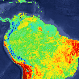
O produto MYD11A2 V6.1 fornece uma temperatura média da superfície terrestre (LST) de 8 dias em uma grade de 1.200 x 1.200 quilômetros. Cada valor de pixel em MYD11A2 é uma média simples de todos os pixels de LST MYD11A1 correspondentes coletados nesse período de oito dias. O MYD11A2 faz uma média simples de todos os valores diários de LST, sem filtrar bits de controle de qualidade específicos. Cada um dos valores de controle de qualidade do MYD11A2 é definido com base na maioria dos valores diários de controle de qualidade de entrada para um determinado pixel.
O período de composição de oito dias foi escolhido porque o dobro desse período é o período exato de repetição da trajetória no solo das plataformas Terra e Aqua. Nesse produto, além das bandas de temperatura da superfície diurna e noturna e das camadas de indicador de qualidade (QC), também estão as bandas 31 e 32 do MODIS e oito camadas de observação.
Documentação:
Bandas
Tamanho do pixel
1.000 metros
Bandas
| Nome | Unidades | Mín. | Máx. | Escala | Deslocamento | Tamanho do pixel | Descrição | ||||||||||||||||||||||||||||||||||||||||||||||||||||||||||||||||||||||||||||||||||||||||||||
|---|---|---|---|---|---|---|---|---|---|---|---|---|---|---|---|---|---|---|---|---|---|---|---|---|---|---|---|---|---|---|---|---|---|---|---|---|---|---|---|---|---|---|---|---|---|---|---|---|---|---|---|---|---|---|---|---|---|---|---|---|---|---|---|---|---|---|---|---|---|---|---|---|---|---|---|---|---|---|---|---|---|---|---|---|---|---|---|---|---|---|---|---|---|---|---|---|---|---|---|
LST_Day_1km |
K | 7.500 | 65535 | 0,02 | metros | Temperatura da superfície do solo durante o dia |
|||||||||||||||||||||||||||||||||||||||||||||||||||||||||||||||||||||||||||||||||||||||||||||
QC_Day |
metros | Indicadores de qualidade de LST diurnos |
|||||||||||||||||||||||||||||||||||||||||||||||||||||||||||||||||||||||||||||||||||||||||||||||||
Day_view_time |
h | 0 | 240 | 0,1 | metros | Horário local da observação |
|||||||||||||||||||||||||||||||||||||||||||||||||||||||||||||||||||||||||||||||||||||||||||||
Day_view_angl |
graus | 0 | 130 | -65 | metros | Ver o ângulo zenital da observação diurna |
|||||||||||||||||||||||||||||||||||||||||||||||||||||||||||||||||||||||||||||||||||||||||||||
LST_Night_1km |
K | 7.500 | 65635 | 0,02 | metros | Temperatura da superfície do solo à noite |
|||||||||||||||||||||||||||||||||||||||||||||||||||||||||||||||||||||||||||||||||||||||||||||
QC_Night |
metros | Indicadores de qualidade de LST noturno |
|||||||||||||||||||||||||||||||||||||||||||||||||||||||||||||||||||||||||||||||||||||||||||||||||
Night_view_time |
h | 0 | 240 | 0,1 | metros | Horário local da observação noturna |
|||||||||||||||||||||||||||||||||||||||||||||||||||||||||||||||||||||||||||||||||||||||||||||
Night_view_angl |
graus | 0 | 130 | -65 | metros | Ver o ângulo zenital da observação noturna |
|||||||||||||||||||||||||||||||||||||||||||||||||||||||||||||||||||||||||||||||||||||||||||||
Emis_31 |
1 | 255 | 0,002 | 0,49 | metros | Emissividade da banda 31 |
|||||||||||||||||||||||||||||||||||||||||||||||||||||||||||||||||||||||||||||||||||||||||||||
Emis_32 |
1 | 255 | 0,002 | 0,49 | metros | Emissividade da banda 32 |
|||||||||||||||||||||||||||||||||||||||||||||||||||||||||||||||||||||||||||||||||||||||||||||
Clear_sky_days |
metros | Dias com céu limpo |
|||||||||||||||||||||||||||||||||||||||||||||||||||||||||||||||||||||||||||||||||||||||||||||||||
Clear_sky_nights |
metros | Noites com céu limpo |
|||||||||||||||||||||||||||||||||||||||||||||||||||||||||||||||||||||||||||||||||||||||||||||||||
Termos de Uso
Termos de Uso
Os dados e produtos do MODIS adquiridos pelo LP DAAC não têm restrições quanto ao uso, venda ou redistribuição subsequentes.
Citações
Acesse a página "Como citar nossos dados" do LP DAAC para informações sobre como citar conjuntos de dados do LP DAAC.
DOIs
Explore com o Earth Engine
Editor de código (JavaScript)
var dataset = ee.ImageCollection('MODIS/061/MYD11A2')
                  .filter(ee.Filter.date('2018-01-01', '2018-05-01'));
var landSurfaceTemperature = dataset.select('LST_Day_1km');
var landSurfaceTemperatureVis = {
  min: 14000.0,
  max: 16000.0,
  palette: [
    '040274', '040281', '0502a3', '0502b8', '0502ce', '0502e6',
    '0602ff', '235cb1', '307ef3', '269db1', '30c8e2', '32d3ef',
    '3be285', '3ff38f', '86e26f', '3ae237', 'b5e22e', 'd6e21f',
    'fff705', 'ffd611', 'ffb613', 'ff8b13', 'ff6e08', 'ff500d',
    'ff0000', 'de0101', 'c21301', 'a71001', '911003'
  ],
};
Map.setCenter(6.746, 46.529, 2);
Map.addLayer(
    landSurfaceTemperature, landSurfaceTemperatureVis,
    'Land Surface Temperature');