- 데이터 세트 제공
- 2000-02-24T00:00:00Z–2025-12-09T00:00:00Z
- 데이터 세트 제공업체
- USGS EROS 센터 NASA LP DAAC
- 주기
- 1일
- 태그
설명
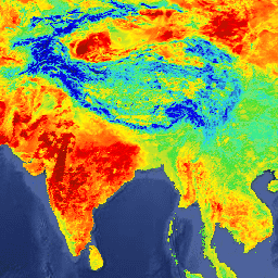
MYD21A1D 데이터 세트는 1,000m의 공간 해상도로 일간 레벨 2 그리드 (L2G) 중간 LST 제품에서 매일 생성됩니다. L2G 프로세스는 일일 MOD21 스와스 그레뉼을 사인파 MODIS 그리드에 매핑하고 주어진 날짜의 그리드 셀에 속하는 모든 관측치를 저장합니다. MOD21A1 알고리즘은 각 셀에 대해 이러한 관측치를 분류하고 구름이 없고 LST&E 정확도가 우수한 모든 관측치의 평균으로 최종 LST 값을 추정합니다. 주간 평균은 해당 셀의 관측 범위에 따라 가중치가 부여됩니다. 관측 범위가 15% 기준점보다 큰 관측치만 고려됩니다. MYD21A1D 제품에는 계산된 LST와 품질 관리, 3개의 방사율 대역, 시야각, 관측 시간이 포함됩니다.
문서:
대역
픽셀 크기
1,000미터
대역
| 이름 | 단위 | 최소 | 최대 | 픽셀 크기 | 설명 | ||||||||||||||||||||||||||||||||||||||||||||||||||||||||||||||||||||||||||||||||||||||||||||||
|---|---|---|---|---|---|---|---|---|---|---|---|---|---|---|---|---|---|---|---|---|---|---|---|---|---|---|---|---|---|---|---|---|---|---|---|---|---|---|---|---|---|---|---|---|---|---|---|---|---|---|---|---|---|---|---|---|---|---|---|---|---|---|---|---|---|---|---|---|---|---|---|---|---|---|---|---|---|---|---|---|---|---|---|---|---|---|---|---|---|---|---|---|---|---|---|---|---|---|---|
LST_1KM |
K | 7500 | 65535 | 미터 | 지표면 온도 |
||||||||||||||||||||||||||||||||||||||||||||||||||||||||||||||||||||||||||||||||||||||||||||||
QC |
미터 | 품질관리 |
|||||||||||||||||||||||||||||||||||||||||||||||||||||||||||||||||||||||||||||||||||||||||||||||||
Emis_29 |
0 | 255 | 미터 | 밴드 29 방사율 |
|||||||||||||||||||||||||||||||||||||||||||||||||||||||||||||||||||||||||||||||||||||||||||||||
Emis_31 |
1 | 255 | 미터 | 밴드 31 방사율 |
|||||||||||||||||||||||||||||||||||||||||||||||||||||||||||||||||||||||||||||||||||||||||||||||
Emis_32 |
1 | 255 | 미터 | 밴드 32 방사율 |
|||||||||||||||||||||||||||||||||||||||||||||||||||||||||||||||||||||||||||||||||||||||||||||||
View_Angle |
deg | 0 | 130 | 미터 | MODIS 관측 천정각 |
||||||||||||||||||||||||||||||||||||||||||||||||||||||||||||||||||||||||||||||||||||||||||||||
View_Time |
h | 0 | 240 | 미터 | MODIS 관측 시간 |
||||||||||||||||||||||||||||||||||||||||||||||||||||||||||||||||||||||||||||||||||||||||||||||
이용약관
이용약관
LP DAAC를 통해 획득한 MODIS 데이터 및 제품은 후속 사용, 판매 또는 재배포에 제한이 없습니다.
인용
인용
LP DAAC 데이터 세트 인용에 관한 자세한 내용은 LP DAAC '데이터 인용' 페이지를 참고하세요.
DOI
Earth Engine으로 탐색
코드 편집기(JavaScript)
var dataset = ee.ImageCollection('MODIS/061/MYD21A1D')
                  .filter(ee.Filter.date('2018-01-01', '2018-05-01'));
var landSurfaceTemperature = dataset.select('LST_1KM');
var landSurfaceTemperatureVis = {
  min: 216.0,
  max: 348.0,
  palette: [
    '040274', '040281', '0502a3', '0502b8', '0502ce', '0502e6',
    '0602ff', '235cb1', '307ef3', '269db1', '30c8e2', '32d3ef',
    '3be285', '3ff38f', '86e26f', '3ae237', 'b5e22e', 'd6e21f',
    'fff705', 'ffd611', 'ffb613', 'ff8b13', 'ff6e08', 'ff500d',
    'ff0000', 'de0101', 'c21301', 'a71001', '911003'
  ],
};
Map.setCenter(6.746, 46.529, 2);
Map.addLayer(
    landSurfaceTemperature, landSurfaceTemperatureVis,
    'Land Surface Temperature');